I'm heading for a bike packing trip across Scotland but recent heavy
rain and storm Gareth have affected the trains. I checked online
before leaving home and could see that my 08:03 train fro Preston
was still scheduled to run. The 06:40 was listed as cancelled. There
was a little rain on my ride to Preston and it was still quite
windy. I reached Preston railway station in good time and noticed
that my train was listed as running slightly late.
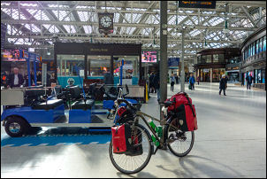
Glasgow Central Railway Station
I spent part of the time in the waiting room as it was quite cold on
the platform. At first the train was listed as a few minutes late
but became later and later as time progressed. It eventually arrived
at 8:30 and I wheeled my bike on and it was the only one in the
train. It is the TransPennine Express service to Glasgow so no
problem with the bike carrier as there is with Virgin. Due to the
strong winds there was a speed restriction of 80 miles per hour
making the train even later as we progressed. Around Carlisle the
speed restriction was lifted and we were back to 100 miles per hour.
I was pleased to see a USB port by my seat so was able to charge my
phone on the way.
The train was due into Glasgow at 10:33 a.m. but
it was 11:12 when we arrived. An announcement on the train said due
to the lateness compensation was payable by contacting their website tpexpress.co.uk.
I wheeled my bike outside Central Station and set off cycling south
then over the River Clyde to turn left and follow the cycle route.
The route was quite varied and a couple of sections have been closed
due to riverside subsidence. Fortunately I was able to find an easy
way round.
Bridge over the Clyde
One closed section meant a diversion and
then a steep climb up steps which annoyed me as they were obviously
not for cycles. I had to take one of my bags off to get the bike up
then go back and retrieve it. I left the riverside and was following
the main roads. Wherever possible and cycled on the footpath for
safety. I got through Cambuslang OK and followed the A724 then
turned off left through a housing estate to pick up a cycle route
I'd been on before.
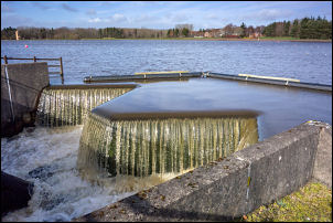
Flood barrier
I crossed over the River Clyde then followed the
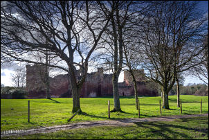
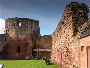
roads south to the west of Uddingston and made a short detour out to
Bothwell Castle. It had been raining heavily and I was trying out my
new cycle cape which seemed to perform fairly well though may be a
problem in strong winds. I stopped briefly at the castle and peered
in through the entrance and reception shop. There was a £2 charge to
go inside the castle grounds but I couldn't see much there. I didn't
stop but returned to Castle Avenue and on south.
Bothwell Castle
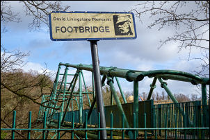
My next objective
was the David Livingstone Memorial Bridge over at the Clyde and as I
descended Blantyre Mill Road had to get off the bike and wheel it
for a while due to extensive roadworks. A new housing estate is
being built and pedestrians can just get through along the road. I
crossed over the bridge and cycled up Station Road. In Blantyre I
turn left to head east to follow the East Kilbride Expressway. There
is a large new interchange with the M74 and a cycle way flyover
which was interesting to cross. The cycle ways weren't well
signposted but eventually I got off them to reach the Strathclyde
Loch and Country Park.
Bothwell Castle
Crossing the David Livingstone Bridge
David Livingstone Memorial Footbridge
Adjacent to the David Livingstone Bridge
Strathclyde Country Park
It was enjoyable cycling along the side of
the Loch as the River Clyde was on my right and the lock on the
left. I followed the cycleway on a foot bridge over the Clyde and
stopped to look at the river in flood. On the far side I turn left
to follow the cycleway which would re-join the river further on. As
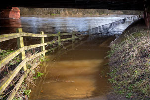
I approached the point where the cycleway went under the A723 bridge
I was disappointed to see it deep down under the bridge and totally
flooded as it passed under the bridge. It was extremely deep and
probably almost a metre.
Flooded cycle track
There was another cycle route heading up to
the footpath on the A723. It was up steps but to the right was a
concrete channel with a groove in presumably to help wheel bikes up.
I found it very helpful. I cross the Clyde on the road bridge then
wheeled my bike across to head back south. There was a connecting
path to the flooded path I'd seen earlier and I followed it down. I
could see the path had been flooded due to it being covered in sand
and mud in places. It is here that the River Clyde and River Avon
join and as I continued I can came to another flooded stretch but
this was about 20 cm deep so I cycled through.
I continued on through a Riverside Park area and eventually came to
a nice bridge taking me over the River Avon. It took me steeply up
into open park land where I could see the important looking house of Chatelherault
ahead with one of those memorial silhouettes on the way depicting
David Livingstone, Sir William Wallace and Robert Owen. Eventually I
reached the main A72 road and turned right towards Larkhall. It was
a very busy road so I continued along the footpath as far as I
could.
David Livingstone, Sir William Wallace and Robert Owen
Eventually I reached a cycle track where I could leave the
road and head into a park area which brought me to a housing estates
where I re-joined the road in Larkhall. I stopped at the Co-op shop
to buy some water. The weather looks threatening rain as I left and
joined McNeil Street to head west on my continue ride. I descended
steeply down to Avon Water then crossed over the bridge and turned
immediately left up the narrow Millheugh Road.
Railway viaduct piers.
The road was in a bad state and masses of rubbish along the sides at
one point it looks like a whole lorry load of rubbish had been
tipped down the river bank. There was a steep climb up where I
crossed under the old abandoned railway viaduct and up along the
lane to a point where I'd hoped to camp. It was where the old railway crossed the road again
but as I looked in the field it was blocked off with barbed wire
fencing and extremely wet. When planning my route I thought this was
a possibility so I continued along the lanes towards Stonehouse
where I thought I could camp in the park area. As I approached I
could see the park which looked far too open and public for a tent.
On The descent to the river I came to an old track leading off left
where I could get my tent out of sight. It was far from ideal but I
pitched there anyway as rain was on its way. It was interesting to
see some tall stone columns which would have originally taken the
railway across the Avon Water Valley. Shortly after getting my tent
up the rain started and continued all through the night.