Lots of heavy rain overnight but by
morning it had stopped, though the sky was still full of cloud. I
made a coffee and turned on the radio to hear the terrible news of a
bomb being set off at Manchester Arena killing around 22 people
including children. Also around 50 people have been injured.
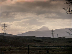
Distant view of Schiehallion
Apart from getting over the climbs my main objective today is to
photograph Schiehallion from the west to illustrate its unique
profile. The weather reports had forecast warmer weather but as I
set off it was still only 5 deg C. away in the distance I could see
Schiehallion just below the cloud so I took a long lens shot before
setting off. I headed east riding easily along the flat and then
enjoyed the long descent down to the Bridge of Gaur.
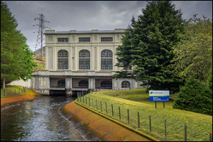
Power Station at Loch Rannoch
The recommended cycle route is along the south shore of Loch Rannoch
but I continued along the north shore hoping to get some views of
Schiehallion. I wasn't disappointed and managed some decent views of
the mountains on the way.
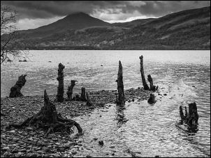
Schiehallion across Loch Rannoch
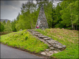
I reached Kinloch Rannoch and turned right to follow the minor
road to the war memorial. I stopped here briefly to walk up to the
memorial which lists men from the Great War. The structure is a tall
stone cone shape and unlike any I have seen before.
War Memorial at Kinloch Rannoch
I turned
left and followed the minor lane which is called Schiehallion Road.
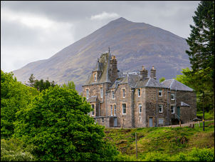
As I cycled along I saw an impressive Innerhadden house with the
mountains behind it so I stopped to take a photo of this unique
view. Having driven along this road I knew there was a climb up
ahead. There were many road markers saying the local roads were
closed on Sunday morning the 21st May for a cycle race. As I started
the climb there was still graffiti on the road as this is where the
cyclists came.
Schiehallion & Innerhadden House
Near the top of the first climb
The climb was relatively straightforward and I
managed to ride the whole way up without any problems. Over the
summit I was on the road I had walked along 2 weeks ago when
climbing
Schiehallion.
I reached the B846 road and turned left to climb slightly before
stopping to view Schiehallion from the East.
Schiehallion from the east
The view wasn't as
impressive as earlier but I took a photo anyway. I then enjoyed a
long descent to the Power Station at Tummel Bridge where I stopped
to photograph the impressive tall building. Passing through Tummel
Bridge I wheeled my bike over the Old Bridge which is now bye-passed
by a more recent one. As I crossed to the other side I became
concerned when I saw a road closed sign for the road I was heading
for.
Tummel Bridge Power Station
There were many construction vehicles as the road was being repaired
and resurfaced in several places. I set off anyway and decided to
wheel my bike to see how things went. I passed some men digging out
the verge edges and further on a roller was finishing off the
surface over a bridge.
The old Tummel Bridge
The old Military Road to Trinafour
I waited until he had passed over
then continued and was thankfully on a clear road again. I turned
right at the next junction to head over the pass to Trinafour. It
was a very long steady climb through the forest but was not
particularly steep at any point so was not too bad. The weather
continued cloudy bright as I climbed over the summit and then down
the long descent to Trinafour.
1730 Military Bridge
I turned left at the bottom to start the climb of my third pass.
Just before the start I noticed an old bridge on the left and
stopped to have a look. It was on the network of military roads
constructed between 1724 to 1740 under the command of General Wade.
This bridge was built in 1730
1730 Military Bridge
It is now a footpath over the top and was a lovely green grass area
that was freshly mown. The climb started as a few sharp switchbacks
and I doubted I’d be able to ride the whole way. When it got to the
steep part I got off and pushed though it turned out I could have
ridden it as it was a relatively short steep stretch. I managed to
ride up the next long stretch without any problems and then a sharp
left bend took me steadily up to a small loch.
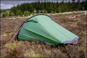
Camp 2 north of Trinafour
The weather brightened a bit as I
continued to the summit of the pass. My planned camp was supposed to
be in the Blair Atholl region about 10 or 15 miles ahead. I was at
an altitude of 442 metres and had great views so considered stopping
here to camp. The main problem was getting water and even though the
road had a ditch next to it with running water it was full of
rubbish thrown in by passing motorists. Fortunately over the fence
was a pine forests and an area has been flooded by the recent rain.
There was sufficient water overflowing for me to gather it in a pan
and top up my water bottles. I found a spot a few metres off the
road to pitch my tent in the heather. It was a little windy and
occasional patches of sunshine. This was ideal for getting the tent
dry.