For the first time in a long time I have decided to start a bike
packing trip straight from home. I set off at 6:50 a.m. under a
clear sky heading south east towards Manchester. It was clear and
cold and just above freezing when I left. I rode along the A6 road
and headed through Chorley and Adlington then down to Walkden where
I left the road to join the Salford Cycle Track. It follows the old
railway and is a well surface track which was great to ride on.
Unfortunately at the end I left it and followed narrow lanes &
streets to join another track which was in a worst condition.
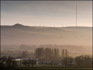
Rivington Pike & winter Hill
I
continued into Manchester city centre but my planned route crossed
the River Irwell was by a new footbridge but when I arrived I
couldn't get to the bridge because of a building site blocking the
access. I cycled around the roads to the Museum of Science and
Industry and then followed the streets to another area that was
blocked off by a building site. Considering this is a National
Cycleway route 6 and is blocked in two areas this is bad management.
Around 10 am I reached ASDA and called in briefly to buy some hot
cross buns for 75p.
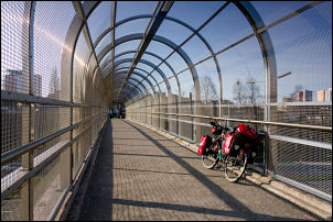
Easy road crossing
I left the city heading south and eventually
came to Alexandra Park which was a delight to ride through.
Alexandra Park (named after Princess Alexandra) was opened to the
public 6th Aug 1870. It served as an oasis away from the smog of the
city and "serve to deter the working men of Manchester from the
alehouses on their day of"
On Liverpool Road, Manchester
Alexandra Park drinking fountain
The Mayor of Manchester said "I do not
forget that it is a park for the people. The people have made it;
the people have paid for it; and the people will use it." The
drinking fountain was gifted to the park in 1876 by the Band of
Hope, a Temperance movement at the time. It was cast be
Andrew Handyside - Ironfounders. They also made bridges, piers and railway
stations. In 1879 they began to manufacture post boxes.
For the next several miles I was following unsurfaced dirt
tracks and some stretches taking a lot of negotiating. As I
eventually approached Hadfield I was thankfully able to leave the
rough and puddle filled tracks and join the road. The bad state
of the cycle tracks to the south east of Manchester were made even
worse by the proliferation of bags of dog muck which have been
dropped all over the place including the main roads.
Fallowfield
I
continued up into Hadfield and joined the track following the line
of the old railway up Longdendale. The surface was relatively easy
riding and I stopped by a bench to admire the view across the
reservoir. The weather continued fine and sunny even though it was a
little hazy.
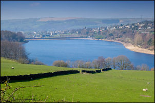
Mottram
The track eventually reached the road which I decided
to stay on even though the cycle track continues on a higher level.
The road was quite undulating until it reached the damn for the high
Reservoir which I crossed and stopped briefly before joining the
main road. I was then on the A628 Woodhead Road which carries a
considerable volume of heavy goods vehicles and is very dangerous
riding because there is no footpath or cycle track.
Valehouse Reservoir
Fortunately I
was only on it for a couple of miles before leaving to turn left up
the minor A6024 road. This is the long climb up to Holme Moss and I
have never driven or cycled up it before. The first part was
pleasant riding even though it undulates quite a bit.
Woodhead Res overflow
When I reached the split in the valley I turned left and headed up a
very steep hill which was beyond my capabilities with a fully loaded
touring bike. I had to get off and pushed and continued up the
steepest part until it eventually levelled off at a car park. I had
cycled around 48 miles at this point and was ready to stop and camp
but there was nowhere suitable for the tent even though a couple of
spots had a decent water supply. I cycle to the next steep section
where I had to get off and pushed and came to a small area on the
right which was an old quarry.
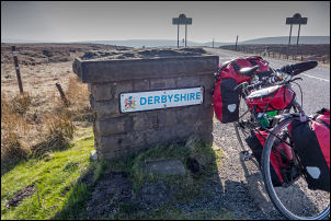
Leaving Derbyshire on Holme Moss
It would have been a good campsite but there was
no signal for my phone. I continued pushing up to the summit where I
stopped at the main car park which is where I left Derbyshire and
crossed over into the Holmfirth area. Some Rangers were there
clearing all the rubbish around the car park and putting it into
large bags. I stopped to take a couple of photos which included the
Holme Moss transmitter mast. The mast is 228 m (750 ft) high.
Holme Moss summit
It
had been quite warm in the sunshine as I pushed my bike up but as I
descended on the far side it became extremely cold as I was
freewheeling down. I reached a minor unsurfaced track on the right
which I followed as this was where I plan to camp for the night. A
sign said that it was closed further on for repair work but I had to
continue along it as there was nowhere else to camp. When I reached
the first stream crossing under the track I decided to camp here as
the water was good and I found a spot below the track where I was be
out of sight and hopefully not seen.