|
MEarlier in the week the weather
forecast for Friday was good. Varying intensities of rain during the
night made me think they'd got it wrong again. However, as I looked
out of the tent long before sunrise the crescent moon was just
rising, the stars were visible overhead and away in the distance
were the lights of Manchester. The temperature had dropped to 5degC
during the night due to clearer skies. I was on my way by 7:45am
heading up Wildboar Grain along an improving path. Higher up it
became stone slabs and then emerged on to the summit of Bleaklow
Head and a cairn surrounded by black peat. |

Bleaklow Head and cairn |
|

The Wain Stones |
All tracks then
seemed to disappear. I photographed the interesting Wain Stones then
wondered which way to go. There was no sign post anywhere so I had
to head out across rough moor following a compass bearing. Ahead I
could see the Hern Stones which strictly speaking aren’t on the
Pennine Way. The official route passes them a short distance to the
east. I checked them out before re-joining the official route and
some welcome stone slab surfacing. A stone way marker appeared,
similar to others, showing the Pennine Way only going one way. South
to North. The thought that someone would do it the other way doesn’t
seem to have occurred to anyone. As I descended the views opened up
and I had a good view ahead. The weather was much clearer than the
previous two days and in the distance I could see the vehicles on
the Snake Pass road and in the far distance the plateau of Kinder
Scout. |
|
Before reaching the
road I crossed a path called Doctor's Gate, which is also the route
of a Roman Road. An intriguing name. When I reached the tarmac of
the main road Kinder Scout still looked an awful long way off.
Fortunately the path across miles of moorland had been very well
surfaced with stone slabs. But this stretch was much better that
previous. On earlier stretches the rectangular stones had been
placed longitudinally, their short sides butted together making for
a narrower path using less stones. This also means that the reeds,
heather and grass soon grow over the stones and reclaims the ground. |

Doctor's Gate path, also a Roman Road |
|

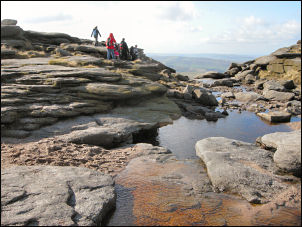
On Kinder Scout |
Along this stretch the rectangular
stones were placed laterally, their longest sided butted together.
It uses more stones but gives a wider and much clearer path. It was
a delight to walk on and the 2.5miles to Mill Hill summit passed in
no time. A short descent followed then a steep climb up a good
stoned path. I was now on the general plateau of Kinder Scout and a
good path took me along the edge. The boulder formations improved as
I proceeded. |
|
At Kinder Downfall
the River Kinder spills its water over the edge. There wasn’t much
water so it was a bit disappointing. Continuing south I met a man
coming the other way who was out for a day walk. He lived nearby and
was heading for a bus stop somewhere south of Glossop. We had an
interesting chat about the local area and continued our walks. There
were quite a few people out taking advantage of the nice weather. |
Kinder Downfall |
|

View towards Edale from the tent |
South of Edale Rocks I stated a steep
descent to a grassy area where I found a flattish area where I could
put the tent up. Nearby was a small stream with good water. |