|
The bus arrived on
time at 06:38am and the £1.80 single fare took me to Chorley bus
station. At the railway station I was due to catch the 07:01 train
to Manchester Victoria but for the second time in a week the train
arrived late. There was no information available on the display
screen because they were all out of action. The odd thing is that
train information was showing on the bus station. The train was
almost 10mins late meaning that my connection in Manchester was in
jeopardy. A further annoyance was when reaching Adlington the train
was stopped for over 5mins while the driver and another worker
sauntered along the platform to look at the fuel tank which then
announced was leaking. We continued but by the time we reached
Victoria I had very little time spare. I needed the Leeds train
which I could see was due to leave from platform one at 8am, and it
was 07:58. Running to the ticket barrier I asked the woman checking
the tickets where platform one was. She pointed vaguely in the
distance and said 'over there'. I ran as fast as I could but could
find no further platforms so came back to find the platform 1 sign
hidden behind an iron column and watched as the Leeds train pulled
out of the station. She could have pointed to the actual train when
I asked but that was too much trouble and would have involved her in
having to think. I returned to the barrier to point out that the
platform number wasn't visible but she was unconcerned. I suppose
the intelligence level is so low the railways find it difficult to
get anyone who is helpful and intelligent. |
|
The next train was due in 20mins but
it arrived on time and left 10mins late. I wonder how the train
network can function at all with this level of incompetence. I left
the station at 8:30am and reached Littleborough at 8:50. (SD 938
163) This is where I'd finished a section of the Pennine Way in
August this year and also where I'm planning to continue it south.
There was high pressure hanging over the northern UK but it didn't
mean sunshine just very overcast with little wind and slight
drizzle. I left the station by the underpass and crossed the road to
join the Rochdale canal for a while. It was pleasant walking along
the towpath but I soon had to leave it for the road to Blackstone
Edge. I was reversing the route off the hill the last time I was
here but this time as I climbed I could only see a low bank of
cloud. I reached the stone sets which form the old packhorse route
towards Sowerby Bridge and are annoyingly called a Roman Road. |

The Rochdale Canal |
|

The Aiggin Stone. |
Anyone with a shred
of historical knowledge knows it is not Roman. It was a steady climb
and quite warm in the still conditions. The climb ended at the
Aiggin Stone which was a medieval way marker. It is shown on its
side in Wainwright’s guide book but has now been re-erected by
Littleborough and District Lions. I turned right along a reasonable
path into thick mist. It was annoying not being able to see the
views from the Blackstone Edge traverse and also see the rock
formations along the way. |
|
The Ordnance Survey
column by the summit is perched on a large boulder. As I continued I
left the boulders behind and headed out across fairly desolate peat
bog. There were enough stretches of 'made' path to make the going
tolerable and not the ordeal it used to be. The mist began to thin
and I could see ahead. |

Trig point on Blackstone Edge |
|
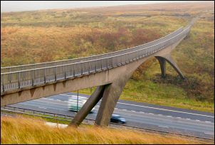
Pennine Way crossing the M62 |
I was approaching the M62
trans-Pennine motorway and I was almost on it before I could see it.
I crossed it at the famous footbridge which spans the deep cutting
that takes the motorway through. I passed the Bleakedgate Moor radio
mast and on to the A672 road and Lancashire Yorkshire county
boundary stone. |
|
Across the road I
headed out onto another path but soon came to a strange sight. A
man, young woman and camera man with large video camera on a very
large tripod. I asked them if they were making a film but the young
lady said something about training for a trip to the Sahara next
week. It all seemed quite odd so I continued. I came to a marker
stone showing the Oldham Way and Pennine Way and then across a misty
escarpment to Marsden Moor and Standedge. |
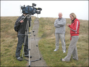
Filming on the moors |
|

Standedge cutting on the A62 |
I had veiled views of the reservoirs
below through the mist then emerged at the A62 and the Standedge
cutting which dates from around 1838 when the road was improved. The
1:25K Ordnance Survey maps change in this area. Annoyingly there is
no overlap making it rather difficult to plan the route in advance.
Fortunately the path is clear on the ground. Over the road is a car
park and a signposted track heading up on to the moor. On the summit
were nice views and a useful information board which describes the
features visible and information about the turnpikes. A long way
down, beneath my feet, are the Standedge tunnels carrying the
Huddersfield Narrow Canal dating from 1811 and railway tunnels, the
1894 tunnel still carrying trains. A stone marker showed where the
path leaves the track and heads over the hill to Black Moss
Reservoir. |
|
The reservoir is
very aptly named and the water is almost black, opaque and has the
appearance of farmyard slurry. As I descended to the reservoir I saw
a lone walker approaching from the Black Moss path. He stopped at
the reservoir and we chatted briefly. His asked if I had a map. The
reason for his query was that he had the map south of Standedge and
as he was heading north he was about to walk of it. His objective
was Todmorden to the north and didn’t have a map for that stretch of
the Pennine Way. That seems a serious planning oversight to me.
Fortunately I’d printed off the maps I’d need in 4, A3 sheets. I’d
just walked off sheet 1 which covered most of the route he needed. I
was now on sheet 2 so gave him the map he needed and we both
continued on our ways. I was in the general area I’d planned to camp
for the night so began the task of trying to find some decent water.
All the streams I’d seen so far of dark water and rocks stained red.
On Black Moss I found a flat spot for the tent and a stream with
less than the usual red stains but still far from clear. I had to
make do and give the water a good boil. |