|
Another very calm night except for the
constant droning noise of the wind turbines across the valley. There
was low cloud and before light I could see the welcoming glow of the
lights on the Winter Hill transmitter mast. As things became lighter
the wind turbines only had their lower halves visible below the
cloud. It made a strange sight as the blades appeared then vanished
into cloud. The still night meant that the tent was wet through with
condensation so had to be packed away wet. The path I was on is the
Rosendale Way and I followed it up to the head of the valley. The
low cloud had now lifted and a wide new road had to be crossed to
continue. The road was for construction traffic for the wind
turbines all around. There was one to the right which had a very
large crane parked next to it. The crane was dwarfed. |
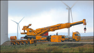
Wind turbine work. |
|

Message on the road to Ramsbottom. |
The path soon
became a track and the map calls it the Coal Road. As it descended I
got a good view of my next objective, the Peel Tower above Holcombe.
The relative quiet of the moors was soon shattered when I reached
the main A680 Rochdale Ramsbottom Road. The cars drove noisily by as
I descended towards Ramsbottom and thankfully took a minor road off
left down to the Bury Old Road. I was still on the Rossendale way
and continued my descent down a footpath until I came to another
main road. There wasn’t a stile but two high stone slabs partially
obstructing the way. It’s OK if you are a thin walker but it is
impossible to get through with a pack on, or if you are overweight.
I took my pack off and found I still couldn’t get it though the gap
so had to lift it over the adjacent wall. It seems the local
footpath inspector is either incompetent or dead. Crossing the road
I followed another path down to the River Irwell to emerge on the
busy A686. One advantage of walking through an urban area is that
there are shops and some that sell food. Across the road was one
selling full breakfasts and I was tempted but decided to continue
further into Ramsbottom. |
|
At the cross roads
I looked into a newsagents and saw the only consumables they sold
were chocolates and sweets. Fortunately I spotted a shop across the
road selling various hot sandwiches so I stopped for a delicious
danish pastry followed by a hot bacon balm cake. With a belly full
of bacon I set off up the minor road to Holcombe. It was very steep
so I took it easy. It’s a while since I’d seen handrails on a road
side but I doubt many people would know what they’re for. At the top
I took the track towards the Peel Tower access road and then
followed the footpath sign. It headed directly up the hillside and I
could see the tower top appearing tantalisingly ahead. |
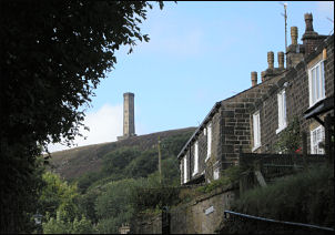
Holcombe Peel Tower. |
|
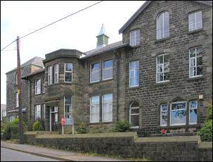
Crowthorn School |
I took the access road for the final
ascent and arrived to find some people already there. I stopped
briefly and carried on north to Harcles Hill. The map shows a path
heading to the west but it turned out to be OS fiction. After
crossing some very rough moor I came to a faint path heading north.
I reached the descent path from the Pilgrim’s Cross and descended to
the path around Holcombe Head. Fortunately the red flags weren’t
flying to signify target firing. After Laneshaw Head I started the
descent to Edgworth. I stopped to look across the valley to my next
objective, the moor above Turton. At the bottom of the road is
Crowthorn School, a building with quite a history to it. |
|
Continuing my
descent I came to Edgworth and the cross roads. I stopped briefly to
sample an ice cream cornet from a shop then continued down to Turton.
Over Bradshaw Brook I climbed to the right turn to Turton Tower. |
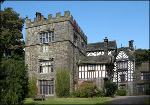
Turton Tower. |
|
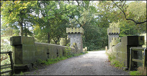
Magnificent Railway Bridge. |
I had a quick look before heading over
the railway and its magnificent bridge with a castellated viewing
tower. Above the bridge I turned right to follow the Witton Weavers
Way then turned left up the hillside. Above a barn was a spring and
pipe issuing into a plastic container. I stopped to collect water
and continued upwards. The path eventually took me to the summit of
Cheetham Close and the trig point where I pitched my tent. |