|
It was a very calm night but not
particularly quiet. Edge Lane, the road past the farm, is a dead end
but services quite a few properties so cars were coming and going.
Even the early morning was noisy. It was still dark when I put some
water on for a brew at 5am but I hadn’t been up long before the
first cars were about. I was packed up and on my way by 6:35am and
it was nice to be able to leave my rubbish in a bin outside May’s
shop. I usually have to carry it all with me. |

More company on the trail. |
|
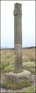
Reaps Cross |
I headed NW along
Edge Lane shortly after first light. The tarmac ended at a property
called Egypt and then I was on a moorland track. I left it for a
footpath to Reaps Cross which has been restored. The cross base
would be original but the stone column was in too good a condition
to be original. It stood quite high. I kept going in the approximate
direction the map showed but there was no sign of a path on the
ground. It was rough going for over a mile until I saw the first
path marker post. I followed them to Noah Dale Water where there was
an old breached dam. The path then took a direct line to Hoof Stones
Height and the path was reasonable and easy to follow. At the summit
is a trig point and fairly good views. |
|
There was a thin
veil of high cloud which was settled and kept the sunshine away but
it made for good walking conditions. The map doesn’t show a path
down to the Long Causeway road but one was signposted near the trig
point. It was faint but I followed it for a while before it dwindled
to nothing. There were some nice rocky outcrops to improve the
views. After a laborious descent of deep rushes and squelchy bog I
reached the road. I wanted to follow the path down Pudsey Clough but
the map showed a long diversion to get to it. I decided to brave the
intervening continuation of deep reeds and swamp to go the direct
route. |

Derelict industry at Pudsey. |
|

Reaching the A646 under the railway. |
I reached the line of the old road at
Stiperden House Farm which was quite interesting as most of it had
been washed away due to neglect but some of the old stone buttresses
were visible. I picked up the descent path down the valley and
followed as best I could but some stretches were very indistinct. At
Nant Wood I came to a track and the way was much easier to follow.
The views down in to the valley were impressive but depressing as
the old mills and chimneys could be seen in an advanced state of
decay. A sign of past prosperity long gone. I reached the main road
at Cornholme and turned right for a while. I hadn’t had much for
breakfast and was beginning to feel peckish. |
|
I was glad to come
across a small shop selling chocolate bars and sandwiches. I had a
very early lunch sat on the bench by the bus stop before following
the track up Heald Moor. The map calls it the Burnley Way but the
way markers are indistinct and anyone without a map would be
struggling. Eventually I came to a high level track which took me to
Thieveley Pike trig point. Below I could see the pub at Deerplay
Moor. I followed the track down to it and crossed over to follow a
track called Long Dike. It was not easy to follow as sections were
indistinct and too bogy to get through. I had to climb over the
fence on a few occasions to avoid getting my feet wet. The next mile
or so was a mix of paths and after reaching the summit at a trig
point I descended by various paths to Waggoner Tunstead Farm
building. I was now back in to a built up area and followed the road
down to the main Bacup Rawtenstall road. |

Slab wall near Hugh Mill. |
|
Across the valley
was the line of the old disused railway and the map showed a
bridleway following it. A minor road called Brandwood headed up to
the old railway line but it was impenetrable overgrown scrub so
there was no chance of following it. Further up was a lane that took
me up to the Hugh Mill area. The first part was a track then a green
footpath down to the road. I turned right for a short way before
turning off left up a steep track up the hillside towards Cowpe
Lowe. I was now on the Rossendale Way and continued along it through
old quarry workings. Overgrown spoil heaps were everywhere but now
it was deserted. Unfortunately not completely deserted as ahead was
another group of pointless new windmills that blight the landscape
and don’t even produce enough energy to cover the cost of their
construction. I followed the track to the site of the old property
of Fo Edge, the former home of the poet Edwin Waugh (1817-90) which
had been lovingly demolished by the local council in his memory!
Further along the path was Waugh’s Well, a stone structure around
the spring. The water was as clear as the spring I’d used at May’s
yesterday so I decided to make this my camp for the night. |
|
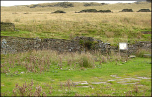
The site of the demolished Fo Edge. |

A period postcard shows Fo
Edge and the well
both together, which they're not! |
|
|

Waugh's Well. |
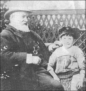
The Poet Edwin Waugh and one of his
grandsons |
|

Sunset and wind turbines. |
As I cooked my evening meal I heard
the noise of 2 mountain motor-bikes. They stopped at the well. After
a short time they began shouting. Then they shouted at my tent. I
emerged and asked what they wanted. Realising they’d got more than
they bargained for the cowards rode off into the sunset. |