|
I caught the 08:14 bus to Preston then
to the Railway Station to catch the 09:27 train to Hebden Bridge. I
arrived on time and was on my way shortly after 10:30am. It was
overcast and warm but a very slight drizzle seemed to threaten rain.
Fortunately it didn’t last long and walking conditions were pleasant
as I joined the towpath of the Rochdale canal. |

Travelling through the Cliviger Gorge on the train. |
|

Hebden Bridge Railway Station. |
The weekend weather
had been generally good so far and many people were taking advantage
of it. It was nice to see so many people enjoying the outdoors. I
was heading west to pick up the Pennine Way route and was pleasantly
surprised to see how picturesque and interesting the few miles of
canal were. There were several locks and interesting overflow
spillways on the line of the towpath itself. All too soon I reached
the bridge where the Pennine Way crosses the canal and I had to
leave. |
|
On the road there
was a Mountain Rescue land rover and several people milling about.
There was no urgency about things so I assume it was some sort of
exercise. I crossed the main road and headed up the track under the
railway bridge. A stone cobbled path headed straight up the hill to
meet a track at Nabby Nook. Up ahead I could see a couple of walkers
and by the time I’d reached the site of the demolished Mount Olivet
Baptist Church I caught up with them. |
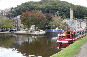
The Rochdale Canal in Hebden Bridge |
|
Steep climb up to the Mount Olivet Baptist Church. |
We chatted about the route and they
took the official way while I took the Wainwright route via Dove
Scout and Lane End Dam. Being more of a track than footpath there
were a lot of mountain bikers around. At Winter’s Lane I was on
familiar territory and joined the path I’d walked last month, though
now I was heading north and not south. There was a bit of a breeze
as I walked over the fields to Badger Lane. I looked ahead and
behind but could see no sign of the couple I saw at the old church
site. Over the summit on Pry Hill I could see High Gate Farm, the
day’s objective, ahead. |
|
A narrow path
between stone walls took me down to Colden Water and the fascinating
stone footbridge. A path took me up the valley side to the next road
which I crossed to follow a path to High Gate Lane and a sign saying
‘May’s Aladdin’s Cave 200 yds’ I turned left to the farm and it’s
shop and small camp site for walkers only. On the right was the ruin
of the old High Gate Methodist church which was demolished in the
late 1960s. At the shop I got permission to camp, which was free,
and later spoke to May about the old church. She had an old photo of
it which I photographed.
|

Some company on the path. |
|

High Gate Methodist church c1965.
The driver is David Collinge. |

The same view today. |