|
|
|
The temperature continued to drop during
the night. It began to snow and I’d inadvertently left a bit of the
top door zip undone. I woke briefly to discover a pile of snow
accumulating by my sleeping bag. I scooped the snow away but found
it difficult to do the zip up as it was frozen solid. In the morning
the water bag had frozen as well and took some emptying when packing
up. I had to crush the ice as best as I could and shake it out of
the filling hole. The temperature dropped to -7degC. Snow and cloud
greeted me when I woke. Yesterday’s decision to continue was right.
Fortunately the cloud lifted a bit and the snow stopped. |
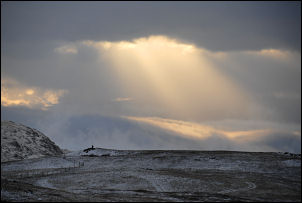
Sunrise from the tent. |
|
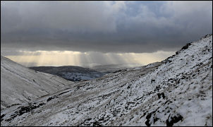
On the climb of Harter Fell. |
I was on my way
before 9am but the fierce wind and cold made it difficult going.
Nearing Harter Fell summit the snow began again and was extremely
painful on my face in the wind. At least I had some good but gloomy
views along Haweswater. It was treacherous underfoot due to ice
coating the rocks. Before the descent to Nan Bield Pass I fitted my
ice studs to the soles of my boots. It would have been very
dangerous and difficult without them. There was a thin coating of
snow everywhere and even though no sun broke through there were nice
views. The main problem was the wind which made the going very
difficult. |
|
Just standing up was a problem so trying
to walk as well was even worse. The stone windbreak at the summit of
Nan Bield Pass gave some very welcome shelter. Then it was steadily
up again towards the path to Mardale Ill Bell. I was glad of the
visibility as finding the right path in mist can be a problem. The
narrow path that follows the contour above Bleathwaite Crag is
rather difficult in high winds as there is a considerable drop
below. On the line of the old Roman Road it was still difficult
going in the wind and I decided against going over the top of
Froswick and took the minor path across its western flank. |
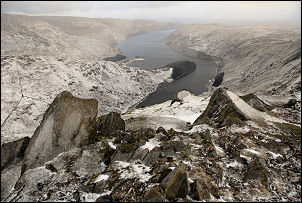
View down to Haweswater. |
|

Distant view of Windermere from Ill Bell. |
I went over the
summit of Ill Bell only because I couldn’t find the lower level
detour in the snow. My planned pitch was on Rainsborrow Crag but the
high wind made me think again. On the summit of Yoke I decided to
continue down to find shelter from the wind. I abandoned my original
plan and continued descending until a reached a wall with some
shelter and a water supply. At least I had a view of the Distant
Howgills as I pitched the tent. |
|
|