Yesterday’s clear sunny weather had gone and was now overcast cloud.
I packed up camp and was away before 7 a.m. then started by wheeling
my bike across the field and onto the lane. I free-wheeled down and
along Croydon Road to the village of Arrington. Here I met the main
A1198 which is also the old Roman Road of Ermine Street. Across the
road the cycle route goes into Wimpole Park. The main gates were
closed but the side gate allowing cycles through was open. I rode
along the track through open countryside and eventually reached the
south approach to Wimpole Hall. I stopped briefly but it didn’t look
very impressive or even occupied. I continued along the track
passing a large car park area so presumably events are held here. I
reached the road and turned right and on to the main A603. I turn
left for a short way along a cycle track and thankfully turned right
and off the main road into the village of Orwell.
As I cycled up the main street and up a hill at the north end I
reached a junction by the church. The lady vicar was just coming
out. I turned right but kept a close eye on my GPS as I would soon
cross the Meridian line of 0 degrees. I had just left the village
and on the right was a building which looks like a head office of
some kind. By the entrance was a bench and 2 concrete bollards by
the road.
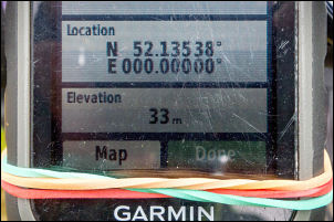
Crossing the meridian
I reached the zero longitude at one of the bollards and stopped for
a few moments. It seemed odd that a business that has the Meridian
running by its entrance hasn’t marked it in some way. I continued
east to reach my next objective which is Cambridge. The road was
very pleasant riding but fortunately there was a lot of fast
commuter traffic. I rode through the village of Barrington and then
into Haslingfield to take the road north.
On the meridian
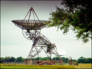
On the way I noticed several radio telescopes off to the left. They
were in the middle of fields and didn’t have access roads so where
presumably remotely operated. The map says Radio Astronomy
Observatory. I reached an old railway bridge and stopped on the
summit and could see radio telescopes both side of the road. There
were also a lot of cyclists coming the other way.
Radio telescope
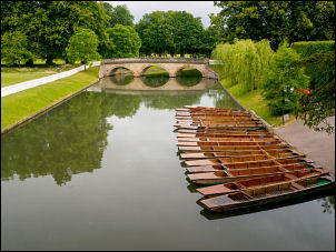
River Cam in Cambridge
There were so many it must have been an event on of some kind. I
reached the very busy A603 road at Barton and joined the main
commuter traffic towards Cambridge. For a while I was able to ride
on the pavement but some sections were nose to tail traffic. I
eventually reach the main road heading north and to the west of the
River Cam. I was hoping to see the Cambridge ‘Bridge of Sighs’ and
followed a path off the road towards the bridge.
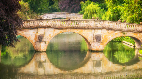
River Cam
The whole area to the west was fenced off and gates locked saying
the main entrance was from the other side of the river. It did say
the name of St John’s College by the road so I cycled back the way I
come and over Claire Bridge and through the streets of Cambridge.
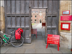
When I reached the entrance the sign said no public allowed in until
10 a.m. As it was only 9 a.m. I looked through the doors and asked
the lady at reception if it was possible to see the bridge. She said
I wasn’t allowed in yet and even at 10 o’clock I would have to pay
£10 access fee to go through the college grounds and see the bridge.
I decided I was neither going to wait or pay that extortionate
amount.
To early to get in
She also said the only way to see the bridge was through the college
grounds. I gave up on the idea and moved on. I cycled through the
streets to reach the cycle track along the south side of the River
Cam. I followed it to a park area where I left the river and joined
the main A1303. I was fortunate that there was a good cycle track by
the road and I followed it out of Cambridge in the direction of
Newmarket. I stopped at a shop to buy some doughnuts which I ate
outside in order to give me some energy. The road continued and
crossed over the main A14 and joined a parallel road the A1303 which
I followed towards Bottisham. The cycle track was easy going
but at Bottisham it degenerated to a very rough stretch of tarmac
being reclaimed by the surrounding grass. It was totally unfit for
purpose and I had no option but to ride on the very busy and fast
road. I continued and only had one objective and that was too get
through the horrible road as soon as possible and reach Newmarket.
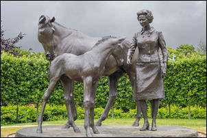
As I reached the main road into the town I noticed a new statue on
the left which had only been there since 2016. It was a statue of
Queen Elizabeth II by some horses and it was to commemorate her 90th
birthday. I was relieved to ride on into Newmarket where the traffic
was much slower and easy to negotiate. Near the top of the hill I
turned off to call in at the Morrisons supermarket to buy water and
a tin of something for my tea.
Queen Elizabeth II sculpture
Newmarket
I asked the lady if they had any tinned chicken curry and even
though she took me to where she thought there may be some there
wasn’t any and she said they may not have any. I found a tin of
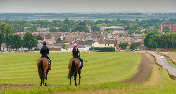
haggis so thought I’d give that a try. I left the town to head on
the minor road which runs due east and through an area of open land
where horses are trained. The map calls it Warren Hill and it was a
steady climb all the way to the summit. Over the top it was a very
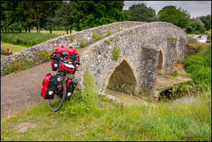
pleasant ride into the village of Moulton where I crossed over the
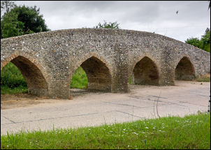
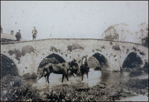
B1085 and down a narrow lane to the old pack horse Bridge. It is a
remarkable structure and dates back to the 14th century.
Moulton Packhorse bridge
Moulton Bridge today
Moulton Bridge c1890
It crosses the river Kennet and is built of flints held
together with mortar. There was very little water running under it
as I wheeled my bike over. A narrow lane took me up the other side
of the Valley along a steady climb. It was fairly steep in places
but I didn’t have to go into bottom gear. I passed through the
village of Gazeley and continued northeast out into delightful open
countryside. I descended into the village of Higham which is quite
spread out without any kind of village centre. I had a quick look at
the war memorial as I passed then descended to the to the main A14
where I crossed over it by a bridge then headed north along a lane
out into open countryside when I reach the next right turn. I
continued along a narrow lane which is also the old Roman Road of
Icknield Way. I followed it through woodland until I came to a
crossroads at Davenham and then continued in the same direction and
also still on the Icknield Way up a steady climb. Eventually I
descended down to Lackford where I turned left onto the A1101 and
continued for a short way and crossed the River Lark then turn right
onto a minor road. I’d planned to stay here at a car park shown on
the map. The area is called Rampart Field and even though there is a
substantial car park there were no benches or seats. A couple of
cars were parked there so I left the parking area and wheeled my
bike across the grass and slightly uphill. It was still overcast and
it was an ideal spot for a camp. However, I made a major mistake. As
I’d seen the forecast saying cloud all day I pitched my tent in an
open area which was flat and good for a pitch. After I got the tent
up and started unpacking the clouds began to break and the hot sun
broke through. This made it unbearably hot inside the tent and if
the sun had continued I would have had to wait outside for many
hours. There was nothing for it but to take the tent down and move
it about 50m into the shade of a tree. It didn’t take too long and I
managed to correct my earlier mistake. I was very pleasantly
surprised to see that I had a good signal for my phone and 4G for
data.