A lot of rain during the night which had stopped by first light. The
nearby A70 was busy even through the night with large lorries
generally heading west. The morning dawned with very low cloud but
thankfully the wind had dropped. I joined the main road to head east
towards Douglas. I was concerned about the volume of traffic and
poor visibility. Obviously I had my rear lights on even though it
was daylight. The going was easy and I continued to Douglas where I
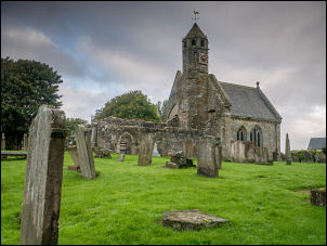
left the main road to have a look at St Brides Church.
St Brides Church
A sign on the gate said I’d need to call at a house across
the road to get in. I didn’t bother but walked through the graveyard
to look at the exterior. Half of the church was in ruins but the
other half was still used. I continued through the narrow streets to
re-join the A70. I continued east to the roundabout under the M74
having overshot my turn off up the A7078.
Turning off on to the B7078
I joined the road and
started up the long climb towards Abington. It was very nice to see
a decent cycle track by the road but as I continued over the summit
there were roadworks ahead for an access road to some new wind
turbines. Part way along the cycle track was a barrier and sign
saying it was closed. Common sense would say put the sign at the
start of the cycle track access. The earlier low cloud had lifted
and picturesque clouds moved through a blue sky. It was an enjoyable
and almost traffic free ride to Abington services. I crossed the M74
and turned towards the village of Abington which had a signpost
saying the highest village in Scotland. I was heading south on the
A702 which ran close and parallel to the M74. It was here I saw my
first cyclist since starting my ride yesterday. At Crawford I took
the road through the village and not the bypass though there was
nothing to see. Near Elvsanfoot I left the A702 and joined the B7076.
For a few miles I had a nice cycle track to follow though some
sections needed cleaning of undergrowth. I reached the M74 junction
15 for Moffat and turned off on to the minor lane towards Newton
Wamphray. I stopped at the turn off for something to eat and drink
and enjoy the sunshine. The narrow lane wound its way along and over
the River Annan. Some stretches had grass growing along the middle
of the road. At Newton Wamphrey I started to climb and I had a
better view of the surrounding countryside. The road undulated but
generally climbed up and eventually started to descend to the
village of Boreland. At the village hall I stopped to see if there
was an outside tap but couldn’t find one. Workmen were working on
the outside of the building and it looked as though they were
working on the rendering. My original intention was to camp here but
with no water I continued. A short way ahead was a man in a car by a
farm building. I asked him about water and he showed me a tap on a
farm building where I filled my 2lt water bottles. I continued along
the road towards Eskdalemuir and kept an eye out for somewhere to
camp. I had a steady climb for a mile or so but no signs of a
suitable pitch. The views were good, as was the weather. Eventually
as I started my descent I saw a small area of flat grass between the
rushes in a field. I wheeled my bike through the gate and pitched my
tent.