|
The rain eventually stopped and there
was an almost clear sky for the sunrise. As I packed my tent away
there were quite a few people out walking their dogs. I resumed my
ride along the cycle track and returned to the bridges I’d reached
yesterday. |
|
|
|
|
The old
railway station is now a cafe |
|
|
|
|
|
|
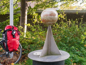
I pressed on to investigate the rest
of the inner Solar System. I reached Jupiter which even had the
large spot showing on its football sized globe. When I reached Mars
I was surprised how tiny it was, about the size of a pea. Earth,
Venus and Mercury were only about 100m apart. I met a man walking
and he told me the sun would be impressive. |
|
|
|
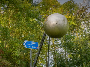
The sun
at the centre of the solar system |
|
|
Ahead was a bridge flyover of the A64
York by-pass. The large globe of the sun was on the other side and
silver in colour. A cycleway pointed towards York city centre so I
followed it across racecourses to join the road network and my
original planned route. I rode into York along the west wall then in
through the gate arch. I took the next right to ride parallel to the
River Ouse and had a quick look down by the river at a cobbled
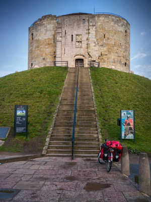
wharf. Back on the road I crossed the Ouse then saw the Clifford’s
Tower on top of a huge circular mound. |
|
|
I rode up to the base and noticed it
didn’t open till 10am. I walked up the steps and noticed the large
wooden doors were unlocked. I pushed them open and peered inside.
The staff were standing around and a young lady came forward to tell
me they weren’t open yet. She told me a few facts about the castle.
One I found very interesting one is the water supply is for a well
that goes down through the mound and into the ground below. The
lower part of the well was dug before the mound was built. I cycled
on through the central areas of York to the Minster Cathedral. |
|
|
A few shafts of clear sun came
through but they were so brief I kept missing them with my camera.
Leaving York I headed north to Strensall. There is an army camp
there and as I rode through could hear gunfire for quite a while. At
Sheriff Hutton was an interesting ruined castle but I couldn’t get
near it as it was on private land and protected by ‘private’ signs. |
|
|
Approaching Bulmer was a hill too
steep to ride up so had to push the bike. In Bulmer I stopped to
look round the delightful 11th century St Martin’s church. The
graveyard was loosely fenced off and sheep being used to keep the
grass down. I continued and soon turned left to head north towards
Castle Howard. |
|
|
|
|
St Martin’s church interior |
|
|
|
|
St Martin’s church graveyard
maintenance |
|
|
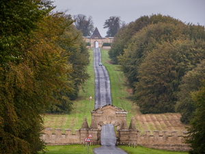
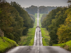
The road was straight and impressive
with a couple of gate arches ahead and large spire in the road
island. At the main entrance. I had a quick look but wasn’t allowed
to ride my bike towards the main house. I left through the car park
and continued north. It continued overcast and I was concerned that
it could start raining at any time. |
|
|
|
|
|
In Slingsby I
made a short detour to check out Slingsby Castle but it was lost
amongst overgrowth and a sign said no access. I continued north to
the main A170. It was fast and busy so I rode on the rough footpath
wherever I could. I was glad to reach Keldholme where I joined the
minor roads towards Hutton-le-Hole. The road was a steady climb for
the next few miles to Hutton where I stopped outside the museum. It
was very expensive to go in so didn’t. There were the usual
collection of tourists shops around so I soon set off again. I knew
I had a long climb ahead to my planned camp near the Lion Inn. I
took it steady and was thankful of a following wind to give me a bit
of help. |
|
|
|
Hutton-le-Hole Museum & tractor |
|
|
It was still very overcast and rain could start at any
time. Eventually the Inn came into view in the distance but just as
it did the rain arrived. By the time I reached the Inn the rain was
torrential and being blown by strong winds. I found some shelter by
the wall of the Inn then went in to ask where I could get water. Two
people were queued at the bar but nobody was there to serve them. I
waited but nobody arrived so I went outside and asked a man round
the back. He pointed me to a tap on the wall near the entrance. The
last time I was here was 1980 when walking the Coast to Coast route
with Charlie. Then we camped by the Inn but now there was a no
camping sign. I found a patch of ground to the north which was out
of sight of the Inn so camped there. The rain eased then started
again and was on and off through the night. |
|
|
|
|
|
|