|
A very calm night but it did feel a
bit cold just before dawn, even though the temperature was 4degC and
nowhere near freezing. The moor I’m camping on is popular with
walkers and dog owners and the huge amounts of dog muck everywhere
back that up. There was even someone walking nearby as I packed my
tent up just before 07:30am. I rejoined the Bingley Road and
continued down, over the cattle grid and on to Glovershaw Farm where
the path heads right up the Golcar Farm access track. As I passed
the buildings I realised it was some sort of dog place as it didn’t
seem like a working farm. The path crossed fields and up to Otley
Road where I turned left and continued to an interesting looking pub
called Dick Hudsons. |
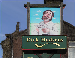
Dick Hudsons |
|

the Twelve Apostles |
|
Here I turned right and left the road
to follow a path on to Ilkley Moor. As I got higher I came to a
length of path that was paved with the stone blocks I’ve seen
elsewhere in Yorkshire. After the stones the path became quite muddy
but dried out as I got higher. I reached a stone circle called the
Twelve Apostles but the stones seemed rather hap hazard and may have
been messed with in previous years. A short way ahead I came to the
edge of the high moor and had a good view of Ilkley below. Before
descending I noticed another small collection of flowers and
memorabilia marking some sort of grave or memorial. The descent path
had wooden boards to span some of the wettest bits then below I
noticed a white building. I decided to check it out. It turned out
to be the While Wells Bath house but also had a cafe attached. I
ordered a £1.40 pasty to eat outside in the sunshine. I had a look
in the bath house and the excellent information boards. I was
surprised to hear that they are open all the year round. |
|

While Wells Bath house |
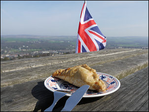
£1.40 pasty |
|

Rombald's Well behind the bath house. |

The Well today |
|
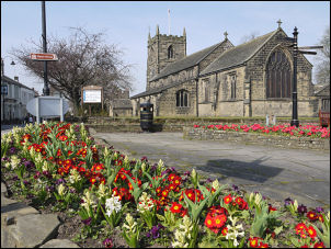
Ilkley in bloom. |
Then I descended to
Wells Road and down in to Ilkley. This is one of the nicer Yorkshire
towns that has kept its wonderful stone buildings. Much planting of
colourful flowers has paid off and not only the colours accompanied
me through the town but the flower smells as well. I left the road
at New Brook St and walked down the steps to Riverside Gardens which
is a memorial to the war dead. Today it is in sunshine and filled
with people enjoying themselves, thanks to those who died making it
possible. I followed the path nearest to the river so I could get a
good view of the fine old Ilkley Bridge. Bushes and trees obscured
the best of the view. The bridge is closed to vehicles but open to
pedestrians and cyclists. Once across I turned left to follow the
road round then took the right branch to head straight up the steep
hill. |
|
Near the top of the
steep bit I came to a newish looking church with three statues in a
grassy glade by the road. It always puzzles me why a religion wants
to depict a man being tortured and nailed to a piece of wood as a
form of execution with two other people standing by with pious
expressions on their faces. Well, if it makes them happy and I don’t
have to join in. A short way up the lane was a fine old stone way
marker saying 5 miles to Keighley with a pointing finger showing the
way. The road continued up until it levelled off but I continued up
along a farm track up on to the moor. Once on the open moor I wasn’t
sure of the right way to go. I continued along the track for a while
but soon realised I was going in the wrong direction. |
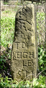
Keighley 5 miles |
|

Cup marks on Middleton Moor |
I cut off left and
soon found the right path. I was passing through an interesting area
of cup marked rocks but didn’t have time to search them all out.
Approaching the building of Wards End I turned off the indistinct
and boggy path and headed straight up the hillside towards Beamsley
Beacon. It was a bit rough in places but improved when the gradient
eased. On the way I thought I’d check out Riding spring which is
shown on the map. There is no spring of any kind now and I’ve found
this with several springs shown on the map. The Ordnance Survey
should show them as redundant. At the beacon there was a trig point,
a huge stone cairn and a group of people finding their mobile phones
more interesting than the view. |
|
I headed NE across
Beamsley Moor and hoped to find some water for a camp. There was
none to be had but the path and walking was pleasant. I kept going
until I reached a wall and a couple of gates. Through the pedestrian
gate was a couple enjoying a picnic in the warm weather. I turned
left to descend along a track. I soon left it to check out a stream
shown on the map. I found there was just enough running water in it
for a water supply and a patch of grassy ground nearby made for a
good campsite. |
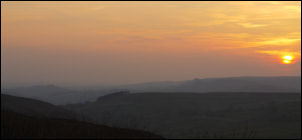
Sunset from the tent |
|
|