|
It’s a good job I got to the bus stop
a bit early as the first bus of the day was early. I reched Preston
around 06:10am and set off to walk across town to the Railway
Station. The amount of rubbish lying in the streets was terrible but
by the time I reached the Fishergate Lune Stree junction there was
paper rubbish right across the road. The 06:54 York train left on
time but I was only on it as far as Leeds. I was heading into
commuting time so by the time I reached Hebden Bridge then Bradford
it got quite full. I reached Leeds at 08:40am and set off to find
the Leeds & Liverpool canal. |
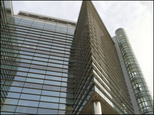
Leeds view above the basin |
|
New and old. |
I wasn’t sure of
the best way so I turned left out of the station and wound my way
round to a nice pedestrianised area of tall office blocks and an old
wharf area that I think is the river. An interesting pedestrian
bridge with a hoop supporting arch above was in the distance so I
headed for that, crossed it and reached the canal towpath. I turned
right and headed for Liverpool, but that’s not where I’m going. The
canal’s total length is 127.25 miles but I didn’t see any ‘miles to
Liverpool’ signs for quite a while. The interesting thing is that I
last walked this length of canal on Sat 12 March 1977 with Charlie
and I’ve brought a copy of the relevant part of the diary with me. I
commented then that the canal was clear enough to see the bottom.
That certainly wasn’t the case now. It was filthy. |

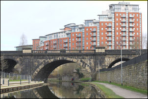
Interesting images across the canal |
|
|
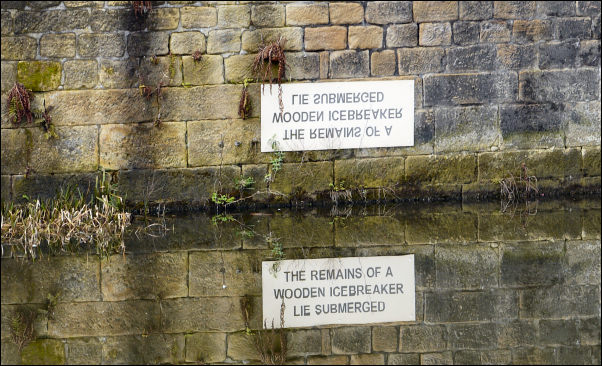
The reflection is needed to de-code the message |
|
I did make the same observations on
how impressive the Leeds buildings looked and also the variety of
bridge types along the canal. The weather forecast was good but thin
cloud prevented the sun breaking through at first. Some sunny
patches did break through from time to time later. At bridge 225 I
looked across the canal and noticed a sign on an old building which
looked to be in Russian at first. I looked again and saw its
reflection in the water which read ‘The remains of a wooden
icebreaker lie submerged’ A very interesting way to make people take
notice. |
|
Bridge 225 was
interesting as there were lights on the top and a stone building to
the right saying ‘Leeds Armley Mills’. Out in open country I noticed
a wire pole on the opposite bank with flowers on it and what looked
like messages like those appearing all over the place on roads where
there has been a fatality. Perhaps the trend is spreading to all
locations. Further on an old mill had been refurbished and looked
very impressive. Then I reached the view of Kirkstall Abbey which I
wrote about in my 1977 diary. I stopped for a while by the locks to
look at the abbey across the same ploughed field. The whole of the
towpath was in excellent condition and was stoned over most of its
length. |
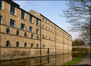
Nicely refurbished mill |
|

Crossing the River Aire |
In 1977 I commented
on the nice smell from Kirkstall Brewery but now I could smell
nothing. Further along the canal I asked an old man who was out
walking if knew of a brewery. He did but it was closed down many
years ago and now is student accommodation. The locks I was passing
were generally in 3’s and all going up. Many people were out
walking, running and cycling along the towpath. My planned camp was
on Baildon Moor so I had to leave the canal. Before Charlestown a
path leaves the towpath and leads down to the right and across a
footbridge over the river Aire. The green painted bridge was quite
interesting and a sign on it said it was erected in 1889. |
|
I reached the A6038
road, crossed it and headed up the hill and into Baildon. On the
climb up to the main roundabout I passed a building on the right
with a gateway and name plaques either side as a war memorial. At
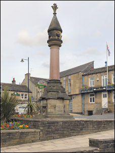
the roundabout I stopped for a short sit down by the stocks and had
hoped to buy some bottled water but the only shop selling water only
had small bottles. I pressed on to Bailon Moor. The traffic was
quite heavy as I walked along the road and the lack of a footpath
made the going uncomfortable as traffic whizzed by at high speed.
Occasionally I was able to follow tracks through the grass which
helped. I passed this place last Sunday and left a water depot
hidden in the grass just in case I couldn’t get any in the town. My
plan B paid off and I found the well hidden water containers using
my GPS. I climbed a short way on to the moor to find a flat pitch
and set up camp around 13:10. |
Passing through Baildon |
|
|