|
It rained most of the night but it had
stopped when I was packing away at 7am. I followed the minor path
off the summit and headed down towards Attermire Scar. I turned
right and joined the main path to Malham. I followed the path to the
gate where the route joins the road to Stockdale Farm. Near the farm
entrance the path leaves the road and follows a track up to the
fell. There were a couple of good springs issuing by the track on
the way. At the summit I passed though the gate and needed to find
the point where the right branch left the main path. There was no
marker but I soon found it. Ahead was an area of old mine workings
and spoil heaps. The grassy path started the descent to Malham,
gently at first but soon becoming quite steep. |
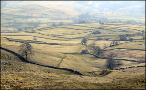
Descent to Malham |
|

Malham |
Taking it carefully
on the wet grass I descended below Pikedaw Hill then across fields
to join a walled lane at Butterlands Barn. Just outside Malham
village I came to a junction where I turned left to head for the
Bunkhouse Barn shown on the map. There were several people outside
it with rucksacks but before reaching them a small path to the right
took me to Cove Road which I followed into the village centre. I
wandered around for a while but couldn’t find a shop. I headed up
Goredale Lane and took it steady as there was a long climb ahead. A
brief descent took me down to the old and new Goredale Bridges.
There were some people up the valley that seemed to be working on
something by the river. I pressed on. |
|
The map calls this
stretch of road Hawethorns Lane but it then becomes the wonderfully
named Smearbottoms Lane. You couldn’t make it up. Eventually the
gradient eased and I was over the summit and walking on a gentle
descent to Middle Laithe farm. There was a rather nice bungalow by
the entrance then the track I followed had a wall to the right built
of massive boulders. I followed the green lane across flat pasture
then through a small valley and up through a gate and down to
Bordley House Farm. |

Boulder Wall at Middle Laithe Farm |
|
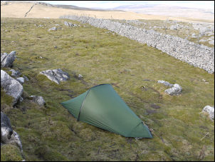
Sheltering from the wind |
I left by the main
farm access track but soon turned right to follow an indistinct path
across a sloping field. At the high boundary wall I climbed over
using the built in steps and started steeply upwards. My planned
camp was about a mile ahead but I had no idea what the water supply
would be like. As I reached the high point on the path I came to a
pair of cattle troughs with a plastic pipe coming from a spring. The
water flow was clear and steady so I decided to use it to top up
with water and camp nearby. I still had the 2 empty 2lt plastic
bottles I bought in Booths yesterday so filled them, strapped to the
top of my sack and headed up the small hill to my left. It was quite
windy on the summit so I found some shelter in a dip on the north
side. As I pitched the tent the rain started and there was quite a
lot of rain over the rest of the day. |