|
The weather forecast was grim but this
was the only time I had available to get away. I walked to the bus
stop through the correctly forecast rain. I arrived just after 6am
and the bus was due at 06:08. Parked outside the Bay Horse pub
across the road was a taxi with the engine running. After I'd been
waiting a while the taxi driver asked if I was OK. I told him I was
waiting for a bus and it looked like he was waiting for a customer
to appear from the pub. The lights were on and he went in. The bus
arrived 5mins late which was a concern as the train I'd planned to
catch left the railway station at 06:40 and the bus was due to
arrive at the other side of Preston at 06:28. 12mins was tight if it
was on time but now I doubted I'd make it. |
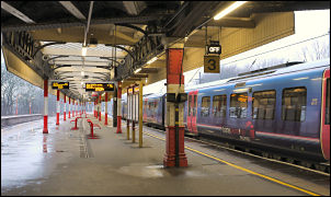
Lancaster Railway Station |
|
He was the first
bus of the day; there was nothing on the roads so how can he be
5mins late after driving just over 2 miles. Suppose incompetence is
the answer. We reached Preston 6mins late and I headed off across
Preston running as fast as I could with a 22kg pack on my back. I
didn't expect to make the train and I didn't. As I reached the
station entrance I saw the train leave exactly on time. They never
leave late when it would be handy. The next train to Lancaster was
the 07:15, which left on time. At Lancaster I set off across town to
the bus station. I had just enough time to catch the 7:45am Ingleton
bus which would take me to my fist objective, High Bentham. |
|

Market in High Bentham in the rain. |
When we got there I
was the only person on the bus. I asked the driver to drop me at the
stop nearest to the Railway Station. He said he didn't know where
the station was so dropped me at the centre of the village. We were
on time so I got off at 08:30am in pouring rain. A walked up the
road a while to a small market that was setting up. Across from them
was the road I needed, Station Road and a huge sign pointing to the
Railway Station. The bus driver would pass this every time he came
this way. I set off down the road looking in to some interesting
shops that were just opening up. After the station the road started
upwards towards Slaidburn. |
|
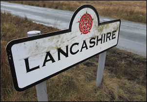
Crossing from North Yorkshire into Lancashire |

Crossing from North Yorkshire into Lancashire |
|
I met a man walking
down the other way. He asked me where I was heading. I told him and
we chatted a while before I continued upwards and in to heavier
rain. The map calls the road Thickrash Brow. I hope people living
along it don't have to use it in their address. I came to the cross
roads at Mewith Lane and stopped for a while as there was a metal
seat by the road. I continued up the road towards the higher mist.
Soon the distinctive outline of the 'Great Fourstones' boulder came
in to view. It was a way from the road so I didn't visit it. Where
the county boundary stone is for Lancashire and North Yorkshire, I
was approaching from Yorkshire, I left the road to follow a quad
bike track running parallel to the fence that denotes the county
border. The track was good underfoot but soon had to veer away from
the fence as Loftshaw Moss had to be crossed and it was impenetrable
to the mere pedestrian. |
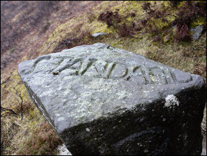
'Standard' Boundary Stone |
|
I was quite a way
from the fence when I was able to cross the moss where it narrowed
to a stream. Winding up the fell I eventually got back to the fence
at some substantial stone shooting butts. The fence then headed
straight up to Burn Moor summit. In the distance I could see the
trig point but before reaching it I came to a magnificent boundary
stone with inscriptions on all sides and the top. Unfortunately the
driving rain meant I couldn't photograph it to best effect. After
the trig point another marker stone came in to view, but not as
impressive. I was planning to camp below the East Cat Stones but
wasn't sure if there was a decent water supply there. Before getting
there I came to a small brook with water and some flat ground nearby
so decided to camp a little early. It was still raining when I put
the tent up but by mid afternoon the rain stopped and the cloud
lifted revealing Bowland Knotts and Pendle Hill in the distance. |