|
Considering the amount of cloud the
night before I was surprised how much the temperature dropped during
the night. I woke to the tent frozen and covered in ice. Outside the
sky was mostly clear with a few stars showing through. The sun was
visible shortly after sunrise around 06:15am but soon vanished into
thin cloud. The ground was still covered in frost when I set off at
07:10. I didn’t follow the fence line but took a SE line towards the
East Cat Stones which soon came in to view. Before reaching them I
passed another of the square boundary stones which seemed to be in
the middle of nowhere. The Cat stones aren’t very impressive, just a
low roundish cliff face. I was heading downwards in an easterly
direction to look at a Shooting Hut shown on the map. It wasn’t good
ground and I was on the north side of Outlaw Gill Syke trying to
avoid even more wet bog. |
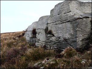
East Cat Stones |
|
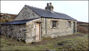
The Shooting Hut |
Eventually I saw a
short stretch of stoned track and the chimney of the hut I was
looking for. I reached the track and walked up to the hut. It was
stone built and quite substantial but all the doors were padlocked
shut. I peered inside through the window to see a simple interior
with a table and not much else. I retraced my steps along the track
and headed for Keasden Beck. I was heading for the Keasden Road but
the map didn’t show any paths to take me there. The track continued
north to another Shooting Hut but I had to leave it as that wasn’t
the way I was going. I reached Outlaw Gill Syke again and crossed it
easily. Up the other bank I came to an isolated barn then continued
to the deep valley of Keasden Beck. This is where things got
interesting. It was quite wide but not very deep. However, it was
too wide to hop across on stones and those that were exposed were
covered in green slime. |
|
The first bridge
was a long way downstream so the only way across was to wade. With
boots and socks off and a stick I found nearby I was soon across and
fortunately the water wasn’t as cold as I’d expected. A short climb
up and I came to Birk Knott farm where I walked through the yard as
inconspicuously as possible as the map didn’t show any public paths
nearby. I was soon up the farm road and on to the main Keasden Road.
I’d emerged where I’d wanted to be and I crossed the road to follow
a path towards Brow Side Plantation. As the path approached the brow
of the hill I looked in to an old quarry that the farmer had been
using as a dumping ground. It was full of a disagreeable mix of old
machinery, rusty wire fencing and all sorts of general rubbish. I
left and headed towards the bridleway running along side the
plantation. The gate to it had been tied shut and a stile over the
barbed wire fence removed. The lane had been reduced to a black mass
of mud and rushes by the farm vehicles, probably quad bikes, that
must use the route. Pedestrians have now to climb up the edge by the
barbed wire fence. The plantation had been partially felled and what
remained literally looked like a bomb site. I have no idea what the
owners can do with the land now. I came to Stoops Barn where the
track improved. The barn is some sort of Outward Bound building
judging by the layout. I soon left the track and headed along a
muddy path by more tree felled desolation. |
|
At New Kettlesbeck
farm I came to a road which I followed to King’s Gate to follow an
unadopted road towards Howith. I was very surprised to see an
Ordnance Survey trig point just over the wall to the left. I came to
Rouster Green and on to Langrigg and thankfully a decent road.
Walking along Cross Lane the weather improved and brightened up to
reveal a brief spell of sunshine. I enjoyed the easy walking along
the lanes and as I descended towards Settle and just before
Giggleswick Railway Station an elderly man was looking over his
garden wall and asked me to look at the wonderful display of spring
flowers in his garden. |
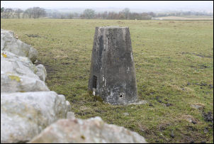
Trig Point in the field |
|
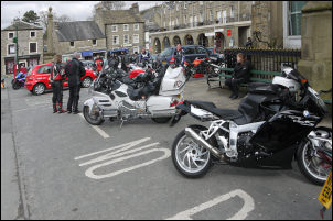
Bykers in Settle |
We chatted for a
while about the history of his house and the area in general. Each
local that passed by either by bicycle or quad bike waved as they
knew him. I kept on the road in to Settle and as it was Sunday
reasoned that the only general shop open would be Booths. So I
called there to by 4lt of bottled water. My planned camp on
Warrendale Knotts did not have a water supply so I’d need to carry
it up with me. I fancied a refreshing can of cider with my tea but
they only sold them it 4 packs and wouldn’t split them. So I would
have to do without. With 4kg of water strapped to the top of my pack
I could feel the extra weight so I took it steady. The middle of
Settle was a mass of motorbikes and their riders just hanging
around. |
|
The odd thing was
that they were mostly bald middle aged fat men. I headed up the
track then the green path towards Attermire Cave. On the flat
stretch I crossed the wall at a tall stile and headed steeply up the
south side of Warrendale Knotts to the summit trig point. It was
quite windy but I managed to find some shelter just below the top
and a small flat area to pitch the tent. At least I didn’t have to
go off and find water now. |
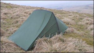
Camp on Warrendale Knotts |