Boyd's photo diary. |
|
|
|
|
|
|
|
|
Sun 29 Mar 2009
|
Withnell Fold Sports and
Social Club monthly walk |
|
Walked along
the canal bank to Dean’s at Withnell Fold then up to the Sports
and Social Club to meet the others for the Withnell Fold monthly
walk. The weather was clear blue sky and hardly any wind. Just
right for a brisk walk out on the moors. It was previously
decided to go further afield this time so the objective was
Great Hill, making this the longest walk so far. We left the
cricket field just after 1pm and headed up the road to Oakmere
Avenue, or Flag Lane as it is known locally. Continuing up to
Snape’s Heights there were great views to the west and across
Morecambe Bay to the dark outline of Black Combe 80km (50miles)
away. Stuart kept asking where Great Hill was but it wasn’t
visible from where we were. As we passed Pike Lowe Farm it was
possible to see initials of two of the Parke family. The first
H.T.P (Herbert Thomas Parke) and the second T.B.P. (Thomas
Blinkhorn Parke, Herbert’s father). Passing through the housing
estate we descended Withnell Fold Old Road to School Lane,
Brinscall. As we walked to the start of Well Lane I pointed out
to those interested where the Chorley to Blackburn railway line
used to pass over the road and also where Brinscall’s cinema,
the Regal, used to be. |
|

School Lane Brinscall and the railway bridge in the early 1900s |

The Regal cinema in 1949 |
|
At the top of
Well Lane we stopped for out first rest and another opportunity
to admire the views. The distant peaks of the Lake District were
just visible and also the distinctive flat topped outline of
Ingleborough 56km (35miles) away. There were many farms on these
moors in the 19th century but they are all now just ruins. The
last with a roof on is Ratten Clough and it was clearly visible
to the NE. Immediately adjacent was the ruin of Whittles which
is now nothing more than a few stones being reclaimed by the
grass and heather. The main group set off again at a fast pace
heading along the track to Drinkwater’s. I was walking with
Stuart and Janice and decided make a short detour to show them
the ancient Mear stone (Merestone) which is an old cross cut in a large gritstone boulder. |
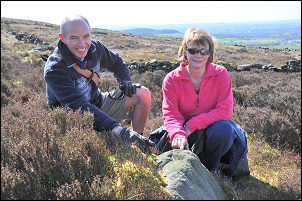
Stewart and Janice at the Mear Stone. |
|
We caught up
with the other and had another brief rest at Drinkwater’s ruin.
On the final approach is a brass marker on the wall. It is
called
Joe’s Cup and is a memorial to Joe Whitter who was an
endurance ultra-runner of the highest standard. He was a member
of Wigan Phoenix Running Club and died of a brain tumour in 1990
at the age of 52. His club placed the plaque there in his memory
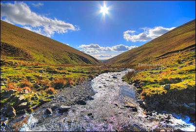
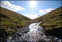
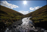
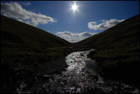
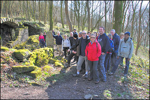
shortly after his death. Continuing along the path we reached
our objective, the summit of Great Hill. |
|

The group on Great Hill summit at 386m (1,266ft) |
|
We were still
blessed with great weather and were able to enjoy our
refreshments and admire the full panorama of views. Last week
Dean and Janice had spent a very windy camping trip in Scotland
where Dean was introducing Janice to the great outdoors. I knew
Dean had a compass so while I was in Birmingham last week at The
Outdoors Show I picked up a small Silva compass with a small
karabiner clip and gave it to Janice earlier in the day. We were
now at the highest part of the walk so as a light hearted test I
asked her to show me which way was north. She began to rummage
in her clothes and I was amused to see she’d clipped it to her
bra strap. She wasn’t wearing a rucksack and she said it was the
only secure place to clip it. I gave her 10 out of 10 for
initiative. We now began our walk back to Withnell Fold but
instead of retracing our steps we descended SE to a track by
Black Brook and on towards the ruin of Great Hill Farm. On the
way is a large boulder with an eroded Ordnance Survey bench mark
cut in it. It is shown on the 1894 map and shows a height of
1187.3ft above sea level. It was nice to visit the ruin of Great
Hill Farm as it is often missed, being off the main path. We
soon rejoined the main path and returned past Drinkwater’s and
along the track back towards Well Lane. We didn’t go all the way
but left it to turn left along a path towards Brinscall Pine
Woods. This was the path I’d taken Stuart and Janice along to
see the Mear Stone. As we passed the stone I pointed it out to a
few of the walkers before we left the sunshine and descended
into the pine woods. We’ve always called the area Brinscall Pine
Woods but the map calls it Wheelton Plantation. |
|
we reach the byre at Blackhurst |
In the early
1900s it was clear of trees and was a collection of buildings
and farms. The ruins are still there but all are covered in a
thick coating of moss. We passed the site of Liptrot’s Farm and
Leigh Place before reaching the area of Blackhurst which is a
very strange collection of ruins. The old cattle byre is still
there and in quite good condition. The entrance is blocked off
with metal grills to keep the vandals out. |
|
Further along
the track is where Heather Lea used to be. The ruins are now
completely overgrown but pat of one wall is still standing. It
was one of the last houses to be occupied and was still lived in
up to the 1930s. We are fortunate that some photographs of the
building have survived. |
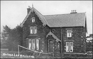
Heather Lea |
|
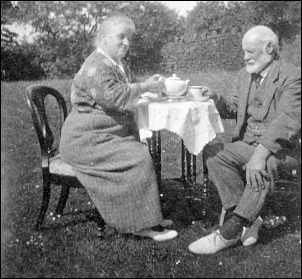
Mrs and Mr Moss having tea at Heather Lea |

Mrs Haydock and baby Bob Wiggans inside Heather Lea - 1927 |
|
We took the
path down through the woods to Lodge Bank then under the line of
the old railway and up past Brinscall Hall before heading off
across fields to School Lane and then on to Sandy Lane. Instead
of turning left to go directly back to Withnell Fold we took the
slight detour to the buildings of Boardman’s Heights and then
the path over Pike Lowe. The distant views opened up again but
they weren’t as clear as earlier. An easy downhill walk along
Oakmere Avenue took us back to Withnell Fold Cricket field, the
pavilion and very welcome refreshments. A fantastic walk of just
over 10 miles which was enjoyed by everyone. |
|

the route plotted from the GPS track. |
|

altitude profile from the GPS unit |
|
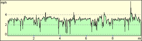
walking speed profile from the GPS unit
(the spike at the right is me running to catch up after stopping
for a pee behind a hedge!) |
|
Sat 28 Mar 2009
|
With the
evenings getting lighter I went for an early evening bike ride
round Mawdesley and Bispham Green then back through Eccleston.
It should be even lighter tomorrow as the clocks go forward
tonight. I was wearing my new cycling jacket with built in
flashing LED lights that I bought at the NEC yesterday. I’m not
sure what the motorists thought of me as I returned home in the
dark. A blinking apparition on wheels perhaps? |

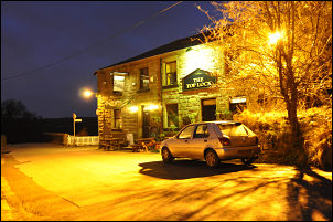
The Eagle and Child, Bispham Green. |
|
Fri 27 Mar 2009
|
Caught the 8am
bus to Preston to catch the 9:17am train to Birmingham. As usual
it was so late that the connection at Wolverhampton was missed
so I carried on to Birmingham New Street then changed for
Birmingham International. I walked across to the NEC and the
2009 Ordnance Survey Outdoors Show. I think this is the first
time I’ve had to pay for one of the lectures but I didn’t mind
paying £5.00 to see Doug Scott as he’s such good value. He was
in the World Theatre and it was full. His talk was mostly about
his SW face of Everest Climb in 1975 and also Kangchenjunga in
1979. The train journey home was much better as the trains
actually ran on time. |

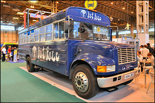
The Outdoors Show at the NEC |
|

Doug Scott gives another quality lecture with superb photos. |
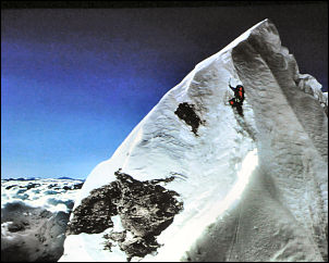
Doug's picture of Dougal Haston on the Hillary Step, Everest,
1975. |
 |
Truck on! |
|
Sat 21 Mar 2009
| While
watching the sunset from Long Rigg in the Howgill Fells I was
able to see its effect on the hills behind. |
|

Cause |

Effect |
|
Wed 18 Mar 2009
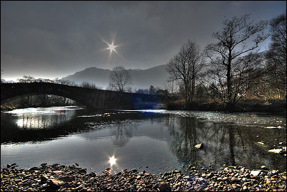
| I took 3 images of this scene
of the Grange in Borrowdale bridge, Cumbria but only used a
merge of 2 to get the best effect. There's no way I could ever
had got this result with film. |
 |
|
|
Thu 12 Mar 2009
|
|
Tue 10 Mar 2009
|
Sun 08 Mar 2009
|
I have been
playing with some HDR (High Dynamic Range) software from
Photomatix.
HDR Tone Mapping reveals highlight and shadow details in an HDR
image created from multiple exposures. My first test was the 3
exposures on the right and the image on the left is composed of
the best exposed sections from them. |
800asa 1.6sec f5.6 |
 |

800asa 1/3sec f5.6 |
| |

800asa 1/8sec f5.6 |
|
Fri 06 Mar 2009
 |
 |
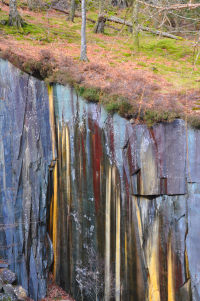
| I
returned to Borrowdale as I needed to call at Needlesports in
Keswick. During a short walk I had a look in Dalt Wood Quarry
and saw the interesting colours on the slate, presumably caused
by seepage from the fellside. |
|
Wed 04 Mar 2009
|
 |
|
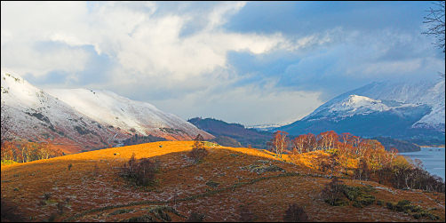
I was walking
through the wonderfully named area of Cummacatta Wood in
Borrowdale, Cumbria when I looked back to see a shaft of
sunlight catch the fell. Derwentwater is just visible behind. |
|
Sun 01 Mar 2009
|
The old Co-op shop in Withnell
Fold is being tastefully renovated and extended. The building
has an interesting history going back to the 1860s when it was
built. Joseph and Margaret Blackburn lived there then and their
eldest daughter Amelia was the school headmistress. |
|

The extension |

A painting of the shop in 1950 |
| |
At Top o' th' Lane Brindle a
plaque has recently been placed on the wall adjacent to the site
of the old Brindle Workhouse. The plaque reads:
Brindle Workhouse
operated on this site from 1734 to 1871.
Originally taken over from a catholic mass house, the
workhouse buildings were expanded and rebuilt housing
over 200 'paupers and lunatics' until 1816. It was
notorious for its severity and poor conditions even
among workhouses, and took paupers from over 80
townships across Lancashire. Around 1842 it was absorbed
into the Chorley Poor Law Union and effectively became
the town main workhouse until its closure in 1871 with
the building of the new workhouse at Eaves lane.
Among the thousands of paupers who must have passed
through its doors were -
W. Wamer of
Biston
Kitty Parker
James Warburton |
Alexander
Fowler
George Blackstone
Alice Bennison |
John Heywood
Jervis Heson
Timothy Cross |
Each was
a person with their own story.
For most of them, this is their only memorial. |
|

The wall adjacent to the Workhouse site. |

The plaque |
| |
|
|
|
|