I caught the 6:35am
bus to Chorley and headed for the Railway Station. The bus station
notice board for the railway station was working but the railway
station one wasn't. My train was the 7:15am to Barrow but when I
bought my ticket yesterday I was advised to change at Lancaster for
the Sellafield train, which was my final destination. Instead I
decied to continue to Barrow and wait there. In retrospect I would
probably have been better sticking to the original plan of waiting
and changing at Lancaster as they have some facilities. Barrow had
no cafe or proper waiting area. There were some seats in the
entrance foyer but all the doors were open and no heating. The 9:58
to Carlisle arrived on time and I enjoyed the slow ride along the
coast until I arrived at Sellafield station. It was about 11am when
I arrived and I set off walking in warm hazy sun.
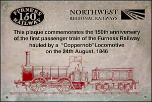
An interesting plaque in Barrow
Railway Station.
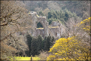
Calder Abbey.
I had a long walk
along the road before I got to the fells so I put my head down and
kept going. There were no proper facilities for pedestrians for
quite a while. The road was quite busy as it takes the traffic to
the main entrance to the Sellafield nuclear reprocessing plant. When
I got to the visitors entrance things improved and the final stretch
of road to Calder Bridge was on a footpath. I turned left at the
Church and followed a lane towards Cold Fell. My map showed the site
of Calder Abbey and as I passed I could see what quite substantial
ruins through the trees.
A man on a bike
passed me and further ahead he got off to walk up the hill towards
Abbey Flatts. He stopped at the top of the hill and I caught him up.
We chatted a while and it turned out that he was from Ennerdale
Bridge and was heading that way. I asked him if he knew anything
about the stone circle at Kiniside and he said it was a fake as his
Grandfather worked on it's construction in the 1920s. It was to
provide labour for men on the dole. He went on ahead and I continued
north as well until the road entered open fell. It was still warm
and sunny but a lot of haze had spoiled any views. I passed Cold
Fell and arrived at a road junction. I turned right down the track
and continued to the river Calder. I crossed the main bridge but
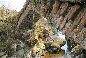
wanted to find another. To the north the map shows Monk’s Bridge.
Monk's Bridge
I wanted to have a
look at it before leaving the area so headed north a while. I found
it and had a close look but it wasn't signposted so isn't too
obvious. I was now looking for a tent pitch so headed east following
the small river of Caplecrag Beck up onto the fell. I reached a
prominent rocky outcrop which would’ve made a good pitch but there
was no mobile phone signal. I continued to a prominent high point
which had some ancient settlements nearby. There was a good view of
the Sellafield plant as I pitched my tent