A relatively short stage today so took my time with breakfast and
packing up. I was away by 8:25 a.m. and decided to check the rough
path to see if it continued to join the main cycle trail by the
railway. It was too rough to ride so I pushed the bike and was
pleased to find myself soon back on the cycle track. The earlier
clear sky was now veiled in cloud and there was still a chill in the
air but thankfully I had a tail wind as I continued east. I came to
the yacht club car park area where there is a picnic bench and waste
bin so I took the opportunity to get rid of my rubbish.
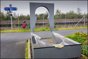
Compass on the trail
This is a route I've cycled before and it was extremely enjoyable
riding along the cycle path which runs parallel to the railway which
is one of Scotland's Rail routes that have been rebuilt from a
previously abandoned line. I followed the cycle track to the
outskirts of Bathgate where I left the official line and rode in to
Morrisons Supermarket car park.
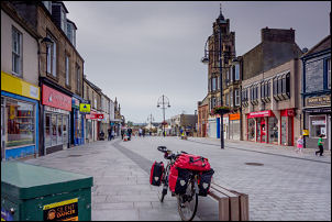
Bathgate
This is where I’d planned to leave the track and join the road for a
while. I rode up the street to the east and stopped briefly where
there was a pedestrian area and a seat. I had a banana and drink
before continuing east up Drumcross Road and a very steep climb. I
had to get off for a while and push my bike through the narrow
stretch which was far too steep to ride up. Once back on my bike the
climb continued but wasn't too bad and at least I had some nice
views in the clearing weather. A powerful car zoomed past me at high
speed and vanished into the distance. Once over the summit I enjoyed
the long descent which I was able to free-wheel down I knew there
was a sharp right hand bend at the bottom and as I approached
noticed three young men walking back up towards Bathgate. They
didn't look like the sort that would be out enjoying a walk. As I
rode around the right corner I saw the car that passed me earlier
was embedded in the stone wall. There was glass all over the road
and the airbags had gone off. Two young men were wandering around
the car and I can only assume they were in the front seats. Nobody
seemed to be injured so I passed the crash and continued down the
hill.
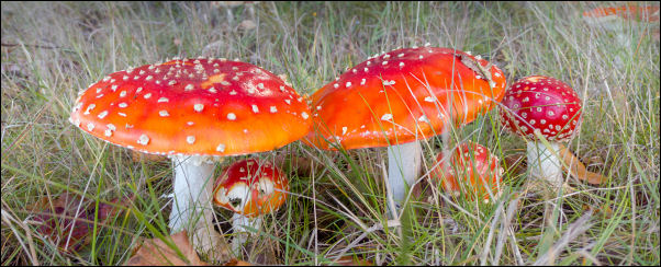
Fly Agaric by the A89 road
The Descent took me down to the A89 which is a very busy dual
carriageway. Fortunately there is a cycle track and after crossing I
headed west for a short while and then left to left the road to
climb up a narrow track which was also the cycle track and on the
line of the old original road. It crossed the M8 motorway and then
descended down towards Wester Dechmont. I turned into Woodlands Park
to see if there was any remains of the old Dechmont House I'd seen
on a 19th century map.
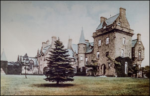
The original Dechmont House
I couldn't see any evidence of it but an old lady walking her dog
asked me if I was looking for something. She was very helpful and
said she’d lived there for around 40 years and remembers it when
there were no new houses. I walked back with her to her house where
she got her husband to find an old photograph of Dechmont House that
used to stand in the grounds across from hers. I took a copy photo
before thanking her and returning to the cycle track which headed
down into Livingston town. The track eventually emerged at
Livingston North Railway Station car park where I stopped for a
while to figure out the best way to continue. The Railway Station
look like a huge Meccano sets that had been bolted together from
steel girders. I couldn't see a cycle path sign anywhere but managed
to find a ramp heading up and followed it. It turned out to be the
cycle trail and went underneath Deans North Road and continued
parallel to the railway. The surface wasn't very good and it was
quite muddy in places. It continued due east and eventually emerged
onto Pumpherston Road where I stopped at a Scotmid Shop to buy
water. It was 65 pence for 2lt and I got two bottles. Across the
road was Uphall Railway station where I cycle through the car park
to find the continuing muddy track heading east. Eventually it's
emerged onto a rough tarmac road at an area called Roman Camp but
there was no sign of one. It looks like it’s just a small Industrial
Estate so I continued along the road where I came to the road just
south of the M8 motorway. I turn right for a short way and then left
to continue along a narrow lane through open countryside. It was
called Newhouses Road and at a left bend I carried on along a rough
farm track. This took me to a bridge over the Union Canal and once
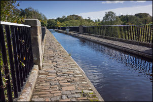
over I joined the towpath to head south to the Almond Aqueduct.
This is my planned camp for the night and I wheeled my bike up
through the woods to a spot I used the last time I was here. I
pitched the tent then set off on another objective for the day and
that is to find the grave of William Lynn. I walked over the
aqueduct and then down a narrow footpath to the access track to
Lin’s Mill.
Almond Aqueduct
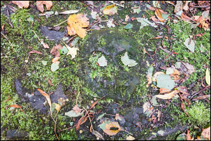
Grave
slab of William Lin
Moss and leaf covered Skull and Crossbones
The grave of William Lin who is reputed to be the last man in
Scotland to die of the plague (but many similar plague graves exist
from that year). The grave is marked by a slab with a crude coat of
arms, memento mori and the inscription "Here lyeth the dust of
William Lin right heritor of Linsmiln who died in the year of the
lord 1645". Apparently no-one would help his wife to bury him, so
she had to put his body in a sack and drag him into the woods for
burial. The adjacent Lin’s Mill is now in private ownership.
Another report states, that no neighbour would assist to bury him
and that his servant had to bury him in his garden where a Stone
with a rude inscription Still points out his grave.
===================
I was hoping this would give access to the grave but there were
security gates blocking access. I'd read that the Grave is high up
on a bank above the Mill so I returned to the towpath and climbed
over a fence to enter a field I'd also found a grid reference which
seemed reasonably accurate and had it into my GPS unit. As I walked
across the wet grass field I could see the location getting closer
and after stepping over a dilapidated fence the coordinates led me
to the large stone slab. They were extremely accurate. I had seen
photographs showing the stone slab with inscriptions and skull and
crossbones but now the whole slab was covered in moss and hardly
anything was visible. It needs a good coat of looking after. I
returned across the field and back to the towpath and up through the
woods to my tent. I was on the precise flight path from Edinburgh
Airport and every few minutes a plane would fly overhead as it set
off for a variety of destinations. With the Flightradar24 app on my
phone I could tell where they were going.