Heading back to Scotland for some cycle camping. Cycled to Preston
and reached the railway station in plenty of time for the 6:40 a.m.
Virgin train to Glasgow. The train was on time and I loaded my bike
into the compartment at the front of the train. There were already 2
bikes there so I had to strip the panniers off and hang mine from
the hook on the roof.
Preston Railway Station
As we left Preston and headed north I was treated to a lovely
sunrise view out of the window. The sun didn't last and we were soon
travelling under thick cloud. I reached Glasgow around 9:10 and it
was still heavily overcast. I left the railway station by the same
route as last time I was here and my first stop was outside Buchanan
Street bus station.
Glasgow Central
By the station on the pavement is am artwork of a clock on
legs. Set in the pavement is a plaque reading the Clyde Clock -
George Wylie 2000 gifted to the city of Glasgow by radio Clyde. I
continued along the road and picked up a cycle track that took me to
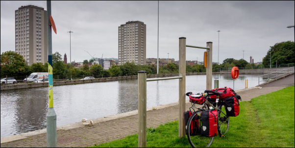
the canal at Port Dundas. On previous rides I have continued north
to the Forth and Clyde Canal. This time I headed east to a Canal
Basin I hadn't visited before. There wasn't much to see but it was
an interesting area as there were picturesque views of the high rise
flats reflected in the water.
Glasgow Central
Canal basin
For the next few miles I was heading
out of Glasgow in a north east direction along the main road.
Fortunately most of the way I was on a good cycle track. I
eventually reached the Muirhead area and left the busy main road to
ride on quieter ones. I rode through Muirhead and continued to
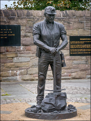
Moodiesburn where I stopped to investigate a memorial by the road.
It was to various mining coal mining disasters in the area and give
brief details of some disasters including the Auchengeich 18 Sep
1959 where 47 men died due to a coal mine fire 1000 feet down the
shaft.
Auchengeich Miner
There was an impressive bronze statue casting of a Miner with
extraordinary attention to detail including his miners helmet and
Oldham lamp and check lamp. It turned out that after erection the
original was stolen and the statue I was looking at was the
replacement. I continued along the road and left it to follow a
cycle track through a housing estate which took me to the outskirts
of Cumbernauld.
The route was mostly on a cycle track and a lot of
hedges both sides so I didn't see much of the housing. The last time
I cycled through the town I was on the main road and was unimpressed
with the architecture. It is an overspill town for Glasgow and has
twice won the Carbuncle award for worst city centre in Scotland. For
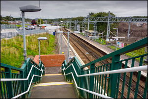
a while I was on a road then left it to follow a footbridge over the
railway at Cumbernauld Railway Station.
Cumbernauld
I followed a cycle track by
the road but for a short while I must have taken the wrong track as
I was on a narrow overgrown stretch of mud. Fortunately it ran
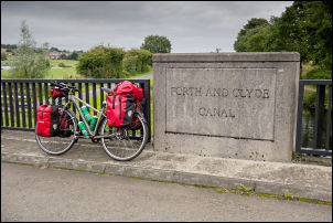
parallel to the road and eventually connected to it. At Abronhill
there was a right branch where I followed a narrow lane which
descended through Castle Cary and thankfully joined the Forth Clyde
Canal. Heading east I was riding along the towpath which had a
lovely flat tarmac surface. The overcast weather continue to
threaten rain but fortunately none came. There was even a tailwind
to help me on my way.
Forth and Clyde Canal
I came to a cyclist who had a wheel out of his
bike and was repairing a puncture. I stopped to check that he had
all the tools he needed, which he did. He'd had a puncture and was
replacing the inner tube. A couple of miles further on I reached Bonnybridge and left the canal to descend to the supermarket and buy
some water. It was fifty pence for a 2L bottle of which I bought
two. Across from the shop entrance I headed under a tunnel beneath
the canal. Although a cobbled road there is a cycle way adjacent and
I was able to wheel my bike through. There was a watercourse running
over the cobbled road and it was partly flooded.
Bonnybridge tunnel
I emerged at the
far side and joined a minor lane which headed east towards the line
of the Antonine Roman wall. At the end of the road I continued along
a rough track to the car park for the Roman wall and Rough Castle
access. The wall area is well tended and mown. I stopped briefly to
take some pictures but had to leave the wall as the cycle track
followed a rough unsurfaced track to the south.
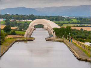
The Union Canal above the Falkirk Wheel
Camped on the Antonine Wall (earth bank)
I reach the railway
and crossed it by an underpass then further on crossed again to
continue on the rough track. I was heading in the general direction
of the Falkirk Wheel and had planned to camp somewhere around here.
I kept an eye open for a possible pitch site but couldn't see
anything suitable. I followed a track up to the side of the canal at
the northern tunnel portal. There was an area next to the canal
where my tent would have gone up but there were too many people on
the far bank. Wheeling my bike up a steep path I reached the top of
the tunnel entrance and a superb view out across the countryside.
Higher up I pushed my bike up a very steep path through the woods
and emerged on top of the northern Embankment of the Antonine Wall.
There was a minor path along it but it was quiet enough to pitch my
tent. It was an excellent pitch in the trees.