There was no wind during the night and
still none as I packed up. I was away just after 8am and the workmen
were already on the road setting up temporary traffic lights. I rode
back over the bridge to re-join the canal towpath. The lay-bye was
already full of cars for the new Lloyds bank building across the
main road. A traffic Warden had arrived on a small scooter and was
getting his recording device out but I couldn't see any parking
restrictions. Along the towpath there were patches of frost but
thankfully no ice.
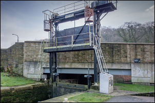
Guillotine Lock
Collapsing canal bridge at Elland
Passing the village
of Copley there were schoolchildren heading up the road to catch
their school bus. This is probably their last day before their
holidays. I reached the interesting area where the canal junction
becomes the Calder and Hebble Navigation. I branched off to follow
the lower level and stopped to photograph the guillotine lock. The
towpath took me through a tunnel and under the road. The canal
opened up into countryside with the road adjacent. Near Elland the
towpath was closed and I able to wheel my bike easily on to the
road. A road ‘closed ahead’ sign was there but I asked at a mobile
butty van what the situation was.
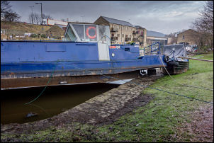
Stranded barge
I was told it was OK
for bikes so I wheeled my bike over the temporary footbridge to
cross the canal. I could see the road bridge had been severely
damages by the floods and the towpath under the bridge was
completely missing. The bridge was in a bad way with a lot of fallen
masonry and deep depression in the carriageway. The adjacent basin
had two barges which were high and dry on the wharf and it is
difficult to imagine how high the water must have been. I left the
canal for the last time and headed through Elland to the long steep
climb to the main road then a long descent into Huddersfield. It
seemed a complicated route through the town and I was glad to be out
on the other side. There was a long climb out on the A629. There
followed a succession of descents and very long climbs. Before
Penistone there was a lot of resurfacing work going on and traffic
lights. I left the main road to join the B6462 and steep descent
into Penistone. I stopped here for a £1.15 bag of chips for my
lunch. The descent in to the town now had to be paid for with a long
climb out and back to the A629. I left it at Chapeltown to head east
to Rotherham. In Rotherham I had to wheel my bike through a complex
junction to avoid a short length of one-way road. There was a
cyclist there who asked where I was heading. We had an interesting
chat then I left to head up a steep hill and on to Maltby. My
original plan was to camp here but it was only 2pm when I arrived so
decided to press on. I joined the A634 to join the A60 south into
Worksop.
Shepley
I stopped at
Morrisons to buy some water then followed the cycle route no6 to the
south. The barrier before the footbridge over the A57 was too narrow
for the bike and I had to take by rear bag off. I joined a narrow
quiet lane to the woods at Clumber Park and left the road to head
along the track through the woods. It was time to camp but I
couldn't find any ground that wasn’t a mass of brambles. I
eventually found a levelled a stoned area behind a barrier that was
the best I could find. It was far from satisfactory as getting the
pegs in far enough was a struggle. There were also hidden thorns
under the thin grass.