|
I'm heading off on my first back-packing trip of 2011 and breaking
with tradition. For my last trip in 2010 I used public transport but
it took such a long time to get to the start of the walk and back
I've decided to use my car for this trip. My starting point is
Coniston in Cumbria and with today being Sunday there is no
Ulverston Coniston bus. Normally I would get the train to Ulverston.
The morning drive was easy and very quiet. My planned walking route
was to start in Coniston and walk along the west shore of Coniston
Water to reach Torver. As my drive took me through Torver I stopped
briefly to leave my rucksack in the porch of St Luke's and pick it
up on my way through. |

Coniston Hall |
|
I then drove to Coniston and
Collingwood Close where I left my car as far out of the way as
possible. It was so easy and pleasant walking with no pack. It was
08:30am when I started walking and if I'd tried to get here by
public transport I'd probably not even have got to the railway
station by then. Through the village there were few people about and
even less traffic. I soon left the A593 road and followed the path
through the fields to Coniston Hall and its distinctive Chimney
Stacks. The hall was built by Squire William Fleming in the 16th
century. It also brought back pleasant memories of Scout Group and
family camping holidays back in the 1960s. The field where we camped
is now used for grazing.
The
public footpath passes Park Coppice and then heads for the lake
shore. An empty jetty and sign board indicates the summer pick up
point for the ferry. The path then headed through the trees but I
soon had to leave the shore and turn right across a small area of
open ground and along a rough farm track. It took me to Brackenbarrow Farm and continued unsurfaced to a minor road on the
outskirts of Torver. I crossed over then back in to the field along
another path down to the line of the old Coniston railway which is
marked with a shallow cutting at this point. Up the other side I
crossed the field and rejoined the main road. To the left was the
Old School Room next to St Luke's where I'd left my rucksack.
Earlier the main Church door was locked. This meant I wouldn't be
able to leave a donation so I put some money in the voluntary box
which is for the adjacent car park. |
|

Safety at Broughton Moor Quarry |
My pack was as I'd left it. Now I was
walking with a full load and certainly noticed the difference. I
followed the old road for a while then back to the main road before
turning up a steep narrow lane branching off to the right. The road
was very steeply up so I took my time. It was overcast and fairly
cold at just above freezing. A few icy patches remained at the road
side but didn't cause me any problems. After the steepest part of
the climb I came to the entrance to Broughton Moor Quarry of
Burlington Slate Ltd. |
|
A short way up their access road was a
locked gate which I climbed over. I followed the road upwards until
I entered the main quarry area and buildings. It is still a working
quarry but there were only a few vehicles about and being Sunday no
workers. At the top of the quarry I could see the fells of White
Pike and White Maiden ahead, though not the summits. |

Quarry buildings. |
|
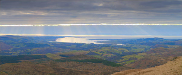
Estuary view. |
|

Yewry Sike Quarry |
I had to cross
a wire fence to get access to the open fell then headed up past a
shallow tarn and a higher small quarry called Yewry Sike Quarry
before climbing steeply up by the wall and parallel stream. The
stream was to be my water supply so I had to keep a close eye on it
so I didn't pass its source. When I judged it had just about gone I
left my pack and descended with my water bag to fill it before
returning. |
|
I continued up following the wall which then turned right
and ran straight up to the summit cairn of White Maiden at just over
600m. This was my camp for the night. The pitch was grassy and flat
but I had a job getting the pegs in due to the ground still being
frozen. |

Camp on White Maiden |
|
|
|
|