Return to Whittle Wanderer

Seatoller, Great Gable, Bow Fell, Wetherlam, Coniston, Cumbria. (4 day backpack)

Fri 21 May 2010

Fri 21 May 2010

Sat 22 May 2010

Sun 23 May 2010

Mon 24 May 2010

I caught the bus to Chorley and the fare had gone up to £1:80. The three trains I had to catch to get me to Windermere were all on time but the 11:08am bus to take me to Keswick was 10mins late. This concerned me because the connection time for my next bus was only 4mins. It turns out the 11:08 is frequently late because it is the first bus out of Lancaster after 09:30, the free pass watershed. So almost every stop has someone wanting to get on. I’d resigned myself to a missed bus and long wait in Keswick for the next one. It was warm and sunny as we trundled through the crowded Ambleside and Grasmere. There must be some leeway built in to the timetable because we reached Keswick on time and I was able to catch the 12:25 no78 bus to Seatoller.


The bus leaves Keswick


Passing through Seathwaite


The same location in the early 1950s

By now it had warmed up even more in the sunshine so I sat on the top deck which is open this time of year. Considering the nice weather there were few people on the bus and when we reached Seatoller I was the only passenger. Once off I readjusted my pack and set off walking at 1pm. A short way back along the road I took the branch lane to Seathwaite and was amazed how many cars were parked along the road side. I walked between the farm buildings and up the stony track to Stockley Bridge. I stopped for a drink of water and to take a photo before continuing up the climb to Styhead Gill. I took it steady and near the top a young man overtook me as he charged up the valley. Many were descending as it was now mid afternoon. It was pleasantly warm with a slight breeze. I reached Styhead Pass and turned right to head up the path to Great Gable. I’d previously made a note of the only water supply on Great Gable and soon reached the spring at 545m. I filled my water bag and tied it to the top of my pack. I would now have to carry it over 270m up the mountain so I made sure I kept a slow and steady pace.


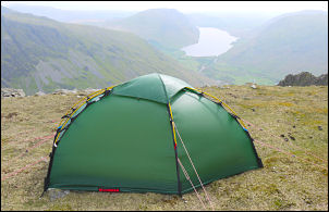
Camp on Great Gable with
Wast Water in the background.

Thankfully the path is well made and technically very easy. It was just a case of plodding steadily on. As with the lower path there were quite a few people heading down. I’d previously noted a possible camp on a flat grassy area at 804m but had also seen a possible area on Google Earth a little higher. Considering how high I was the mobile phone signal was very patchy. I moved to the Google spot at 814m and found not only a flat grassy patch with a mobile signal but a panoramic view of Sca Fell Pike, Sca Fell & Wast Water below. It was 4pm when I arrived and enjoyed pitching my new Hilleberg Soulo tent for the first time. The tent is designed to withstand severe weather but I doubt I’ll find a more calm and pleasant pitch as this for a long time.