|
Caught the 6:38am bus to Chorley
costing £1.80 single. Then the 7:01 train to Manchester Victoria. I
had about half an hour to wait for the Huddersfield train to Marsden
so had a wander about to find a waiting room. I asked one of the
ticket inspectors who told me there isn’t one and I’d have to sit on
one of the benches near the main entrance. The temperature was only
just above freezing and I don’t think that’s a civilised way for
people to wait for a train. At least the Gents toilets were free.
Not like 30p a pee at Waterloo Station last Saturday. The train left
on time and I reached Marsden Railway station at 9am. A few got on
but I was the only one to get off. |
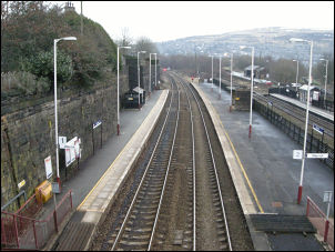
Marsden Railway station |
|
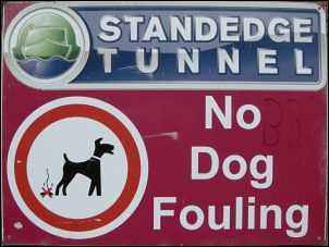
Pity many dog owners are illiterate |
It was overcast but
reasonably bright. I followed the steps up from the platform then
over the road bridge to join the Huddersfield Narrow Canal. There
was a very deep and narrow lock but the canal towards the tunnel
seemed the normal width. I followed the towpath and as I approached
the Standedge tunnel entrance the canal still had ice on it and one
stretch someone had written their names Dave and Jay by walking on
the ice and making the letters out of snow. The ice wouldn’t be
strong enough now but the letters remain. I passed under the railway
which also headed under the fells by another tunnel. The visitor
centre and canal basin was ahead but nobody was about. |
|

Huddersfield canal and warehouse |
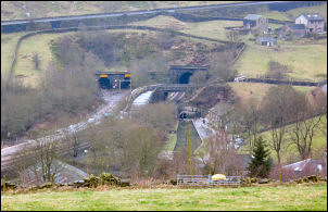
The 3 railway & canal tunnel |
|
I left the tunnel
portal up a lane to the Tunnel End Inn. A path headed steeply up the
side, through someone’s garden and along a rough lane to High Fall
Farm. I now had good views, if a little hazy, across to Marsden and
a large and probably disused mill. Just after Huck Hill Farm I
turned left up Huck Hill Lane which is just a rough track and as I
reached the double walled section I had difficulty getting through
because of deep snow that had drifted between the walls. It was much
easier to leave the track and walk in the field. At the top of the
track I reached open moor and a much improved path as it had been
paved with large stone slabs. They didn’t last too long but the path
remained quit good. In the distance I could see vehicles on the main
A640 road. I came to the still frozen Cupwith Reservoir and shortly
after crossing its impounding dam reached the road. I crossed over
then set off down a track towards Waterman’s House but soon reached
another walled lane that was filled with impenetrable snow. |

Descending Hey Lane |
|
I turned round and
returned to the main road to follow it NE to the wonderfully named
O’Cot then down O’Cot Lane. Turning right the lane dipped down by
Spring Royd then steeply up again. A descent took me down to go
under the M62 and continued down the narrow Hey Lane to a collection
of new and refurbished houses. It looked like a small community that
once existed around a mill. I left the road and crossed the river
using the wooden footbridge. A faint path headed up the valley side
then seemed to vanish when I reached the hedge at the top. The map
showed the path continuing along the hedge side but there was no
sign of it. Further on the way was obstructed by barbed wire but I
managed to climb over and find an old track on the far side. |
|

Old Mill Chimney at Penny Hill |
The views began to open up and
below was an impressive looking old mill chimney, The map showed a
path descending through the fields to the mill site but again access
was prevented with barbed wire,. I kept to the road and followed it
to Steel lane End where I took the steep muddy path down to the next
lane. I turned left and climbed steeply up and joined the next road
which I followed to North Royd. I paused briefly at the war memorial
then continued north through the village, past the school and on to
Butterworth End Lane. shortly after the caravan park on the right I
left the road and followed a path on to Norland Moor towards the
trig point. Last week I drove here to leave a water depot of two old
plastic milk containers filled with water. There is no good water
hereabouts so the depot was necessary. I found the containers hidden
in the heather and continued along the path following the edge of
the moor. I found a place to camp by an old quarry but the deep
heather made pitching a bit tricky. |