|
I was expecting the
wind to get up during the night but it wasn't too bad. Light rain
fell and the cloud rolled in making for a dismal start. I delayed
until after 9 before setting off but there was no improvement. I
headed for the trig point then took the minor path to the North
West. This is another case of the Ordnance Survey shooting
themselves in the foot by obliterating important detail by covering
it with a pointless wide green marker for the park boundary. Who
cares? It’s a meaningless line that serves no purpose to the walker.
I had to navigate by compass and the terrain was not the easiest to
navigate over. I came to Bush Howe and started a steep wet descent
to a saddle which I remembered from a previous walk some years ago.
A path crossed at right angles but I knew I had to go straight on
and steeply up to Breaks Head. I needed to leave the ridge and
descend to Blackethwaite Bottom but I wasn't sure where. A cairn
loomed out of the mist indicating that I'd gone to far. I set off on
a compass bearing towards my objective and headed down. |
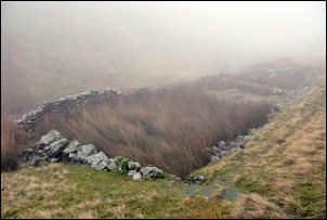
Great Ulgill Beck sheepfold. |
|
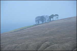
Above Tebaygill Beck, about all I saw
today. |
I was descending
diagonally which made it difficult and eventually came to a deep
ravine with a river in the bottom. It was Great Ulgill Beck and
after descending into it I came to the sheepfold shown on the map. A
faint trail took my down until I reached the misty Blakethwaite
Stone. This is another area where the fantastic work of the
surveyors has been obliterated by the morons who decide what width
and colour the boundary lines should be. The weather continued
miserable as I climbed slowly up to Uldale Head. The weather
forecast had said that it would brighten later but I couldn't see
any sign. I had some rough ground to cross to my planned camp and I
couldn't see a thing other than my compass. Crossing the featureless
terrain I crossed several bogs and finished up descending to
Tebaygill Beck in sqelchy boots. I reached my destination and found
the track on the map was nothing more than a drainage channel to
collect the water off the fell. A thoroughly wet misty and miserable
stage. |