Boyd's photo diary. |
|
|
|
|
|
|
Sun 29 Sep 2013
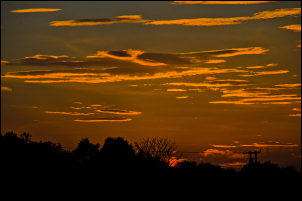
| A nice sunset sky
seen on my evening walk along the Leeds and Liverpool canal in
Whittle-le-Woods. |
 |
|
|
Sat 28 Sep 2013
|
Fri 27 Sep 2013
|

Sunny bike ride through Belmont. |
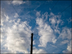
New telegraph pole outside our house |
| |
|
|
Wed 25 Sep 2013
| aa |
|
|
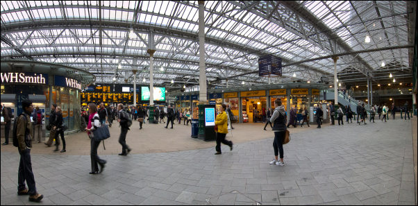
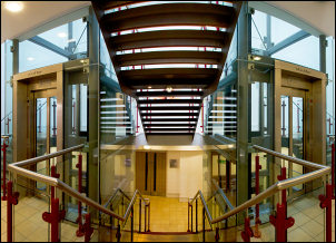
Homeward bound.
Waverley Railway Station, Edinburgh |
| |
|
|
Tue 24 Sep 2013
| I was hoping for
an interesting early morning view of Bamborough Castle.
Unfortunately it had been misty trough the night and was still
bad visibility in the morning. |
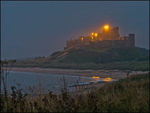
Bamburgh Castle on a misty morning. |
|
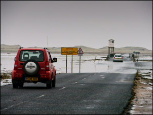
Falling tide at the Lindisfarne causeway to Holy Island |

Warning to those crossing on a rising tide |
|

Berwick upon Tweed old bridge and sundial. |

Holy Island causeway just before I cycled across. |
| |
|
|
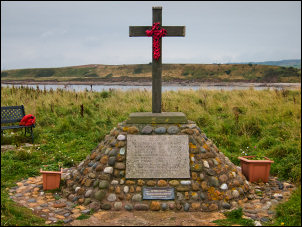
I camped at
Chapel Point by Skateraw Harbour. Across the harbour to the
south is Torness Nuclear Power Station. The memorial cross is to
the boys of St Giles - later Canongate-Boys Club, Edinburgh. It
was re-erected here in 1980 and dedicated by The Very Rev. Dr
Ronald Selby Wright C.V.O, The founder warden 1927-1978
In memory of
David Adams RAF aged 21
William Brown Lt BY aged 23
Jack Cooper RAOC aged 22
Jimmie Dalgleish MM RHA aged 23
Jim Stewart RAF aged 19
Jim Stobbie RN aged 19
Who loved to camp here and gave their lives that others too
might love it. |
 |
| The night photo
above is the memorial cross with the lights of the power station
behind |
 |
| |
|
|
|
Mon 23 Sep 2013
|
Sun 22 Sep 2013
| The first call of
the day was
Durham Cathedral |

Durham Cathedral |
|
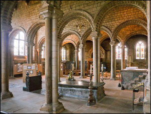
Inside the
cathedral I took out my camera and was told photography wasn't
allowed. When I asked why I was told it was intrusive. There was
hardly anyone around. I wandered away from the impressive nave
and found this quiet room with nobody about |
 |
|
I returned to
the nave and was again told not to take photos. After explaining
how I'd cycled a long way and how there were few people about I
was allowed to take this image. |
 |
|
After Durham I
visited Finchale Priory. The cafe was open and I was getting
hungry. They called this tray of chips a chip butty. It is a
tray of chips and a piece of bread at either end. |
 |
|
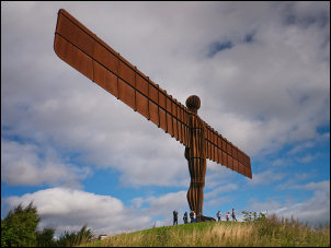
This is the first time I've visited the wonderful 'Angel
of the North' by Anthony Gormley. |

The adjacent information board revealed how deep the foundations
go. |
|

Wide view at Seaton Sluice |
| |
|
|
Sat 21 Sep 2013
| |
|
|
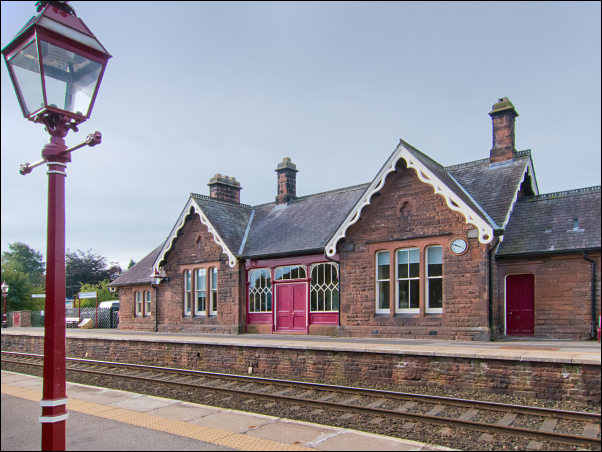
Lazonby Railway Station. Start of my cycle ride across England
and north to Scotland. |
| |
|
|
Wed 18 Sep 2013
|
 |
|
Seen outside a
house in
Nenthead, Cumbria. |
|
Sun 15 Sep 2013
|
The Open
Heritage Weekend events continued and today I joined a guided
tour of Rivington village in the pouring rain. One stop was at
the Rivington Unitarian Chapel. It dates from 1703. |
 |
|
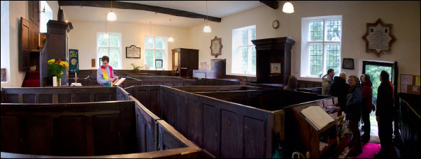
Rivington Unitarian Chapel interior showing the box-pews |
|
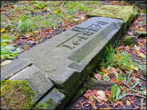
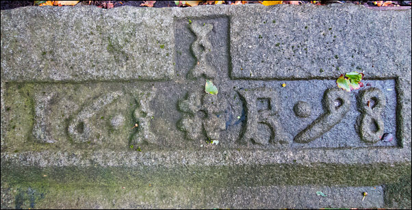
In the
graveyard area several stone door lintels recovered from various
properties that were demolished and submerged when the nearby
reservoirs were constructed in the mid 1800s. This one is:
I
16 I R 98
Which is
apparently to James and Rebecca Isherwood of Ainsworth’s (later
Wood’s) Farm. Though I'm puzzled by James being depicted by what
looks like an 'I'
The lintel pictures were taken on Tue 17 Sep 13 when I called in
on a bike ride.
|
 |
|
 |
|
Sat 14 Sep 2013
|
Part of the
week end's Open Heritage visits was to Chorley Unitarian Chapel. Doreen Jolly gave an excellent presentation
of historical memorabilia in the Unitarian Chapel on Park Street
Chorley. Along with the display Doreen described some of her
recent historical researches which each year add more
information to the wonderful history of the Church. |
 |
|
On this day in 1752 Great Britain
changed from the Julian calendar to the Gregorian calendar. This
meant that Wed 2nd Sep 1752 was followed by Thu 14th Sep 1752.
|
|
Fri 13 Sep 2013
|
During the
morning I walked over the 3 summits of Quinag in the mist. This
photo was taken on the descent just as I got below the clouds. |

Misty Quinag |
|
Ardvreck Castle
was built around 1590 by the Clan MacLeod family. Nearby is
Calda House, also near the shore of Loch Assynt. It was
built in 1726 but burnt down in mysterious circumstances in
1737. |
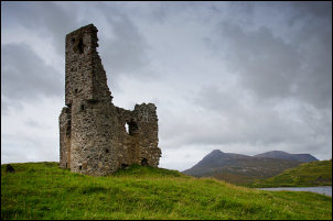
Ardvrek Castle & Quinag in the distance |
|
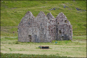
Calda House |

Calda House as it was in 1737. |
|
|
Thu 12 Sep 2013
|
Wed 11 Sep 2013
I'd just driven
444mile from home to the western point of Stoer. After the long
drive I enjoyed a short walk along the coast cliffs to Stoer
Point. The note on the wooden cabin says:
The Loo at the Light
This is probably the remotest public toilet on the mainland UK -
we hope you enjoy using it.
I couldn't enjoy it because it was
locked! |

The Loo at the Light |
|
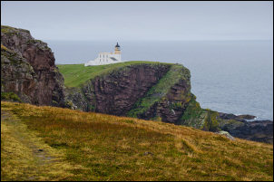
The Lighthouse from a windswept coast |
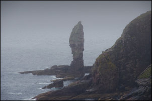
Misty view of the Old Man of Stoer |
| |
|
|
Sun 08 Sep 2013
 |
 |
|
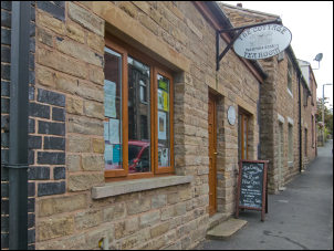
I was out for a
bike ride this morning and was delighted to see several bikes
parked along the fence by Railway Park in Brinscall. There were
no cyclists to be seen but a quick look through the window of
the cottage tearoom opposite solved the mystery. It reminded me
of my cycling club days in the mid 60s with the Ribble Valley
Cycle Club when we’d head off to distant villages and enjoy
large mugs of tea in local cafes. |
|
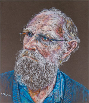
As I approached
home I called to see my good friend Jack. He is a keen local
historian and I had some information for him. I noticed a
wonderful portrait on his living room wall that a local artist
had painted. It was portrait of Jack painted for his 80th
birthday. It is a devastatingly accurate likeness. |
 |
|
Sat 07 Sep 2013
|
The ‘Road
Closed’ sign on Moor Road in incomplete and incorrect.
Considering they’ve closed it for 16 weeks from 27th Aug 2013
I’d have though more information would be useful. The sign
doesn’t say where the road is closed and doesn’t say it isn’t
closed to pedestrians and cyclists. |
 |
| |
|
|
Fri 06 Sep 2013
|
At the rear
(NW) side of Chorley St Laurence Parish Church is one of its old
entrances. It is also the bottom of Hollinshead Street and was
once the main road into Chorley. When the large house opposite
was converted to the ‘Swan with Two necks’ pub the area was made
into walls and tables. The pub closed over a year ago and the
area now resembles a rubbish dump. It is just a stones throw
away from the Town Hall. |
 |
| |
|
|
Wed 04 Sep 2013
|
While on a
cycle ride from White Coppice to Anglezarke I saw a sign saying
‘Road Closed ahead’ What annoys me is they don’t tell you where
the closure is. It wasn’t closed to pedestrians or cyclist but
they were too lazy to bother to tell anyone that. Being on a
bike I ignored the sign and found security barriers on the
Anglezarke Reservoir dam where a machine was digging the
embankment. |
 |
| |
|
|
Tue 03 Sep 2013
|
On the old road
from Nenthead to Mid Ashgill is this Telephone Call Box. There
is no phone inside and no mobile phone signal. What’s that all
about? |
 |
| |
|
|
Sun 01 Sep 2013
|
At 1pm I
arrived at Withnell Fold Sports and Social Club by the Cricket
Field for their monthly walk.
15 walkers headed though Withnell Fold village and down to the
canal bank where we turned right and headed towards Hoghton. Our
first brief stop was on the canal bank adjacent to the detached
house of Silverwood. To locals of Withnell Fold it has always
been known as the Gasworks as that is what it was build as by
Withnell Council around 1907 to provide gas to the area. It
ceased to be used as a gasworks many decades ago, probably in
the 1940s and from then on was a private dwelling. The old brick
retorts were removed in the 1960s and the house has been
considerable improved since then. Remnants of the coal loading
wharf is still visible along the towpath as some iron mooring
rings can still be seen.
In less than a mile the walkers crossed the bridge over the
canal and headed up the ancient grass track-way known as
‘Whave’s Lane’.
Its history goes back many centuries and it predates the Leeds
and Liverpool canal below which was opened in 1816. The Hoghton
Manor Court Records make reference to it on 22 April 1675 and it
states:
“It is ordered by this Jury the inhabitants of Olurton shall
well & suffiently scoure all & everie or theare pportionable
parts of the wheave [whave] lying betwixt Widow Livesey &
Olurton Wheave before the 24 day of June next in payne of VJs
VIIJd [six shillings and sixpence].
Meaning clean out the track side ditches or be fine. The
spelling is as the original and bear in mind the first main
English Dictionary would not be published for almost another
hundred years. |
|
Through
Ollerton the path crosses a lovely mown garden and over a small
hill with excellent views all around. We reached the main road,
crossed to Bury Lane then across a field path to the old
Parsonage building. Over the fence it was just possible to see
some old stones poking though the grass. They are all that
remains of Hoghton Old School. |

The long demolished Hoghton Old School is shown on the right |
|

The 1840s map showing the school. The blue line is the route we
walked |
|
We continued
along a grassy path though fields, passing the Golf Club on the
way. The path eventually descends towards the line of the old
disused railway and along Pleasant View. Up Norcross Brow we
joined the path that heads up on to the moors. The first part is
an access track to Withnell Villa which was the scene of a
gruesome murder on 5 March 1992.
The house was occupied by David Wilson who was visited by two
professional hit men who shot and killed him in the garage as
what appeared to be a smuggling related vendetta. |

Withnell Villa |
|
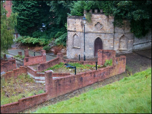
Leaving the
buildings behind we headed up on to the moors and across to the
main objective of the day, the ruin of Solomon’s Temple. It is
just a ruined farmhouse though the name would suggest otherwise.
The area was also one of the World War Two decoy sites known as
Starfish sites. Its purpose was to divert German Bombers by
igniting fires and showing patterned lights on the moors. The
theory being that bombers would see the fires at night and
assume it was a burning factory previously hit then aim at the
site so saving the real target. |
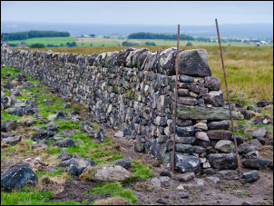
Wall re-building near Solomon's Temple |
|
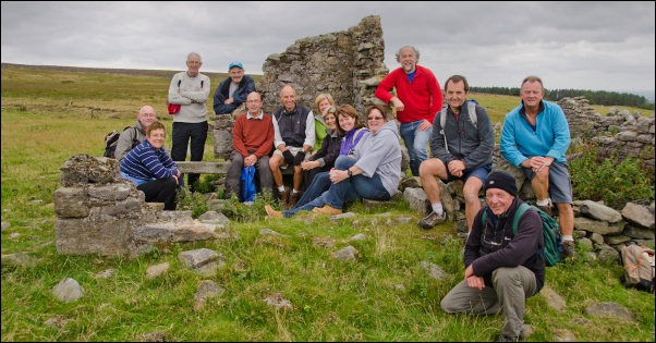
The group at Solomon's Temple |
|
There are no
remains of the oil tanks but some lighting pole bases can still
be seen and the underground wires can be located with a metal
detector. Further down Hatch Brook was the brick and earthenware
oil trap that was originally built to prevent oil from the tanks
running down the brook. |

The oil trap in Hatch Brook |
|

Warning on Harbour Lane |
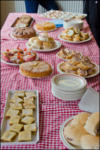
Thanks to Audrey for the fantastic spread of food |
|
Down through
the Brinscall Pine Woods we passed Brinscall Hall, up through
fields to Harbour Lane and across the fields to Higher Wheelton
and back to the Sports Club for tea and cakes.
It was an enjoyable walk of 12.9km (8 miles) |
|

Plan of the walk |
|
|
|