|
|
Lat/Long: 56.801050, -04.039079
OS
Grid ref: NN 75493 69563
|
|
|
|
|
|
An easy morning drive to Scotland.Called at Perth on the way to
get diesel and managed over 71 mpg. Then drove on to Dalnamein
where I parked by what looks like a council depot for stone etc.
I set off north, crossing the busy A9 to head for the pine
forest. First I made a short detour to the right to check if the
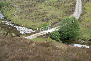
old military road bridge was still there, it was. |

Military bridge. |

No gold panning. |
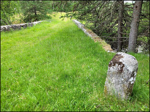
Bridge & milepost.
|
|
Over the bridge was the old milepost but no visible markings. A
sign was on a board warning against panning for gold! I followed
the track up through the trees and out on to the entrance to the
glen I could see the ruins of Ruighe Chail up ahead as I started
to descend to the bridge over the river. A short way downstream
was a much older bridge with only the bridge abutments remaining
and a couple of old poles across. |
Bridge. |

Ruighe Chail. |

Above Ruighe Chail
|

Ruighe Chail.
|
|
On the other side I climbed up to inspect the ruins which were
fairly intact except for the roof having collapsed long ago. The
largest building was the northernmost and the south gable was
still full height to the chimney. The outer wall had been
rendered and it looked like bullet holes all over it. |
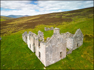
Ruighe Chail. |
|
I returned by the same track back to my car but decided to check
on a footbridge across the River Garry that is shown on my OS
map. I walked east along the old A9 then down a field to where
the bridge had been. A sign said it was out of use and the
bridge had long since been swept away. I returned to the car and
saw a couple drive down a track towards a building on the far
side of the River Garry. The map doesn’t show a bridge but a
ford. They got to the river and it looks like they weren’t going
to risk taking their car through so were about to wade across. I
left and drove north to Dalnaspidal. |
|
|
|