|
Thirlmere, The Swirls, Birk Side, Helvellyn,
Brownrigg Well, Lower Man, Cumbria |
|
|
Lat/Long: 54.546542, -03.058643 OS Grid ref: NY 31616 17325 There was heavy rain and mist on my drive north along the M6. I left at Penrith to head west and hopefully drive to Thirlmere for the start of my walk. The B5322 through St Johns in the Vale was signposted as closed so I had to continue to Keswick and then come back along the A591 to the section of old road just north of the Swirls car park. |
 Memorial bench above Thirlemere |
| The car park is pay for and hideously expensive so this short length of road is ideal for parking. There were already two cars there when I arrived. I walked south along the road the short distance to the car park. I was heading along the forestry track high above Thirlmere and running approximately parallel to the main road. The normal route is a right fork at the car park but another track goes to the left of The Swirls. The Ordnance Survey map doesn't show the track joining the main one but an on-line map at osm shows it connecting. |
 Mellbreak |
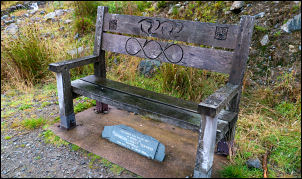
| I decided to try the track and see if it did. It was a pleasant walk up through the forest and the higher I got the rougher the track became. It ended as I expected and there was a stile over the fence and a faint path continuing through the woods. As I continued the path reached a fence and petered out. I had no choice but to follow it and make the best route I could to the main track. It was quite steep down for a while and I climbed another fence and through some moss covered boulders to descend through the trees. There was no sign of a path but eventually I met the main track. It was a pleasant walk south and I soon reached my first objective which was the memorial bench by the river below the old mine workings. The bench commemorates two young male cyclists who were killed by a coach driver in 2010 though this isn't mentioned on the plaque. “In memory of Christian and Niggy Townend aged 29 & 21 who died 5th Dec 2010” | |
 Christian & Niggy Townend |
|
| I continued south and left the track to turn left up the main path from the Whitburn car park. This is the main ascent up Helvellyn from tis side and I have walked it many times before. It is steady and easy with a good path under foot. It winds steeply up to Combe Crags where there is the remains of an old stone Shepherds Hut. I stopped here for my sandwiches and hoped the weather may clear a bit but it didn't. |
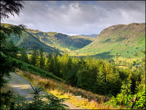 View near the memorial bench |
| It was still misty and as I climbed upwards light rain began to fall. I had to put full waterproofs on as it was raining quite hard. I was in thick mist as I reached Nethermost Pike and instead of heading directly for the Helvellyn shelter stones I took the right branch to follow the minor path towards Striding Edge. It is a very steep drop-off but there was nothing to see. I reach the path coming up from Striding Edge where there is a memorial on the hillside that I wanted to photograph. It is to Charles Gough Memorial who died on the mountain in 1805. There was a man and young lady sat there so I asked them to move for a few seconds while I took a photo. This they happily did and we began chatting about our walks. |
 Charles Gough Memorial. |
| The man was originally from Preston but emigrated to Australia 30 years ago and the young lady was his daughter. He had returned to England for a few weeks walking before returning home to Australia in a week's time. The weather cleared a little and I managed to get a brief view of Striding Edge and Red Tarn below. |
 Red Tarn & Striding Edge |
 Helvellyn summit trig post |
|
| However the clouds rolled in as I walked past the Helvellyn shelter stones and then on to the trig post. I stopped briefly then left the path to descend to the west to have a look at Brownrigg Well. This is the highest spring in England and I have wild-camped here a few times in the past. It was still very cloudy but I had reasonable views to the west. |
 Brownrigg well |
| As I started my descent on the main northwest descent path by Lower Man there were many walkers coming up from the Swirls end. The path is in good condition and The descent down the ridge is well stepped and fairly easy to negotiate. There was a constant stream of tourists heading up and it was nice to see the majority acknowledged my greeting. I briefly had nice views to the north and Blencathra. | |
 Blencathra in the distance |
|
 Ruin on the descent |
 New underpass |
| When I reached the car park I followed another footpath which went under the A591 by a new underpass to gain access to the car park on the west side. This is a new construction and must have been built when the A591 was closed for the rebuilding works at the river collapse at the south end of Thirlemere in the Dec 2015 floods. | |