|
Haweswater, Blea Water, Riggindale, Cumbria. |
|
|
Lat/Long: 54.489146, -02.820441 OS Grid ref: NY 46950 10733 A dark and very windy Drive North along the M6 where I left at Shap and followed the narrow lanes to Haweswater. It was raining and had continued to rain through the night so there were many sections partially flooded. It was just coming light as I reached the car park at the south end of Haweswater. I was the only vehicle there. The rain intensity had varied and shortly before I set off walking it almost stopped. As I set off it started again accompanied by strong winds. |
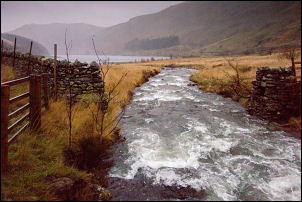 Haweswater inlet |
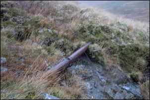 Outlet pipe from Blea Water |
 Blea Water overflow weir |
| My first objective was Blea Water and the track was partly flooded for most of the way. As I climbed up adjacent to the Beck there was a lot of water coming straight off the hill and flowing across the path. I was heading for the outlet damn at Blea Water but on the way noticed an old track running along a steep slope towards some old Quarry workings below Piot Crag. I must try and return in the future to investigate. The rain wasn't too bad and the wind had't increased much in force as I reached the dam. |
 Blea Water outlet valve chamber |
| Unfortunately things soon changed and the wind began to increase in fury and the rain became much heavier. I stood by the Dam overflow and watched the water level fluctuates causing the river below to almost dry up and then be in flood. The cycle seemed to run about every 90 seconds. Presumably this is the effect of the high winds on the surface of the water. I could see across the tarn to the far side but the fells above were in thick cloud. |
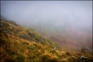 Looking down into Riggindale |
| Yesterday I’d installed the Peak Finder app on my phone and tried to use it but the rain and wind along with the cloud made it impossible to give it a proper trial. I started my climb up to Caspel Gate heading northwest steeply up the fellside. There is a reasonable path but it became more difficult as the wind increased in force. I reached Riggindale Crag where I stopped to decide what to do next. My original plan was to continue up to High Street but the winds would have been too dangerous up there so I reverted to Plan B to return via Riggindale. I hadn't been going long when I realised my decision was the correct one as it was impossible to stand at times and I had to crouch down to let the high winds subside. | |
 Haweswater |
|
| It became more difficult to make headway but fortunately I came to a fairly new post and wire fence running the same direction as I was heading. I was able to keep hold of it to remain upright but occasionally the wind coming from the south would blow me up against the fence pinning me there so I was unable to move until the wind subsided. When the fence turned off to the right I continued following the old wall and moved to the north side to try and get some shelter. Descending Heron Crag and Swine Crag was a bit tricky due to the wet steep ground with rocks underneath. I was thankful to reach the reservoir level near The Rigg and then turned to head southwest along the path which was now a running river. I got back to my car and retrieved some dry clothes from the boot and sat on the back seat to strip off my wet clothes and put on some dry. It was still extremely windy as I drove away but the rain had subsided considerably. | |