|
Crummock, Rannerdale, Whiteless Pike, Wandope,
Grasmoor, Hopegill Head, Whiteside, Cumbria |
|
|
OS
Grid ref: NY 15898 20788 Lat/Long: 54.575284, -03.302543 The weather forecast said this was to be the best day of the week but all I saw as I drove through Cumbria was low cloud. I reached the car park near Crummock Water and I was the first there. Just before I set off a campervan turned up. On the side of the vehicle was: http://www.bitadventures.co.uk/ |
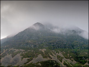 Gloomy view of Grasmoor at start of walk |
| I followed the road south under a gloomy sky to the next car park where I left the road to follow a path towards Rannerdale. Squat Beck runs down the valley and the first sign I saw asked visitors not to trample on the bluebells. I was puzzled by the spelling on the sign as it called Rannerdale ‘Rannadale’.The weather continued gloomy and up ahead was low cloud. |
 Walking south by Crummock Water |
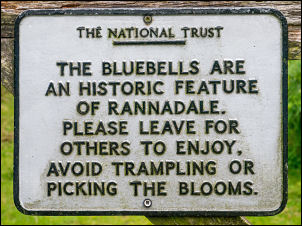 Rannadale & bluebells |
 Eastbow Hill summit trig post looking north |
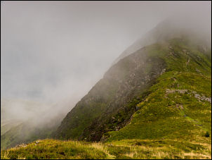
| Even so the valley looked extremely attractive. At the head of the valley I turned left to head steeply up Whiteless Breast and up into the cloud. I wouldn’t descend out of it until the end of my walk. The higher part was steep and rocky and without warning I was on the summit of Whiteless Pike and standing by the low pile of small stones that represent a pathetic cairn. |
 Crummock Water & Loweswater in the distance |
| I continued along Whiteless Edge which must have impressive views but I couldn’t see anything through the mist. My next objective was Wandope Moss summit which had a reasonable cairn. A sharp turn left and I descended slightly before starting the climb to Grasmoor. After a short climb I reached the summit area which is a large plateau. |
 Looking down to Sail Beck |
| I reached the shelter stones then turned round to start my descent towards Coledale Hause. There were partial views of the impressive descents into Gasgale Gill. It was here that I saw the first people of the day. Two walkers were coming up my descent route. At Coledale Hause I climbed up to Sand Hill and Hopegill head. |
 Grasmoor shelter stones in the mist |
| It was still cloudy and I was frustrated not being able to see what must have been impressive views. I turned left to head west along the impressive Whiteside Ridge. It wasn’t until I reached the much lower Whin Ben that I descended below the cloud and could see Crummock Water below. |
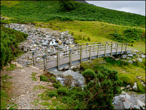 Footbridge at Liza Beck |
|
As I crossed the flat ground back to the car
park I watched a helicopter fly south and land in a field by the
Lanthwaite property across the road. It looked like it was transporting
passengers. A search on G-NIVA showed Lanthwaite Aviation operating the
EC155 G-NIVA, a corporate helicopter operating in the UK and available for
charter & business transport. |
 EC155 G-NIVA |
|
|
|