|
A calm night but very misty by
morning. The daytime temperatures yesterday were in the 20s but had
dropped to 9degC overnight. Last night was the first time I’d used
my new Higear sleeping mat. I found it excellent and better than the
thermarest mat that de-laminated on my trip last month. The Higear
is less than one third of the price at £25. Packing away was very
uncomfortable because of the clouds of midges and I needed to put a
bag with eyeholes over my head when outside. |
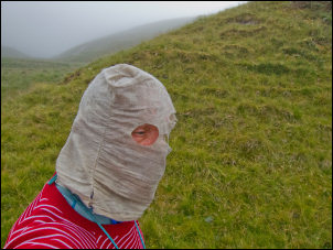
Midge repellent |
|
The anti-insect spray
I’d brought didn’t make a scrap of difference. My original plan was
to descend the mountain road directly to Rhayader but a closer look
at the map revealed that a series of reservoirs to the south would
be a more scenic route. I took the branch right on the descent and
could just make out the highest of the reservoirs through the mist.
Although the road was generally close to the top water level it had
quite a few undulations. I noticed a group of back-packers heading
up the hillside and vanishing into the cloud. |
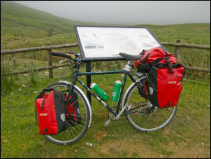
Bike and information board |
|
Don't cycle through picnics |
Don't pick the flowers |
|
The few farmers I saw
driving their land rovers and trailers would pass without a wave of
recognition which is what I usually get as a solo cyclist. The first
reservoir was Craig Goch and I stopped at the dam to have a look.
Craig Goch Dam is topmost of a series of dams in the Elan Valley,
built by the City of Birmingham from 1893 to 1904 to supply
Birmingham with drinking water. The scheme involved the construction
of 4 dams, an aqueduct 126 km long, and a village for construction
workers. The height of the reservoirs enabled water to reach the
outskirts of Birmingham by gravity alone, without the expense of
pumping. Across the valley was a track which appears to be a cycle
track. |
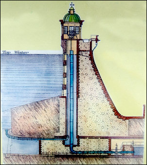
Craig Goch dam |
|

Craig Goch dam |
|
There were back packers on that too. Pen Y Garreg followed
then Garreg Ddu (Caban Goch) which seemed to have a turbine house.
The road continued fairy flat and I followed it to Rhayeder. The
town didn’t seem particularly interesting so I didn’t stop but
continued up a very long straight climb nthen descent towards St
Harmon. I descended into St Harmon and saw a ‘open - teas’ sign
outside St Garmon's Church or St Harmon Church. It was rebuilt in
1821 on an earlier site. I rode through the gate and up to the
church porch. |
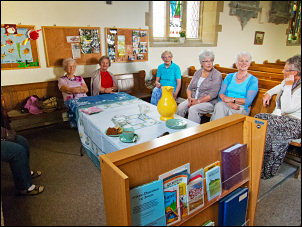
Lovely ladies of St Harmon |
|
A lady was there and invited me it. It
looked like a ladies coffee morning so I sat down with them and
£1.50 (I gave £2) got me a cup of tea and as much cake as I wanted.
It was a very nice stop with food and conversation. Perhaps the
farmers of Wales could take some tips from the ladies. I followed
narrow lanes to the A483 which I only joined for a short way before
turning left to an even smaller road heading steeply up thought
trees. It was so steep I had to push the bike. |
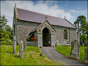
St Garmon's Church |
|
The lane continued very narrow with
grass growing along the middle. As I got higher I was able to see
the surrounding hills which weren’t as high as I’d passed through.
The morning mist had cleared and the high cloud began to clear as
well allowing the day to warm up considerably. I came to a farm
where the road degenerated to a dusty track and seemed to end at a
gate. At first I though I may have taken a wrong turn but a rough
tarmac track on the other side of the gate indicated I hadn’t.
Through the gate I pushed my bike up a very steep hill and a sheep
droppings covered road to another gate where things improved
considerably. |

Rough road |
|
The road ran flat
across a wonderful area of grassy plateau before descending to a
larger road. It was now getting warmer and the temperature was over
30degC and patches of tarmac on the road were melting. It was
strange that apart from one land rover I hadn’t seen a car for over
an hour. I came to the line of the railway and generally followed
its line to Knucklas where I stopped to look at the spectacular
13-arch span railway viaduct completed by the Central Wales Railway
in 1865 which passes over the valley. One end was castellated and
looked very impressive. |

Knucklas viaduct |
|
I soon came to the B4355 and followed it to Knighton. This is where Offa’s Dyke crosses the road and there was
an information building at the location. I didn’t investigate but
continued through the town to the Spar shop to buy a 5lt container
of water. While riding the temperature was 32degC but when I stopped
to go into the shop it rose to 34. I left the town by the Railway
station and soon left the road for a minor road which ran parallel
to the railway line. The road was in a very bad condition, full of
deep ruts and covered in loose gravel. I was glad to emerge at
Bucknell where I continued along the B4367. The heat had melted
large areas of the road surface making for some interesting tyre
noises as I rode. It was now time to find somewhere to camp for the
night as I’d almost done 50miles. |

Coxall Baptist Church |
|
Farm vehicles were preparing to leave
a field to the left so I though I’d ask if it was OK to camp in the
field. As I approached both vehicles drove on to the road and away
so I didn’t get chance to ask. A short way further on was the
isolated Coxall Baptist Church which dates from around 1861. The
main graveyard was at the front but behind the brick church was a
grassy area with a few graves but a larger mown area that was clear.
I decided to stop here. |