|
The wind slackened but the rain
hammered down all night. The temperature was just below freezing but
at daylight at rose a bit. I packed the tent away in very wet snow
and I tried to keep my feet dry as cycling shoes are not very
waterproof. I set off east along the A6. The worst of last night’s
snow on the road had gone but as I cycled in to Taddington the minor
roads were still deep in snow and too dangerous to cycle on. I took
a minor track to rejoin the A6. |
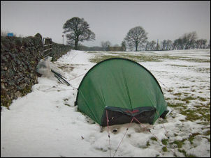
Any port in a storm.
A soggy field by the A6 |
|
I’d put on full waterproofs to keep
the cold wind out but the rain got harder so I’m glad I was
prepared. For a while I had a long descent then the road levelled
off on the approach to Bakewell. I stopped in Bakewell for a snack
and take a couple of photos. The sun came out very briefly but by
the time I’d got my camera out it had gone. I left the A6 and set
off on the A619 to Baslow. After the roundabout I took the
Chesterfield road and started a very long climb. The thawing snow
was causing huge amounts of water to cascade off the fields and
across the road. As I got higher the rain started again and I rode
the last few miles into Chesterfield with my rain top on. |

Chesterfield and the crooked spire |
|
In Chesterfield the sun came out for a
while so I had a look at the Parish Church and its twisted spire. I
also popped inside for a quick look. My next objective was Staveley
and navigating out of Chesterfield wasn’t easy as the Staveley
signposts were for cars and not cyclist. I managed to find the way
but the urban area around Staveley was as built up as the town. |
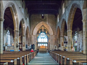
Chesterfield Parish Church interior |
|
I didn’t even notice I’d ridden
through it as it didn’t seem to have any redeeming features to
identify it. I headed NE and over the M1 motorway to Barlborough.
This was another place with no obvious centre. The A619 east was a
nice flat road with sweeping curves but too busy to enjoy. I turned
north on the A618 for a while then along a minor road to Harthill. |
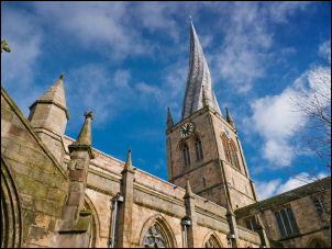
Chesterfield Parish Church
and its crooked spire.
It is thought the twisting of the 14th century spire
is due to insufficient cross-bracing,
and the use of unseasoned timber. |
|
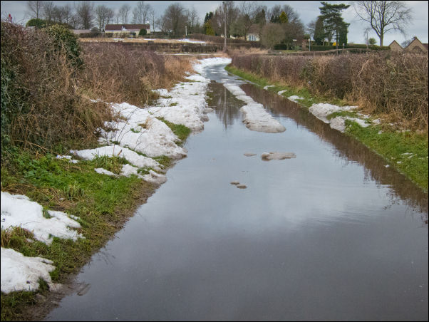
Flooded lane near Harthill |
|
I took a minor road
and was concerned to find a lot of snow on it and some flooded
sections where the snow had melted. Fortunately they weren’t too
deep. I reached Kiveton Park railway crossing and station. It even
had the signal box there but is probably not used. A steep climb
took me to South Anston and on to North Anston and Dinnington. I
called at the Tesco Supermarket in Dinnington to buy some water.
Still water was 17p per 2lt bottle which must be the cheapest I’ve
seen. I didn’t have far to go and it was still only 13:45. I’d found
what I thought was a good place to camp using Google Streetmaps
before I left. I followed the lanes to the spot and found what I
thought would be quiet county lanes were busy thoroughfares. I
pitched my tent and tried to listen to the radio while speeding
traffic whizzed by. |