Return to Whittle Wanderer

Tebay, Jeffrey's Mount, Whinash, Whinfell Common, Grayrigg Pike, Cumbria. (3 day backpack)
Fri 18 - Sun 20 Nov 2011

Fri 18 Nov 2011

Fri 18 Nov 2011

Sat 19 Nov 2011

Sun 20 Nov 2011

NY 6178 0464
The last time I was backpacking was Sep 2011. I was away most of Oct in Nepal so this is the first chance I've had to get away. I've walked over Jeffrey's Mount before and wondered if a camp on the summit would be feasible. The main problem being water as there isn't a decent supply near the summit. I decided to give it a go and drove to Tebay and left the car on Orton Rd. Instead of heading directly for the hills I decided to investigate some paths to the north that I'd not been on. I set off north and crossed the large roundabout at the A685. I continued north along the B6260, passing the sports ground on the right then over Tebay Bridge and the River Lune. To the left was a farm track to Bybeck which took me under the M6 motorway and on to a wooden bridge across Birk Beck.


Motte and Bailey


path by the river

I peered into the water and was amazed at how dirty it was. There didn't seem to have been any substantial rain for a while so I'm not sure what's caused the discolouration. Just to the east it joins the river Lune. Across the Lune I could see the interesting profile of Castle How which shows the shape of the classic Motte and Bailey defence system. The map shows a branch path crossing the River Lune and I wanted to see how it did it. The answer was it didn't. If you want to cross here be prepared for a very deep and dangerous wade. There is no footbridge. Why a stile goes over the fence to lead you to possible drowning and death in the river I have no idea. Looks like when health and safety is really needed it turns a blind eye. The path continued south by the river bank and under the motorway bridge where many sheep were taking shelter. Further along the river bank was a fairly rusty footbridge.

The map says FBs (footbridges) and Fords. There's only one bridge and certainly no ford. Next I passed under the railway then under the motorway again and along a farm track to the narrow lane on the outskirts of Roundthwaite. I reached the hamlet and sat on the wall by the bridge parapet for a while. I followed the crumbly and stony track to the SE above Roundthwaite Beck. I'm heading for a camp on Jeffrey's Mount and as I've been over it a couple of times before I know there's no water on the summit. I continued up the valley to a point where a stream runs down from higher ground. I followed it uphill and eventually stopped to fill my water bag before continuing uphill. It was steep for a while but didn't take long to reach more level ground. As I got higher the wind increased considerably and was very strong by the time I reached the summit area.


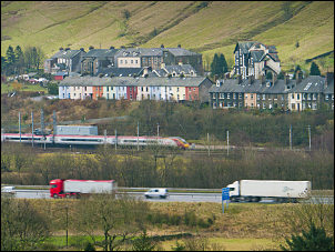
M6 motorway, the railway and Tebay behind

A small cairn of stones is all that marks what appears to be the summit. I could see the motorway far below as it snakes its way along the valley bottom by the River Lune. Even with the wind I could still hear the motorway noise in the distance. I found a spot to the west of the summit to pitch my tent. It was exposed to the wind but there was no shelter anywhere. With good ground to get the pegs well in I wasn't concerned about the wind. The only problem it caused was the incredible noise it made as the tent fabric got a battering. At least it drowned out any motorway noise.