|
There were some very rainy and windy
squalls during the night which kept waking me up. By morning the
wind had died down but I was surrounded by thick mist and drizzle. I
was on my way out today so had an early start. I was packed up and
away at 06:30 and headed up a very wet path to the summit of
Hallsfell. The only thing to see was the circular concrete trig
point set in the ground. I headed SW along the ridge path which on a
good day has one of the finest views in Cumbria. |
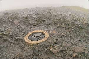
Hallsfell summit and circular trig point |
|

Distant view of St john's in the Vale through the rain |
Today there was nothing to see so I
pressed on to the edge of Blease Fell where the main path descends.
Just before the descent a sign was stuck in the ground. It was path
alteration notice which was to indicate the accurate position of
paths on the ground and change the fictitious path which is shown on
the map, path FP369021 which does not and never has existed. I’ve
written many times about the ludicrous routes of paths on the maps
which are not only wrong but dangerous. The notice reads:
We have confirmed orders which have changed the mapped path network
in this area. There are no changes to the paths that exist on the
ground – the orders have just changed the legal maps to accurately
show where they are. |
|
The steepest section has been well
engineered into a series of zig-zags but where the gradient eases
the paths split. I followed the direct route down towards the
Blencathra Centre then left to join the road lower down. I continued
down and through the village of Threlkeld to the main A66 road. My
plan was to follow the line of the old railway line back to Keswick
where I knew there was a footpath. However, I didn’t know where the
path started. The path soon turned right, leaving the road and
heading down through the trees. |

Old Railway Bridge over the River Greta |
|

From tunnel to bridge |
I then found myself of the railway
path crossing the River Greta by the old railway bridge. I couldn’t
really enjoy the walk as much as I’d like as the light rain of
earlier in the day had now reached torrential proportions. I walked
through the rain until I came to where the A66 crosses the railway
route. The railway route had to be obliterated for the road so the
path has been diverted along an impressive boardwalk which almost
hangs over the river. The rain was too heavy to take my camera out
for a photo. I had some shelter as I passed under the road bridge
but then was out in the rain until I reached the old Keswick Railway
Station. It’s now a hotel but I was able to walk on the platform to
get some shelter. I was soon back on Brundholme Road and back to the
car. It was a very welcome sight as I had shelter and dry stuff to
put on. |
|

Keswick Railway Station this morning |

Keswick Railway Station in busier times |
|
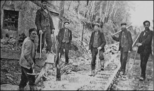
Railway Navvies who maintained
the track |

The last train in 1972 |
|
|