|
I looked out of the tent during the night to see if there was any
sign of the Perseid meteor shower. I could see a few stars through
the thin cloud cover but nothing else. The night was calm and so was
the morning. The new tent was quick and easy to pack up but my main
problem was the clouds of midges which were very annoying. I can't
think of a similar intensity since I camped in Scotland. I was
underway by 6:50am. I set off up towards Ickornshaw Moor on a path
constructed of large stone slabs like those on Spittlers Edge near
Winter Hill. I would see quite a few of these during the day and
they were probably brought in the same way the Winter Hill ones
were; by helicopter. I hadn't been going long before I noticed an
area of peat cutting, probably for use in the stoves of the huts I
passed yesterday. |

Sunrise over Cowling |
|
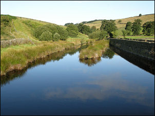
Ponden Reservoir |
The moor was featureless with little to see in the distance. The map
shows a strangely named area called 'The Sea'. Approaching it I saw
the trig point by Little Wolf Stones to confirm I was on the correct
path. At Old Bess Hill I came to a long straight wall descending all
the way to the road. I turned left at the road and followed it to
where the culvert parapet had recently been reconstructed and left
it to follow a path to a farm track steeply down then fields down to
the lower road by Ponden Reservoir. I took the path up a steep field
then track to the interesting looking Ponden Hall. |
|
Then it was down to the Reservoir again and then up a track to
Buckley Farm. Continuing the track turned right to Upper Heights
where the map shows a camp site. On reaching it I came to
refurbished farm building and a sign saying Campsite Closed. Another
of those fancy farm buildings owned by antisocial people with
'private' signs. |

Walkers not welcome |
|
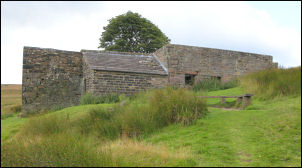
Top Withens |
Continuing up the moor I came to Top Withens which I visited the
other week on a day walk. It is reputed to be the fictional location
of Wuthering Heights in the Bronte novel. I didn't stop long as a
couple of noisy walkers were coming up behind. I pressed on over
Withins Heights Ends and started the descent to Walshaw Dean Middle
Reservoir. |
|
On the way I noticed a boulder by the path with a stone plaque
cemented on the top. In inscription had been cut reading 'F
Wilkinson A Rambler died Aug 31 1964 aged 35'. I followed the path
by the reservoir bank then another path by the lower reservoir until
I reached its embankment. It was now 11am so I decided to stop for
lunch. I made a brew and cooked some noodles while trying to fend
off the clouds of midges. As I sat there a few groups of walkers
passed the other way. By 12 noon I was on my way again. The route
now followed a decent vehicle track to the road. I soon left it to
take the track to Gorple Lower Reservoir. |

F Wilkinson A Rambler died Aug 31 1964
aged 35 |
|

Reservoir valve tower |
I saw a man by the river with a ‘total station theodolite’ and GPS
unit on a pole. I asked him what he was doing and he explained he
was contouring the river bed to asses the fish situation at various
river levels. Over the reservoir dam I headed up Reaps Coppy to a
higher path following the contour. I met a couple coming the other
way who wanted to know if the pub was open on the road below. They
were referring to the Pack Horse which I hadn't passed so was unable
to comment. It was still early but I was now looking for somewhere
to camp as further on I would be too near to civilisation. Above
Clough Head was a small stream of very dark water. At least it was
running, just, so decided to pitch here. |
|
|