Return to Whittle Wanderer

Stonethwaite, Langstrath, Allen Crags, Grey Knotts, Honister, Cumbria. (3 day backpack)

Tue 23 Sep 2008

Tue 23 Sep 2008
Wed 24 Sep 2008
Thu 25 Sep 2008


The 7:30am bus to Chorley arrived on time though the fare has recently gone up 10p to £1.70 for the one way journey. Then the 8:17 Glasgow train was on time but had insufficient seats and many had to stand all the way to Lancaster. I stayed on to Penrith where I caught the 9:30 bus to Keswick where I was horrified to see a huge crowd of ageing walkers taking advantage of the nice weather and waiting for the 10:25 no 79 bus to Seatoller. There were so many that I thought there was a real danger of not getting on the bus. Fortunately the Buttermere bus took quite a lot and when the bus arrived we all managed to fit. It was open topped so I sat upstairs to get much better views of Derwentwater as we drove towards Seatoller where the bus turns round to return. I got off at the Stonethwaite road end, one stop before.


Stonethwaite


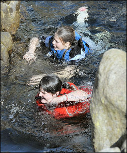
Swimming at Black Moss Pot.

It was 10:51am as I stepped off the bus in calm sunny weather. I found it surprising that with a bus full of walkers I was only one to get off here. I set off along the road and 
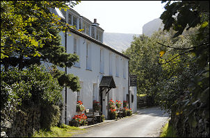
soon reached Stonethwaite village, though I’m not sure if it’s technically big enough for village status. The track to the campsite had just had some surface repairs done to it along with rolling, though it didn’t look like tarmac. After the campsite entrance the track deteriorates to very stony and difficult underfoot. I pressed on and was thankful that I wasn’t walking through the usual rain. I turned south into Langstrath and when I reached Blackmoss Pot I noticed a group of teenagers by the waterfall and pool. They were making the most of the fine weather by jumping in off the high surrounding rocks. They were properly equipped with life jackets and some had wet suits. I was now off the stony track and on a more level and easier path. The valley is now wide and flat for about a mile before I came to the footbridge at Tray Dub.

I stayed on the west side of Langstrath Beck. The map shows a sheepfold which I tried to find but missed. The ground is very lumpy and quite wet in places so I had many detours to keep my feet dry for as long as possible. Up to the right I could see the high valley leading to High House Tarn, my objective. The way up was very steep and rocky and I had to be extra careful. What looked like the top wasn’t. A distant high waterfall had water issuing from a hanging valley. The main advantage of coming up this way is that hardly anyone else will have been. No footpaths are in the area and not even sheeptracks.


View down Langstrath.


Langdales from the camp.

After a lot of difficult scrambling I reached the waterfalls and entered the high valley. At least the gradient had eased and I could now see my objective. The rocks above marked the High House Tarn area. I had now lost the views down Langstrath but that was compensated by opening views across to the Langdales and far beyond. I reached my planned campsite. It was an area I’d remembered from a previous day walk and turned out to be just as spectacular as I remembered it. Some cloud had rolled in but there were still some sunny spells. Total cloud cover rolled in later but the wind stayed very light. During the night there was hardly a breath of wind.