|
The night was windy
and when I looked out of the tent first thing couldn't see anything
because of cloud. I didn't have a long day ahead so took my time
getting ready. The weather forecast was rather vague with some rain
forecast but no time given. I set off at 8:40am and started my
descent to Stickle Tarn which soon appeared through the mist. By the
time I got there I was below the cloud base and could see my
surroundings. The path was well used and before long was at the
road, the summit of Kiln Bank Cross. I'd seen Stainton Ground
Quarries from my last camp and decided to investigate before
continuing too far. |

The Quarry at Stainton Ground. |
|
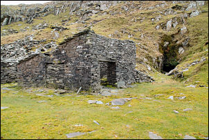
The mine building and heading on Caw. |
There was a sign
saying 'dangerous quarries, keep away etc' which is rather daft
because that an advertisement to visit the site by the average
curious person. All the workings were long since abandoned but
interesting to look at. One large heading was blocked by an iron
grill but it didn't look like much effort would be needed to get in.
I rejoined Park Head Road, which is a rough track and followed it to
Long Mire. Ahead was Caw with its summit in cloud. That was my
objective but I didn't want to continue along the track and lose
altitude. I took a diagonal line up the west side of the mountain
until I came to the old access road to the disused quarry shown on
the map. It was wonderfully made and an easy way up the mountain. At
the quarry some of the buildings were still up to roof level. The
mine heading was fully accessible and open to anyone wanting to
venture inside. |
|
I followed a stream
up the mountain and kept to it as its highest point would be where I
would collect water for my high camp, as I'd have to carry it from
there. When the stream was just a trickle I collected a bag of water
and continued up. I was surprised to see how soon I could see the
summit trig point and reached a nice grassy area to pitch my tent. I
had to wander around for a while to find the best shelter from the
wind. After the tent was up the rain started and for most of the
afternoon I was in cloud again. |

The summit of Caw.
Trig point and wrong sky (on purpose) |