|
|
lat/lon:
54.726510, -03.081749
OS grid ref:
NY 30429 37373
The Drive North on the M6 was
rather dismal due to strong winds and rain. I passed Penrith and
left the motorway to head through Caldbeck and onto Fellside
Farm where there is a small parking area. It was quite windy
when I set off. The rain had just started so I needed full
waterproofs. The first part of my walk was south along the old
access track to Roughton Gill Mines.
|
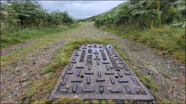
Air valve on water main from the mines. |
|
I'd originally intended taking the path on the east side of Dale
Beck but decided to continue on the track to the mines area. The
main reason was a Ford before the mines that is usually quite
deep. The pass on the east side of Dale Beck is narrow and
through deep ferns which would be difficult in the wet
conditions. That's why I continued along the main track and was
prepared to wade through the ford just before the mines. I was
very surprised and pleased that when I got there someone had put
a large plank across the river on the upstream side. I therefore
had an easy crossing but just as I got over the steady rain
became torrential. |

Ford. |

Plank to save me wading across. |
Up ahead was a building forming part of a water intake system
from the mine drainage. I walked up to it hoping I could get
some shelter but there was none. Nearby was a large iron manhole
lid with a lock on it.
This must be the access to theRoughton
Gill 90-Fathom level mine. Presumably fixed in 1913 when
Carlisle Urban District Council purchased the mine in order to
abstract water draining from the level into the public drinking
supply. This mine appears to have been started after 1852 and
abandoned before 1863. |
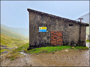
Water intake building. |
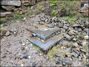
Manhole over 90 fathom level mine. |
|
I headed straight up up Roughton Gill to the east of the
waterfalls continuing up to a footpath that follows the contour
to the east. I continued along this easy route to more mine
workings that I've visited before. The remains of an old mine
shaft were quite handy to get some shelter from the wind so I
stopped to have my sandwiches, but it was still pouring down. |
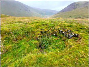
Mineshaft where I had my lunch. |

Boulder on Great Lingy Hill. |
|
I continued along the path until I came to Blea Gill where I
headed up the east side of the Gill along a route I've used
before. Although wet it was an easy climb up towards Great Lingy
Hill. I continued up in the rain until I came to a large boulder
which is actually visible on the Google aerial photo maps. I was
now on bleak open moorland and headed in the general direction
of Lingy Hut. On the way I stopped briefly at the extensive
sheepfolds which I'd seen on the map but never visited. These
are relatively new as they are post and wire. Most of the others
on the fells are very old and of stone. |
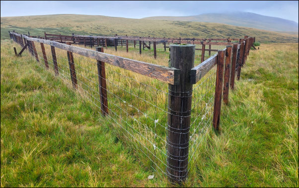
Sheepfold on Great Lingy Hill. |

Lingy Hut. |

Lingy Hut. |
|
I reached the wooden Lingy Hut and decided to have a brief visit
inside and a short shelter from the wind and rain. I went in and
was surprised to see that it was occupied by a young lady still
in her sleeping bag. She was a backpacker and had spent the
night here and was waiting until the rain stopped before
continuing. We chatted for a while and then another backpacker,
this time a man came in through the door. He was sheltering from
the weather also. I didn't stay long and left to continue along
the track to the north. |

Sheltering from the wind and rain. |
Although very wet it was much easier going than the
featureless hill of Great Lingy. I continued up High Pike and
stopped briefly on the summit where there is a memorial stone
bench and post with an information/direction plate. On the stone
bench is the inscription:
‘He is a portion of that loveliness
that once he made more lovely’ by
Percy Shelley 1792-1822. It
doesn’t say who it's in memory of. However, 2 small brass plates
have been added. |

High Pike. |
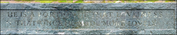
He is a portion of that loveliness that once he made more
lovely.
Percy Shelley (1792-1822) |
In memory of Mick Lewis who loved all these fells. He
died on May 8th 1944 aged 16 years; and |

Sheltering from the wind and rain. |
Also to the memory of his mother Millicent Mary
Lewis of Badger Hill, Nether Row who died 10th November 1970. |

Sheltering from the wind and rain. |
|
The rain had almost stopped and I continued north on a narrower
grass path descending down to an old mine track below. I turned
right to follow the main track down through old mine workings to
the east of the gill. Then I turned left to follow a minor track
across Caldbeck Fells and on to the top of Ingray Gill. It had
stopped raining but I kept my waterproofs on as the sky still
looked threatening. The last part of the route was a pleasant
green track descending back down to Fellside Farm and my car. |

Looking south from Wandale Hill. |
Just below the parking area I was surprised to see a
newish defibrillator fitted to the farm barn wall. As I got back
in the car the rain started again. |
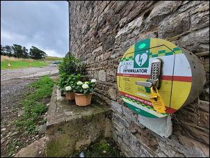
Defibrillator. |
|
|
|
|
|
|
|