|
|
lat/lon: 54.449180, -2.689549
OS grid ref: NY 5538 506195
|
The hottest day of the year had been forecast but my drive north
along the M6 was unremarkable. Yesterday had been warm but today
is supposed to be a few degrees warmer.
I got off at the Shap
junction 39 and drove south along the A6 to the summit layby
where there is a monument to previous travellers along here in
the pre-motorway days. |

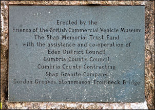
Memorial on Shap summit. |
|
THIS MEMORIAL PAYS TRIBUTE TO THE DRIVERS AND CREWS OF VEHICLES
THAT MADE POSSIBLE THE SOCIAL AND COMMERCIAL LINKS BETWEEN NORTH
AND SOUTH ON THIS OLD AND DIFFICULT ROUTE OVER SHAP FELL BEFORE
THE OPENING OF THE M6 MOTORWAY REMEMBERED TOO ARE THOSE WHO
BUILT AND MAINTAINED THE ROAD AND THE GENERATIONS OF LOCAL
PEOPLE WHO GAVE FREELY OF FOOD AND SHELTER TO STRANDED
TRAVELLERS IN BAD WEATHER. |
 |
Erected by the Friends of the British Commercial Vehicle Museum
The Shap Memorial Trust Fund with the assistance and
co-operation of
Eden District Council Cumbria County Council
Cumbria County Contracting
Shap Granite Company Gordon
Greaves. Słonemason Troutbeck Bridge |
 |
|
I followed the path due west on a steady rise up towards Little
Yarlside. It was soon over 20degC and the ground was very dry.
Over a high point the path continued steeply down to Wasdale
Mouth above Crookdale where it was easy to cross but would be
much wetter in normal weather. There was a steady climb over
Little Yarlside which was a fairly flat summit with no marker
cairn. |
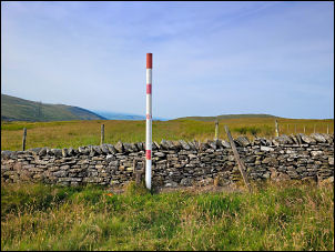
Gas line marker. |
|
As the weather continued to get warmer there were more
horseflies about which landed on the back of my arms and didn’t
make themselves known until they bit me. I followed a quad bike
track away from the wall but soon had to aim for the wall and
steeper ground as the track headed away. I had to cross the wall
to reach the site of an Ordnance Survey trig point. It's not
marked on the map but is a ground level brass bolt and circular
concrete marker ring. I carefully climbed the wall without
disturbing any stones and almost immediately came to the trig
point. Wainwright’s book “The Outlying Fells of Lakeland” has a
drawing of it. It isn’t at the highest point but I suspect the
reason is they needed bedrock for the brass bolt and the nearby
highest point doesn’t have any rocky outcrops. I sat down nearby
to eat my sandwiches in the warm weather. |

Great Yarlside trig point. |
|
|

Great Yarlside trig point. |
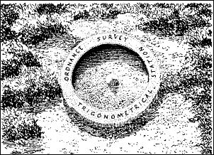
Wainwright's drawing. |

Too many horseflies. |

Erica. |
|
I continued towards Wasdale Pike following the line of a wire
fence through the peat. It was puzzling that the fence isn’t
marked on the Ordnance Survey map. I reached Wasdale Pike and a
distinctive cairn but the pike isn’t at a high point but does
have some limestone outcrops. Down to the north I could see
Sleddale Hall and just over 10years ago on Wed 28th Mar 2012 I
walked up here from Sleddale Hall which was then being
renovated. |
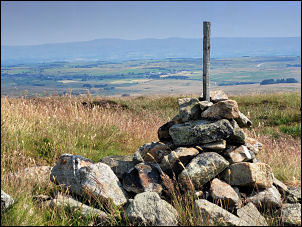
Wasdale Pike |
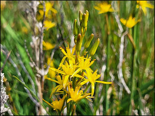
Bog Asphodel. |
My next objective was To Stone or to'ther, a granite boulder.
There is no path to follow so I trudged through the bog area
which was fortunately downhill.
There is some debate about
the naming of this stone.
In Wainwright’s book ‘Outlying
Fells of Lakeland’ he says the following:
Resting on a plinth
of pink granite, rejoicing in the name (according to the
Ordnance Survey) of TO STONE OR TO’THER, which doesn’t make
sense in the local dialect. One wonders whether the surveyor
heard his informant alright – ‘ONE STONE ON T’OTHER’ or ‘TOP
STONE ON T’OTHER’ would be appropriate and understandable.
The 1940s map names the feature as 'Rocking Stone'
Wainwright
also says: “it is off route and not worth a detour because of
its boggy defences.
I reached the distinctive pink granite
boulder and I don't understand how it could have been called a
rocking stone as its fixed solid. |

To Stone or to'ther. |
|
I continued south east to my next objective of Wasdale Head Farm
(ruins). Below was Longfell Gill so I followed it down to a wall
then above the gill where I could see the trees surrounding the
ruins. Some barn walls were standing but the house was
completely demolished. Wainwright had done a drawing with the
roof still on but in a ruinous state. This would be pre 1974
when his book was published. |

Wasdale Head Farm from Wainwright's book. |

All thats left of Wasdale head
Farm. |
|
I had to cross Wasdale Beck swamp to get to the A6 main road and
Wainwrights shows a direct crossing. This would not now be
possible so I followed a track south to a plantation of pine
trees. Where I planned to follow the fence. A sign said “No
Public Access” so I continued through the pines without any
particular problems. The beck was low so no problem crossing. I
reached the road at a gate and hoped to find a milepost shown on
the map. There was no sign of it. I had about a km walk south
along the uphill road. |
|
The temperature was now around 30degC but I didn’t find it a
problem. Shortly before reaching the car I had a quick look at
the lone building on the right. It is Shap Fell Bothy Camping
Barn and has been converted from an old telephone repeater
station. It was locked. I reached the car and was thankful that
I’d put plenty of water in bottles in the boot. |

Shap Fell Bothy Camping Barn. |
|
|
|
|
|
|
|