|
Strathanmore, Dalbreac Lodge, Carn na Coinnich, Strathconon, Scotland. |
|
|
OS
Grid ref: NH 29420 54483 Lat/Long: 57.548187, -04.852106 It was still dark when I set off around 6:30am heading NE along the road. There were some clear patches above where I could see the stars but also a lot of mist obscuring the valley bottom. I reached the turn off to Dalbreac Lodge which is also a collection of estate buildings. Down the private road I crossed the river to the buildings where there were some lights on but no signs of life. A vehicle came down the track but continued by. After the buildings I followed a rough track then hopped across a ford and continued up the track. I gained altitude fairly quickly and could look down on the mist in the valley and some lights shining through. |
|
 Sunrise |
|
 Carn na Coinnich trig post |
|
| It was now coming light and although there was high cloud the distant visibility was very good. I could see the track heading up the pass ahead and looked incredibly steep. When I got there I was as steep as it looked from a distance. I reached the summit of the pass and could see my first main objective, a trig post on the hill ahead. I left the track to descend to a boggy area then up the other side to reach easier ground that I followed to the trig post. |
 A very small Ordnance Survey cairn |
| There was still high cloud and no sun but the distant views were very good. I could see the Kessock Bridge by Inverness in the distance. Down in Strathconan there had been no phone or mobile signal. By the trig post I had a good enough data signal to send a summit photo to Facebook. I headed NW across a flat plateau towards Loch Gruanach. |
 Final descent into Strathconon |
| I passed it to the right and turned left to start a descent to the next glen. The map showed a cairn below and even though it was out of my way I decided to investigate to see if it had any importance. I took a long traverse across rough hillside to get there and when I reached it found it was just three stones placed on top of one another. |
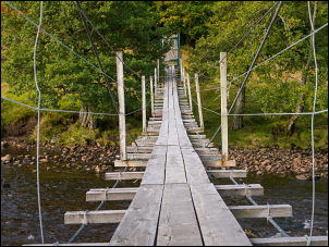 Bouncy suspension bridge |
| It must be one of the simplest artificial features to qualify for an icon and mention on an Ordnance Survey map. To increase its importance I placed another rock on the top. The map showed a descent path down the valley. I followed the route but found little evidence of anything. The occasional deer track helped but as for a path there was none. Above Balnacraig the valley narrowed with pine forest on either side. The path became a rough track and descended through the trees to the valley bottom. I walked to the River Meig and the pedestrian suspension bridge. |
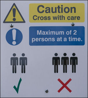 Max of two |
| There was an interesting sign on the far side saying a maximum of two people at once. Back on the road I had a look at the empty church. It is the Strathconon Church of Scotland Parish Church dating from 1830 and designed by Thomas Telford to a standard design. I had a pleasant walk back to the car. |
 The Telford Church in Strathconon |
|
|
|