|
A689
near Alston, Gilderdale Burn, Watcher's Hill, Benty Hill, Cumbria. |
|
|
OS Grid ref:
NY 70192 48417 Lat/Long: 54.829690, -02.465534 I parked in the lay bye on Gilderdale Bridge which is also the boundary between Cumbria and Northumberland. I set off walking back towards Alston along the A689 as far as Harbut Law. Here is where the Pennine Way route emerges from a track below the road, crosses the road and heads up into wet fields. I followed the route through the gate, past the barn and up into the fields. |
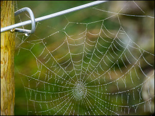 Mist and dew |
| The weather was misty and lots of wet rough ground. The route of the Pennine Way was marked at the road but nothing thereafter. At the first marker by a gate I left it to head SW along a walled track towards Gilderdale. At the next gate I left it to head across the field to climb up to a high track which runs by some interesting old excavations in the hillside. |
 Limestone outcrop |
| They could have been part of the old mining works but it was difficult to say as they were covered in deep undergrowth. Further along were a series of limestone outcrops which looked as though they were a series of quarries to cut stone for the dry stone walls. I reached another area of deep excavations that looked like old mine workings then descended by an old sheepfold to cross very wet ground to the line of the track heading SW into Gilderdale. |
 Gilderdale Burn ford |
| It is mostly wet with some lengths with hard-core base. The track reached Gilderdale Burn where there was a ford. Fortunately the level wasn’t high so I was able to hop over the boulders. Up by the wall I reached Watcher’s Hill and a large impressive ruin. |
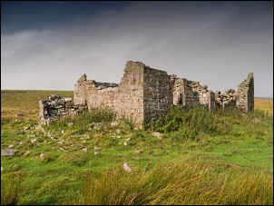 Watcher's Hill ruin |
| The weather had improved so I stopped to eat my lunch. I continued up the valley then started to descend to a large building I’d seen at a distance from my walk last week. It was a two storey building with rood and door still intact. Sheepfolds were nearby and I assumed it was for the shepherds. |
 Possible miner's building |
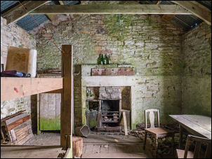 Interior |
 Interior and hearth |
 Solitary |
 Side door |
| I had a look inside then continued along the track where I came to a mine entrance with a date stone of 1870 above the keystone. It was in good condition and a metal grill gate inside didn’t seem to be locked. The building was probably connected with this mine as the map shows another mine further up the valley but I didn’t go up to investigate. |
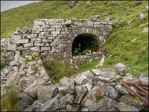 Mine entrance |
| I crossed the river and headed up the rough and wet hillside to reach benty Hill where I was last week. I reversed last week’s route across Scarberry Hill and down Horse Edge. I re-joined the track back to the Pennine Way which I then followed across the fields to Gilderdale Burn which I crossed at the footbridge. Up ahead I could see a couple of walkers but I left the path here to follow the river back to Gilderdale bridge and my car. |
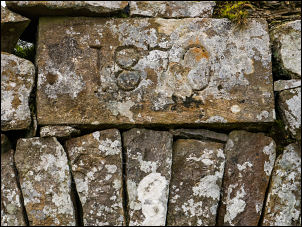 1870 datestone |
 Spectators on Scarberry Hill |
|
|
|
|