|
Above Rookhope, Cuthbert’s Hill,
Hunstanworth Moor, |
|
|
OS Grid ref:
NY 93370 45023 Lat/Long: 54.800037, -02.104655 I drove via Tebay, Brough, Barnard Castle, and Rookhope to Hunstanworth Moor. At the summit is a grassy area which made a good car park by Packlet’s Gate. I set off west along the fence line towards Cuthbert’s Hill but there was no path to follow. It was set at first but improved further out. At a gate in the fence was a footpath sign on the line of Cuthbert’s Way but there was no sign of a path across the moor on either side. |
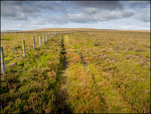 Out towards Cuthbert's Way |
| I continued with the fence and found a quad bike track to follow. I’d planned to leave to fence at a line of grouse butts to the north. I saw them and headed away from the fence. The ground was rough at first but I found a rough track connecting the butts and followed that until I started to descend and reached the gravel surfaced vehicle track. |
 One of the shooting butts |
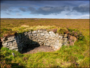
| I was now looking down into Grindstone Cleugh and soon saw the shooting hut ahead. It’s the first time I’ve visited it and was pleased to see one of the two rooms unlocked. It was build of stone, very well maintained and a fire grate with lots of wood piled up inside. The weather was nice so I ate my sandwiches while sat outside. |
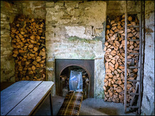 Woodpile inside the hut |
 The stone shooting hut |
|
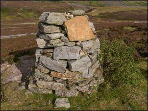
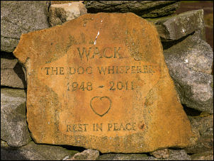
| I continued along the track and noticed a crude stone cairn a short way off. It didn’t look much but I was intrigued by a flat stone set on the top with something written on it. I couldn’t read it so wandered across to have a look. It said: |
 WACK memorial |
|
WACK The Dog Whisperer 1948 – 2011 Rest in Peace. Ashes are nearby |
 WACK stone |
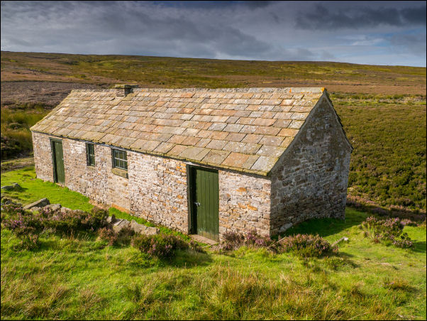
| I returned to the track and continued the descent to the farm at Whitelees. There were a group of men in the barn having a break from sheep sheering. The farmer was with them and I asked him about the cairn. He said it was to commemorate a man who loved the area and the man’s wife had scattered his ashes at the cairn. I continued down the farm track to the tarmac road, up the hill to Wagtail house then up the grassy hill to Cocklake Plantation. |
 Wagtail |
| I reached the road near Haining Plantation intending to follow a path shown on the map. The path sign pointed to a wall with no gate or stile. I found another gate and crossed the fields to a lower road and on to the area that was the old Bolthope mine area. There were some concrete bases among the gravel as I walked up the old mine access road. The whole area had been landscaped and nothing remained of the old workings. Higher up was a solitary building and above that Whiteheaps Dam reservoir. |
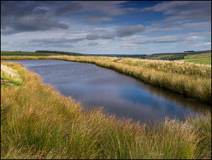 Whiteheaps Dam reservoir. |
| I followed a track up the field to a gate where there was no obvious path even though the map shows one. I followed a line of shooting buts up to the road then headed back towards the car. On theleft was a tall stone set in the ground but even with close inspection couldn’t see any inscriptions. It is shown on the modern map as ‘stone’ and even the 1850 map just call in ‘stone’. It is close to the line of Cuthbert’s Way footpath but there is now evidence of a path even though the map shows one. I continued up the road back to my car. |
 Cairn above Allenheads on the drive home |
|
|
|