|
Dowthwaite Head, Birkett Fell,
Watson's Dodd, Clough Head, Old Coach Road, Cumbria. |
|
|
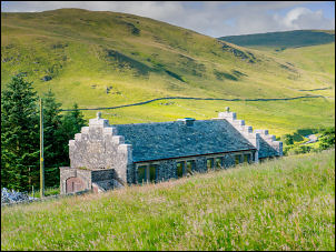
OS Grid ref:
NY 37999 21902 Lat/Long: 54.588490, -02.960941 I drove up the M6 motorway in sunshine but by the time I reached the small car park at High Row near Dockray the clouds had rolled in. I set off SW along the lane towards Dowthwaitehead farm. On the way I passed the old Penrith Water Board building with the inscription: PENRITH RDC WATERWORKS 1932. At the farm they were shearing sheep and the farmer looked on while young man the shearing. I looked hard work but he was quick and did an excellent job. |
 PENRITH RDC WATERWORKS 1932 |
 Destined for spinning |
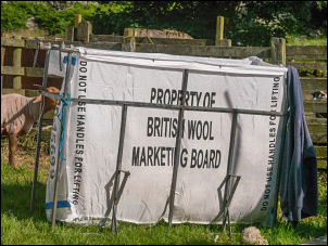 British Wool Marketing Board |
| It was good to hear that the wool was going to be used for various purposes depending on the colour. One pile was going for spinning and the rest was being put in a large bag labeled ‘Property of British Wool Marketing Board’. The sun had now come out and things warmed up a bit. |
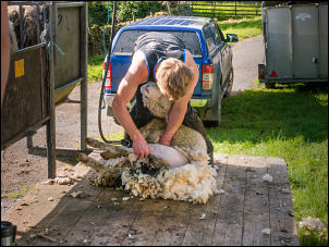 Sheep shearing |
| I continued through the farm and across Airta Beck at the footbridge. The path continued up the hillside but soon became indistinct and very wet in places. I left it below Birkett Fell and headed straight up the fellside hoping things would get dryer but they didn’t for quite a while. I reached the main wall and followed it up to near the summit. |
 Footbridge over Aira Beck |
| It was a great viewpoint and I was lucky that the weather was fairly clear. I left the wall to cross to the Birkett Fell cairn which has its own stone nameplate. I’d seen a lady walker on the way up and she had stopped by the cairn. I said hello and continued to the next high poing then followed a faint path to three cairns on Hart Side. |
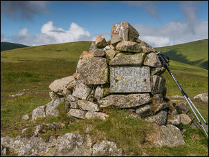 Birkett Fell plaque |
 View from Birkett Fell |
|
| There is also what looks like a man made trench cut in the rock which looked like mine investigation works. I crossed open boggy ground to Stybarrow Dodd where there were more people out enjoying the good weather. I continued to Watson’s Dodd and good views down towards Keswick. Then the climb up to Great Dodd took me to the 857m and the highest point on the walk. From here I could see all the highest mountains in Cumbria, Helvellyn, Scafell Pike and Skiddaw. |
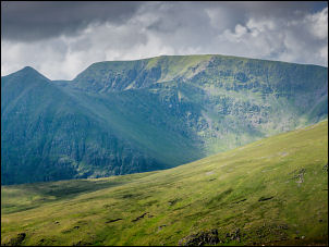 Looking towards Helvellyn |
| The descent to Calfhow pike was steep at first and rather loose but soon improved. After Calfhow a long wet track took me to Clough Head and the trig post. There was a large group of people who seemed to be a walking group. They were sat around in the wind eating their lunch. As I descended to the east I could see along Wanthwaite Crags and two hang gliders making good use of the windy conditions and updraft. |
 Skiddaw in the distance |
 Clough Head trig post looking to Skiddaw |
|
| On the ground below the crags I could see several others getting their gear ready. I left he path and descended steeply down to the Old Coach Road. I passed and old railway goods carriage on the way that had been used as a shelter. It was high up the fell and must have been difficult to get it there. Several people were walking along the Old Coach Road and a t Mariel bridge a group of young people were resting on the grass. I continued east and for the first time saw a vehicle approaching. It was a land rover and I’m not sure if it’s a private track or not. Back at my car the car park was full. |
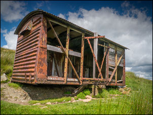 Old railway carriage |
|
|
|