|
Dunmail Raise, Steel Fell, Wyth
Burn, A591 road repair, Cumbria. |
|
|
OS Grid ref:
NY 32952 11157 Lat/Long: 54.491294, -03.036589 I drove to the lay bye on the summit of Dunmail Raise to start my walk. The last time I started a walk here the road was closed due to the floods of Dec 2015 washing the road away along a section between Dunmail Raise and Thirlmere. |
 Dunmail Raise cairn |
| I’d seen a path up Steel Fell shown on the Open Street Map website that isn’t shown on the Ordnance Survey map and decided to check it out. I left the road by climbing a stile over the fence and straight up the fell side. I could see a path ahead and even though it looked indistinct higher up it turned out to be OK the whole way up. It also gave a nice view back down to the Dunmail Raise summit and large mound of stones that is actually the Dunmail Raise large cairn that gives its name to the pass. |
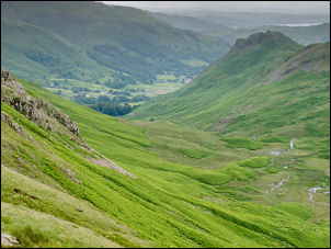
 Looking down on Dunmail Raise |
| The weather wasn’t great but the rain held off under mostly cloudy skies. At the top of the climb I was soon on flat grass and only a short walk to the summit cairn. There were nice views but it was too cold and windy to hang around. For the last day of June the temperature of 10degC felt colder. |
 Steel Fell summit cairn |
| I headed west along the meandering faint path that got wetter the further I went. Shortly before I reached the main Greenup Edge path that is also the ‘Coast to Coast’ route I turned off to the right to follow a faint path down towards Wyth Burn. There is no path shown on the map until part way down the valley. |
 Looking across to Helm Crag |
| The path was variable and some sections had been washed away during the Dec 2015 floods. It is an impressive valley to walk through but the path indicates it is not visited often. Two thirds down the valley the path crosses With Burn at a substantial wooden footbridge. The map shows paths continuing down the valley on both sides of the river but I crossed over to follow the NW side. |
 Waterfall on With Burn |
| I reached the minor Thirlmere road at Stockhow Bridge and turned right to reach the main A591. There is no path along the A591 so I crossed over to follow the single track road that was tarmacked earlier in the year to take buses around the repair works. It is also the original route of the A591 and the length that collapsed was built around the 1930s. On the track the stone bridge had been strengthened by putting a steel bridge over the top. At the next steel bridge I crossed Birkside Gill and turned north to reach the repaired section of road. I tried to re-take photos where I’d taken them in Jan 2016. I had to walk back up towards Dunmail Raise along the busy A591 and had to be very careful of fast vehicles approaching. Thankfully I was soon able to climb the wall and join the original path that had now been surfaced with tarmac to act as a cycle track. I followed it back to the summit then back to my car. | |
 A591 Jan 2016 |
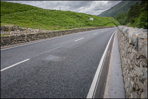 A591 today |
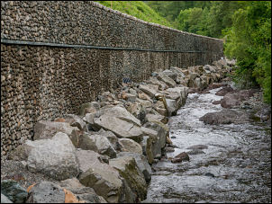 The repairs by the river |
 The new cycletrack |
 |
|
|
|
|