|
Dacre, Dalemain, Pooley Bridge,
Dunmallard Hill, Cumbria.. |
|
|
OS Grid ref:
NY 46081 26254 Lat/Long: 54.628528, -02.836697 The start of my drive was in the dark and rain. I left the M6 at Penrith and then on to the outskirts of Dacre where it was still raining. There was a useful lay-bye and picnic area by the bridge over Dacre Beck. |
 Entering Dacre |
 Dacre seat |
 Dacre seat with E R 1953 |
| It was a short walk into Dacre village centre then right along an unsufaced track to the impressive Dacre Castle. |
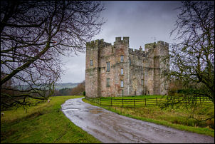 Dacre Castle |
|
Dacre Castle is a moated tower house dating back to the mid-14th century
and is a grade I listed building. The wet and sometimes muddy track continued for over a mile to the western approach of Dalemain House. |
 Dalemain rear |
| It is a public footpath but a sign says bikes not allowed. I walked into the main courtyard, which is still a public footpath, but nobody was around and nothing was open. I left through a stone arch and headed towards the main A592 road. |
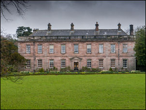 Dalemain front |
| I turned right and then over a stile into the fields to have a look at Dacre Bridge dating from somewhere in the 18th century and a grade II listed structure - English Heritage Building ID: 73766. It is private and sign certainly makes that clear. |
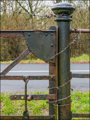 Gate by Public Footpath |
| The gate buy the stile is on a public footpath but is secures shut with barbed wire. I find this sort of thing quite disturbing. |
 Dacre bridge - Keep Off! |
| The path continued through the fields and by woodland to emerge back on to the A 592. I crossed over and back into the fields to reach the banks of the River Eamont which I followed to Pooley Bridge. The river is the only outlet for Ullswater and during the Dec 2015 floods was so high that it washed the original 18th century bridge away. |
 New Pooley Bridge |
| The new bridge is a steel lattice construction and a temporary structure which will stay until a permanent bridge design and construction can be agreed. |
 New Pooley Bridge |
 Pooley Bridge temporary replacement |
|
 Dunmallard Hillfort mound |
|
| The sign says this could take 2 years. I followed a path steeply up Dunmallard Hill which is densely wooded and has the well-defined ditch of the remains of a small Iron Age fort. Because of the trees there was little to see from the summit. I followed the path down the west side of the hill and re-joined the A592 again. After a short walk along the shore of Ullswater I left the road at the Boathouse and headed up towards Salmond’s Plantation. |
 Maiden Castle ditch |
|
After climbing the public footpath through an open field I headed into
woods then up onto the summit area. The woods thinned here and I took an
easy descent down to the west and into a field where I soon joined another
public footpath and up a wet field to the defensive ditch of Maiden
Castle. A sign there gives the following description: Maiden Castle is a defended settlement (probably home to a family group) of the 1st millennium BC. It would have been located within or near to arable fields. The enclosure is circular, has a diameter of about 65 metres and is defined by an inner rampart, ditch and counterscarp bank. The ditch and the banks, which may have been topped by wooden fences, would have been much more substantial to provide protection against attackers. A few very low earthwork features are visible in the interior of the enclosure including two circular platforms of about eight metres diameter which may indicate the positions of the circular huts. These are likely to have been of timber construction, with wattle and daub walls and thatched roofs. You are invited to enter the site and view the archaeological remains. Please note that there is no through-route beyond the monument and you must exit again at this point to re-join the path. Maiden Castle has been designated as a Scheduled Ancient Monument by the Secretary of State for National Heritage: it is considered to be of national importance and it is an offence to damage the site or to use a metal detector in the scheduled area. I descended a wet field to an isolated barn where the whole area was a horribly deep muck midden. The stile on the path was collapsed as the one by Maiden Castle was. The continuing track to the farm was so deep in mud I had to stay in the field. The farm access track soon reached the minor road which I walked along to the north. A couple of Lake District park workers had just finished fitting a new gate to another path leaving the road. |
|
 Today's new gate replacing the old kissing gate |
 The old kissing gate from 2009 Google |
| It turns out the original one wasn’t too old, just one of the idiotically small kissing gates that you can’t get through with a rucksack on. The weather continued overcast and dull as I continued back to Dacre, at least the rain had stopped. |
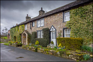 Returning to Dacre |
|
|
|