|
Little Salkeld, Lacy's Caves,
Eden Bridge, Kirkoswald Castle, Long Meg, Cumbria. |
|
|
OS Grid ref: Lat/Long: 54.718705, -2.674894 There was another bad weather forecast of wind and rain so I have planned a low level walk for today. I drove north on the M6 to Penrith. The A66 to the east was closed due to lorries being blown over overnight. I reached the small village of Little Salkeld and parked my car in a muddy layby by a minor road. It was very overcast and dull with light rain as I set off down the narrow lane to the west. I was soon on a private track. Part way along I could see a brick/ceramic map artwork in the grass verge to the left done by Michael Eden and children from local schools. It represented the River Eden with villages along it. |
 |
 Ceramic artwork |
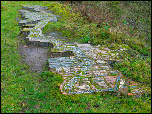 Ceramic artwork map |
|
I continued to the
area of
Long
Meg mine workings which are long since abandoned. It was a gypsum mine operated between 1880 and 1976. The mine was opened by the Long Meg Plaster Company Ltd. in 1880 and eventually closed by the British Plaster Board Ltd. (now known as British Gypsum) in 1976. A narrow fenced off area took me down to the railway and then along the east bank of the River Eden. The path I was following had remnants of an old railway track along it. This was used in connection with the mine workings and some old structures of the mine were evident to my right. |
 Long Meg mine |
| As I looked across the river to the railway viaduct I could see the tide mark left by the December 2015 floods. It was quite scary seeing how high the river had come back then. The path was very muddy in places and it was sometimes difficult getting past the still high river level. |
 River Eden in flood |
|
I reached my first objective of
Lacy’s Caves which I haven't visited for many years. Just as I
approached extremely heavy rain started and luckily I got into the caves
just as the rain and wind increased. I had brought my tripod and
additional lighting with me so I could take interior photographs. |
 Lacy's Caves |
 Lacy's Caves |
|
 |
 |
| They are carved into a sandstone cliff and were commissioned by Lieutenant Colonel Samuel Lacy of Salkeld Hall in the 18th century. The caves were used by Colonel Lacy as a romantic folly for entertaining his guests and the area was originally planted with ornamental gardens. |
 Lacy's Cave entrance above the River Eden |
 Lacy's Caves graffiti |
|
 The path is too low |
|
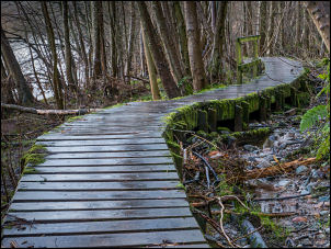
| Fortunately the rain eased off so I continued my walk north along a continuing wet and muddy path. Several sections have been spanned by wooden duckboards but these were fitted far too low and were submerged. This meant a wide detour in several places. Eventually I emerged from the woods at Kirk Bank where a section of river bank had fallen into the river taking the footpath stile with it. |
 Wet and slippery |
| However it was quite easy to clamber around the fence and continue to the road at Daleraven Bridge. I saw a sign there which said that the path I had just come along had been closed. I left the road to follow a wet path along the riverbank where I could see more evidence of flood damage and lots of remaining debris scattered across the fields and in the hedges. I reached the Eden Bridge near Lazonby where I re-joined the road which is now the B6413 and followed it to Kirkoswald. |
 Eden Bridge |
| I didn’t go onto the village but turned up the narrow lane to the east and into a wet field to inspect the remains of Kirkoswald Castle. The Castle dates from around 1200 but was destroyed by Robert the Bruce in 1314. It was rebuilt and extended in the late 15th Century. Only one 10m tower remains above ground with vaulted dungeons nearby. The moat can still be seen. |
 Kirkoswald Castle |
| I continued southeast across very wet fields and an indistinct route where it was difficult to follow at times. Thankfully I emerged from the fields after a mile or so into the farmyard of Old Parks farm and continued along the farm track to reach Glassonbybeck and follow the road into Glassonby and on to a track to the west. |
 Church of St Michael |
|
Here I came to the Church of St Michael. It was a very picturesque church and the path went through the graveyard. Fortunately I was able to get into the church as it wasn't locked. |
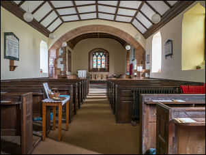 Church of St Michael |
|
After a brief look round I collected my rucksack from outside and
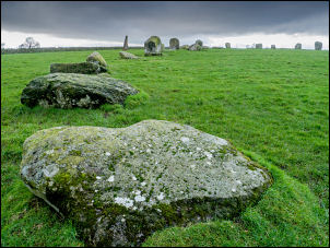
continued across the fields and Bronze Age stone circle of
Long Meg and Her Daughters. |
 Long Meg |
|
Long Meg is a large standing stone with ring markings and the daughters
are in a large stone circle of 27 remaining upright stones. The weather
was very bad for photographs as it was heavily overcast and dull. There is
a small car park which can take about 3 cars. I followed the road south
and then along a track and back onto the road and on to Little Salkeld. |
 Long Meg Daughters |
 Long Meg Daughters |
 Ring markings on Long Meg |
|
|
|