|
Glen Mark, Queen's Well, Mount
Keen, Balmoon's Cave, Invermark, Scotland |
|||||||
|
OS Grid Ref: NO 44669
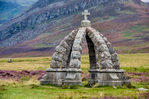
80375 It was still dark when I woke at 5 a.m. and after a quick coffee and some breakfast I set off along the road and up to the right to pass the House of Mark. The track continued in a northwest Direction up Glen Mark. It was now coming light but unfortunately still overcast with cloud. After 2 miles I could see the Queen’s Well Monument ahead which is a stone structure erected in 1866 to commemorate the visit of Queen Victoria as she passed on one of her tours. |
|
||||||
|
|
||||||
|
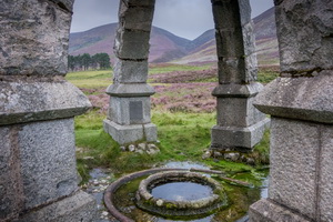
It is an interesting well
as the water issues from an artesian spring in the middle of a flat
grassy area. It is topped with a crown shaped structure of stone. |
|
||||||
|
|
||||||
|
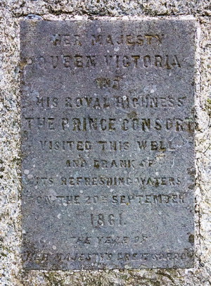
Marked on the stone is: |
|
||||||
|
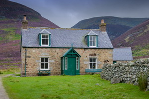
I left the spring to continue up the Glen to the isolated building of Glenmark which was empty but is available for rent as a holiday cottage. The track was now a vehicle track for the shooting parties. |
|
||||||
|
I followed it up past Couternach and above ladder Burn. Up a zigzag section onto the high Moor I reached the shooting butts. I left the vehicle track to follow a very well stoned pass which soon entered cloud. I continued to the summit of Mount Keen but couldn't see anything other than the track ahead. Before the summit was a boundary stone with a letter ‘B’ incised into it. |
|
||||||
|
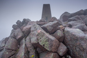
The summit of Mount keen at 939 meters was a boulder tangle of rocks with a trig post on the summit. It was now quite cold at 5 degrees C and I cold south east wind blowing. I didn't stay long but managed to get a signal to check my phone. |
|
||||||
|
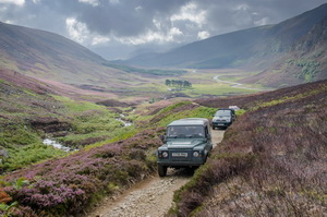
The return was just a case of following my access route but on the way down I wanted to check the location of a cave shown on the map. As I descended I saw some vehicles coming up the track. They drove slowly bye on the rough track and I even got a wave from the drivers and some of the occupants. |
|
||||||
|
Before reaching the isolated building of Glenmark I cut off the track and headed across open heather to descend to the Water of Mark to a Ford shown on the map. There weren't sufficient boulders to get across so I took my boots off and waded. |
|
||||||
|
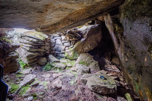
I then walked another mile west and up the Glen to the site of Balnamoon’s Cave which is mentioned on a guide board farther down the Glen. I spent about an hour trying to find the cave based on the information on the board. It turned out to the incorrect and I found the cave to the south east of the water fall and not south as indicated. The cave was used after the Jacobite defeat at Culloden. |
|||||||
|
After checking the interior I returned down the Glen and kept by the river managing to cross higher up than the ford where boulders were available to hop over. I returned to Queen’s Well and then reverse my route along Glen Mark and back to the car at the car park. |
|
||||||
|
The link below gives a
very good history of the cave: |
|||||||