|
Blanchland, Ruffside Moor,
Belmount Farm, Presser Pumping Station, Co Durham.
[17.7 km]
Thu 06 Aug 2015 |
|
|
|
OS Grid Ref: NY 96485
50433
Lat/Long: 54.848693, -02.056271
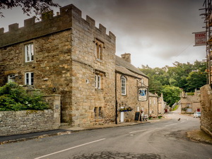
Drove via Hexham to Blanchland for the
start of my walk. The arch building was still covered in scaffolding as
I walked through the village and out along the B6306 towards Edmundbyers. |
|
|
There was no footpath so
I followed a path through woodland for a while to avoid the road. Back
on the road I walked to the entrance gate to the derelict farm of West
Ruffside. An estate sign on the gate said ‘No Access’ so I continued
along the road to a gate with no sign then headed up the wooded West
Plantation on Ruffside Moor. |
|
|
|
Looking
back to Blanchland |
|
|
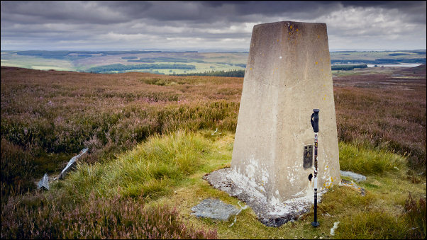
Trig post on Ruffside Moor |
|
There was a line of
shooting butts and an access track which took me almost to the summit of
Bainbridge Hill. The last part of the walk was through the heather to
the summit trig post. It was overcast but mostly fine weather and there
were great views all around. I started my descent by following the fence
line to the SW. There was no path so I had to negotiate the heather
which was quite deep in places. At a junction of fences and a gate I
reached the path and continued over the hill to the long abandoned farm
of Belmount. |
|
|
|
|
Belmount
byre, scene of the murder |
|
|
|
It was here in Jan 1880
that
Robert Snowball was murdered by having the back of his head hit with
a sledge hammer. The main suspect was the housekeeper Mrs Jane Barron,
the widow of a lead miner. She was never sentenced and moved away from
the area to continue as a housekeeper.
|
|
|
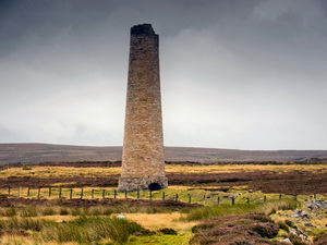
I continued along the
track to the road at Near Sandyford. I wasn’t on it long and continued
on another track towards Sykehead. I left the track to visit the
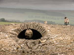
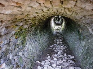
isolated chimney by Sykehead Dam, The chimney was the end of a long
underground flue that comes up the moor. I followed the collapsed flue
and found some sections still almost intact. As I descended I could see
the building and chimney of the Presser Pumping Station. |
|
|
|
|
|
I reached the track and
walked to the deserted pumping station buildings. They were deserted and
empty inside. The area was used for lead mining but apparently the
pumping station was built after the mines closed and was used to supply
water to Consett. I returned to the road and followed it round to the
Derwent Lead Mines area. I noticed a ridge in the field which looked
like an old flue but checking the old map turned out to be the Deborah
Incline between Deborah Mine level and Presser Lead Mine. |
|
|
Down through the woods I
tried to find a river crossing. I crossed at what looked like a
collapsed bridge but there was no way to continue on the other side. I
noticed a footbridge further up the river so crossed over that. An
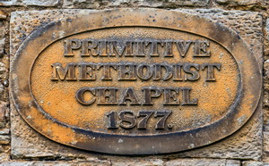
overgrown path took me up to a terrace of cottages and a Primitive
Methodist Chapel dated 1877. |
|
|
|
Primitive Methodist Chapel |
|
|
|
|
Primitive Methodist Chapel |
|
|
|
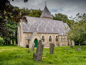
The path continued to the
road where I continued to Hunstanworth with its distinctive St James’s
Church with patterned roof. I descended to the River Derwent where I
followed the riverside path back to Blanchland. The car park is by
donation and £1 is suggested. I put a bit more in. |
|
|
|