|
Loweswater, Burnbank Fell, Gavel
Fell, Hen Comb, Kirkstile Inn, Cumbria. |
||||
|
OS Grid Ref: NY 13449
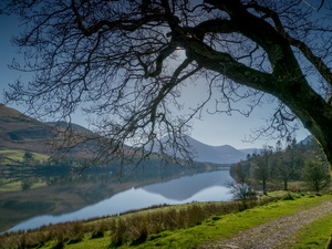
21040 The recent calm, clear & sunny weather continued into today. There was a lovely sunrise as I drove north along the M6. I reached the small car park to the SE end of Loweswater at Maggie’s Bridge to find only one other car in the car park. I set off along the farm track to Watergate Farm then the track heading into the trees. |
|
|||
 Loweswater |
||||
 Logs by Loweswater |
||||
|
I tried a couple of photos on my new HTC M9 phone camera which looked OK on the screen. Up an old track I reached Hudson Place where I found the path marker on a slate at ground level. The path skirts round the farm and the next path marker was in a field set in a flat slate on the ground. After Jenkinson Place and Iredale Place I was heading up on a farm track then out onto the fell. Below Burnbank Fell I left the path to follow a wall then a steep scramble up to a faint path that isn’t shown on my map. |
|
|||
|
It took me to the fence at the summit of Burnbank Fell. The clear sun was now starting to haze over the distant views, though I could still see Scotland across the Solway Firth. I managed to find a signal for my phone and was able to upload a couple of my earlier photos to Facebook. |
|
|||
|
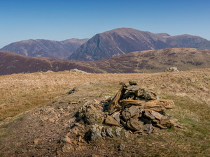
Continuing south to Blake Fell some stretches of path were a bit soggy, even with the recent lack of rain. Continuing down to Fothergill Head I climbed again to Gavel Fell. The views were good, especially those towards Buttermere and Mellbreak. I now needed to descent to Whiteoak Moss but there was no path shown on the map and none on the ground. |
|
|||
|
It didn’t matter because the steep descent was straightforward. Across the tussocky moss I started the climb of Hen Comb. I found the faint path that climbs it from the south and headed steadily up. At a distance the mountain looked a long way up but taking it steady on the path I seemed to get to the top fairly quickly. It is a very nice summit and I could see several people on their way up from the north. |
|
|||
|
I started the steep descent then ambled along the flat and easy stretch across Loweswater Fell. After a mile I followed the path down to Mosedale Beck and easily hopped across the ford. In wet weather I can see this crossing being a problem. Then I joined the track which descended between walls towards Loweswater. Over the wall to the left I could see the ancient earth works in the field though nothing seems to be known about them. |
|
|||
|
Down the track I came to the picturesque Church Bridge and would have to have gone in the field to take a picture but a sign said private no entry and there too many people about. At the Kirstile Inn there were several people enjoying food an drinks out in the sunshine. I was now on the road and walked the remaining mile back to the car park and my car. |
|
|||
|
|
||||